
Eagle Creek (Multnomah County, Oregon) facts for kids
Quick facts for kids Eagle Creek |
|
|---|---|

Metlako Falls on Eagle Creek
|
|

Location of the mouth of Eagle Creek in Oregon
|
|
| Country | United States |
| State | Oregon |
| County | Hood River County |
| Physical characteristics | |
| Main source | Thrush Pond near Eagle Butte 3,455 feet (1,053 m) 45°32′58″N 121°54′15″W / 45.54944°N 121.90417°W |
| 2nd source | Wahtum Lake 3,727 feet (1,136 m) 45°34′52″N 121°47′56″W / 45.58111°N 121.79889°W |
| River mouth | Columbia River east of Bonneville Dam Oregon 79 feet (24 m) 45°35′26″N 121°55′57″W / 45.59056°N 121.93250°W |
| Basin features | |
| Progression | Eagle Creek → Columbia River → Pacific Ocean |
Eagle Creek is a beautiful creek located in Hood River County, Oregon. It flows through the amazing Columbia River Gorge. This creek is a smaller stream that eventually joins the mighty Columbia River.
Eagle Creek flows for about 15 miles (24 km). It starts from Thrush Pond, which is found between Eagle Butte and Tanner Butte. The creek then travels until it reaches the Columbia River, close to the Bonneville Dam.
A big branch of Eagle Creek is called the East Fork Eagle Creek. This branch begins at Wahtum Lake. It connects with the main creek about two-thirds of the way from Thrush Pond to the Columbia River. Indian Mountain separates these two parts of the creek.
Contents
What is a Drainage Basin?
The Eagle Creek drainage basin is the largest area of its kind in the western or central Columbia River Gorge. A drainage basin is like a giant bowl. All the rain and snow that falls within this "bowl" eventually flows into Eagle Creek.
The edges of this basin are formed by different natural features. To the west, you'll find Tanner Ridge. To the east, there's the Benson Plateau and Chinidere Mountain. To the south, the basin is bordered by Indian Mountain and Waucoma Ridge. Another important stream that feeds into Eagle Creek is Opal Creek. It flows from Tanner Butte and joins Eagle Creek just above Tenas Falls.
Amazing Waterfalls
Eagle Creek is famous for its many beautiful waterfalls. As you travel upstream from where the creek meets the Columbia River, you'll see some incredible sights.
Some of the most well-known waterfalls are Metlako Falls, Punch Bowl Falls, Skoonichuk Falls, and Grand Union Falls. Further up, you'll find Twister Falls and Sevenmile Falls.
Many smaller streams flow into Eagle Creek, and they have their own waterfalls too! These include Sorenson Falls, Loowit Falls, Four Mile Falls, Tenas Falls, Wy'east Falls, and Tunnel Falls.
Fun Things to Do

Eagle Creek is a super popular spot for outdoor activities. The Eagle Creek Trail #440 is a famous path that runs for about 13.1 miles (21.1 km) along the creek. It starts from the Historic Columbia River Highway State Trail. The trail then goes all the way to a spot where it connects with the Pacific Crest Trail near Wahtum Lake.
The lower parts of this trail are some of the most visited trails in the Columbia River Gorge. There are also many other trails on the mountains and ridges nearby. These trails connect to the larger network of paths throughout the Gorge.
History of Eagle Creek

The Eagle Creek area faced a big challenge in 2017. A large wildfire, known as the Eagle Creek Fire, started near Punch Bowl Falls. The fire began after a firecracker was used in the canyon during a very dry period.
Because of the fire, there was a higher risk of landslides and other dangers. For safety, the area was closed to visitors until January 2021. The trail briefly opened again, but it had to close just two weeks later. This was because heavy rains caused new landslides, making the area unsafe once more.
Images for kids
-
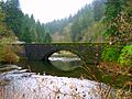
Eagle Creek Bridge, in 2010

