East Gosford facts for kids
Quick facts for kids East GosfordCentral Coast, New South Wales |
|||||||||||||||
|---|---|---|---|---|---|---|---|---|---|---|---|---|---|---|---|

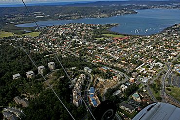
An aerial view of East Gosford
|
|||||||||||||||
| Established | 1991 | ||||||||||||||
| Postcode(s) | 2250 | ||||||||||||||
| Elevation | 14 m (46 ft) | ||||||||||||||
| Area | 2.1 km2 (0.8 sq mi) | ||||||||||||||
| Location |
|
||||||||||||||
| LGA(s) | Central Coast Council | ||||||||||||||
| Parish | Gosford | ||||||||||||||
| State electorate(s) |
|
||||||||||||||
| Federal Division(s) | Robertson | ||||||||||||||
|
|||||||||||||||
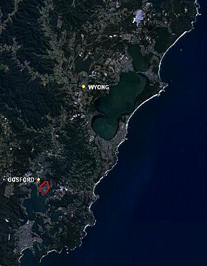
East Gosford is a suburb located on the Central Coast of New South Wales, Australia. It sits just south-east of the main Gosford town centre. East Gosford is part of the Central Coast Council area.
The land was first home to the Guringai (Wanangine) People. The suburb gets its name from Archibald Acheson, 2nd Earl of Gosford. He was a British governor who worked with New South Wales Governor George Gipps in Canada.
In 2016, about 4,238 people lived in East Gosford.
Contents
History of East Gosford

Early Days and Samuel Peek
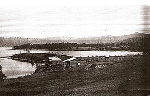
The area where East Gosford is today was sold to Samuel Peek. He was a tea merchant from Sydney. In 1841, the land was mapped out. A year later, Peek started selling parts of it.
Soon, a wharf (a place for boats to dock) and several shops were built. Peek also built a three-story hotel. In 1850, he and his family sailed to England. Sadly, when they returned in 1857, their ship crashed. Everyone in his family died. Many of his papers were lost. Without anyone to look after his buildings, they slowly fell apart.
The Moving Church
In 1858, a small church made of sandstone was built. It was in a central spot for people from nearby towns. But when the railway opened, more people moved closer to Gosford.
The church became empty. So, people decided to move it, stone by stone. It was rebuilt in Mann Street, Gosford. You can still find it there today.
The Punt Bridge Story
Erina Creek is on the eastern side of East Gosford. Long ago, boats like ketches and steamers used the creek. They carried timber in and out. A person used a punt (a flat-bottomed boat) to carry people and goods across the creek.
In 1884, the government decided to build a bridge. It was an iron drawbridge with wooden parts. It cost a lot of money to build. Part of the bridge could roll back to let boats pass. Men had to crank a machine by hand to open it. The bridge opened seven times a day.
The last steamer went through in 1928. The old Punt Bridge was replaced in 1962. It is still called The Punt Bridge. Today, it is part of the Central Coast Highway.
Schools and Learning
In 1913, two sisters, Marion and Aileen Macabe, opened a girls' school. It was first at Boomera. Later, the school grew and moved to a house called Mona Vale. This house was built in 1889. Today, Mona Vale is part of St Edward's College.
The school took both students who lived there (boarders) and day students. They taught many subjects. Students could also learn Esperanto (a made-up language), public speaking, dancing, and music. Popular sports were swimming, rowing, and tennis. Students even learned horse-riding. In 1923, the sisters moved their school to Lindfield.
Later, in 1951, the Christian Brothers bought Mona Vale. They started building St Edward's College in 1952. Mona Vale was fixed up. For many years, it was used as a staff room and office for the college.
East Gosford has four schools today. St Patrick's and Gosford East Public School are for younger students (kindergarten to year six). St. Edward's Christian Brothers College is a Catholic boys' school. St. Joseph's Catholic College is a girls' school. Both are for students from years seven to twelve.
Community Hubs and Gardens
East Gosford is home to the Gosford Regional Gallery. It also has the Gosford/Edogawa Commemorative Garden. This Japanese garden was a gift from Edogawa, a part of Tokyo, Japan. The garden opened in 1994.
Local Banking and Safety Improvements
In the past, East Gosford had branches of all four major banks. But by 2000, these banks had closed. So, the local business group worked to open a Bendigo Bank Community branch. This bank opened on August 5, 2000. It has helped local shops and businesses do better. The East Gosford Community Bank has grown. It now has another branch and an agency in other towns.
In 2004, a pedestrian bridge was built over York Street. This bridge makes it safer for students from the four schools to cross the road. The bridge cost $2.5 million to build. It has two lifts for people with disabilities.
On August 9, 2006, the main road through East Gosford was named the Central Coast Highway. This helps drivers who don't know the area find their way.
Who Lives in East Gosford?
The 2016 census counted 4,238 people living in East Gosford.
- About 2.7% of the people were Aboriginal and Torres Strait Islander.
- Most people (72.3%) were born in Australia.
- The next largest group (4.8%) was born in England.
- Most homes (82.5%) spoke only English.
- For religion, the most common answers were No Religion (27.2%), Catholic (25.5%), and Anglican (18.3%).


