East Hazel Crest, Illinois facts for kids
Quick facts for kids
East Hazel Crest, Illinois
|
||
|---|---|---|
|
||
| Motto(s):
The best little village in Illinois
|
||

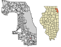
Location of East Hazel Crest in Cook County, Illinois.
|
||
| Country | ||
| State | Illinois | |
| County | Cook | |
| Township | Thornton | |
| Incorporated | 1928 | |
| Government | ||
| • Type | Mayor-council | |
| Area | ||
| • Total | 0.78 sq mi (2.03 km2) | |
| • Land | 0.78 sq mi (2.03 km2) | |
| • Water | 0.00 sq mi (0.00 km2) | |
| Elevation | 620 ft (190 m) | |
| Population
(2020)
|
||
| • Total | 1,297 | |
| • Density | 1,654.34/sq mi (638.51/km2) | |
| Time zone | UTC-6 (CST) | |
| • Summer (DST) | UTC-5 (CDT) | |
| ZIP Code(s) |
60429
|
|
| Area code(s) | 708 | |
| FIPS code | 17-21904 | |
| FIPS code | 17-21904 | |
| GNIS ID | 2398777 | |
| Wikimedia Commons | East Hazel Crest, Illinois | |
East Hazel Crest is a small village located in Cook County, Illinois, in the United States. It's a community found just south of the big city of Chicago. In 2020, about 1,297 people lived in the village. Its motto is "The best little village in Illinois."
Contents
History of East Hazel Crest
East Hazel Crest was once part of a nearby village called Hazel Crest. This was back in 1911. However, the Illinois Central Railroad built its train tracks higher up. This separated the community that would become East Hazel Crest from the rest of Hazel Crest.
Because of this separation, the people living there decided to form their own village. They voted to become their own village in 1918. Later, East Hazel Crest added a small shopping area and a neighborhood called Bremerton Woods. This area is now home to the village's main office and the local train station.
Geography of East Hazel Crest
East Hazel Crest is located at coordinates 41°34′35″N 87°39′8″W / 41.57639°N 87.65222°W. This tells us its exact spot on a map.
The village covers a total area of about 0.78 square miles (2.03 square kilometers). All of this area is land.
Neighboring Communities
East Hazel Crest is surrounded by several other towns. These include:
Population and People
The population of East Hazel Crest has changed over the years. In 1920, there were 394 people living there. The population grew to 1,885 people in 1970. By the 2020 census, the population was 1,297 people.
The village is home to about 575 households. Many different people live in East Hazel Crest, making it a diverse community. The average age of people living in the village in 2020 was about 46 years old.
Getting Around: Transportation
Getting around East Hazel Crest and to other places is easy.
Train Service
The Calumet station is a local train stop. It provides Metra commuter rail service. You can take trains north to Millennium station in Chicago. You can also travel south to University Park station.
Bus Service
Pace offers bus service on Route 356. This bus connects East Hazel Crest to many other places in the Southland area.
See also
In Spanish: East Hazel Crest para niños
 | Delilah Pierce |
 | Gordon Parks |
 | Augusta Savage |
 | Charles Ethan Porter |


