East Merrimack, New Hampshire facts for kids
Quick facts for kids
East Merrimack, New Hampshire
|
|
|---|---|

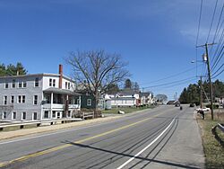
Daniel Webster Highway
|
|
| Country | United States |
| State | New Hampshire |
| County | Hillsborough |
| Town | Merrimack |
| Area | |
| • Total | 3.72 sq mi (9.63 km2) |
| • Land | 3.38 sq mi (8.74 km2) |
| • Water | 0.34 sq mi (0.89 km2) |
| Elevation | 98 ft (30 m) |
| Population
(2020)
|
|
| • Total | 5,176 |
| • Density | 1,533.18/sq mi (592.03/km2) |
| Time zone | UTC-5 (Eastern (EST)) |
| • Summer (DST) | UTC-4 (EDT) |
| Area code(s) | 603 |
| FIPS code | 33-21780 |
| GNIS feature ID | 1867352 |
East Merrimack is a special area in the town of Merrimack, New Hampshire, United States. It is called a census-designated place (CDP). This means it is a specific area that the government defines for counting people.
East Merrimack is not a separate town with its own center. Instead, it is a region within the larger town of Merrimack. It is located east of the F. E. Everett Turnpike. This area includes parts of other small communities like Reeds Ferry and Thornton's Ferry.
In 2020, about 5,176 people lived in East Merrimack. This was an increase from 4,197 people in 2010, showing that the area is growing.
Contents
Exploring East Merrimack's Location
East Merrimack is in the eastern part of the town of Merrimack. To its west is the Everett Turnpike, a major highway. To the east, the Merrimack River forms the border with Litchfield.
The area stretches north to the border of Bedford. To the south, it goes past a road called Star Drive.
Main Roads and Travel
U.S. Route 3 is the main road that runs through East Merrimack. This road can take you north about 10 miles (16 km) to Manchester. If you go south, it's about 7 miles (11 km) to Nashua.
You can also get onto the Everett Turnpike from East Merrimack. There are two main exits nearby:
- Exit 11 (Continental Boulevard) is closer to the southern part of the area.
- Exit 12 (Bedford Road) is near the northern end.
Land and Water Features
East Merrimack covers a total area of about 3.7 square miles (9.6 square kilometers). Most of this area is land, about 3.4 square miles (8.7 square kilometers).
About 0.3 square miles (0.9 square kilometers) of the area is water. Most of this water is part of the Merrimack River, which flows along the eastern edge.
Who Lives in East Merrimack?
The number of people living in East Merrimack has changed over the years.
- In 1980, there were 2,052 people.
- By 1990, the population grew to 3,656.
- In 2000, it was 3,784.
- In 2010, 4,197 people lived there.
- The most recent count in 2020 showed 5,176 residents.
Community Life
In 2010, there were 1,928 households in East Merrimack. A household means all the people living together in one home. About 27% of these households had children under 18 living with them.
The average household had about 2 people. The average family had about 3 people.
Age Groups in the Community
The people living in East Merrimack come from different age groups:
- About 20% of residents were under 18 years old.
- About 30% were between 25 and 44 years old.
- About 15% were 65 years old or older.
The median age in 2010 was 40 years. This means half the people were younger than 40, and half were older.
See also
 In Spanish: East Merrimack para niños
 | Kyle Baker |
 | Joseph Yoakum |
 | Laura Wheeler Waring |
 | Henry Ossawa Tanner |


