
East Ryde, New South Wales facts for kids
Quick facts for kids East RydeSydney, New South Wales |
|||||||||||||||
|---|---|---|---|---|---|---|---|---|---|---|---|---|---|---|---|

Lane Cove River where it passes East Ryde
|
|||||||||||||||
| Population | 2,454 (2016 census) | ||||||||||||||
| Postcode(s) | 2113 | ||||||||||||||
| Location | 12 km (7 mi) NW of Sydney CBD | ||||||||||||||
| LGA(s) | City of Ryde | ||||||||||||||
| State electorate(s) | Lane Cove | ||||||||||||||
| Federal Division(s) | Bennelong | ||||||||||||||
|
|||||||||||||||
East Ryde is a suburb of Sydney in New South Wales, Australia. It is part of the Northern Sydney region. East Ryde is located about 12 kilometers north-west of the Sydney city center. It is in the local government area of the City of Ryde. East Ryde sits on the western side of the Lane Cove River. It shares the postcode 2113 with the nearby suburb of North Ryde.
Contents
Location
East Ryde is a small, quiet suburb. It is surrounded by bushland and water on most sides. Most of East Ryde is on top of a ridge. This area was developed in 1960 and is known as the Dress Circle Estate. The parts of East Ryde near the Lane Cove River have views of mangrove wetlands. These areas often have large, modern homes.
Aboriginal Culture

The land between the Parramatta and Lane Cove Rivers was originally called Wallumatta by Aboriginal people. When the first European settlers arrived, many Aboriginal people were affected by new diseases. Their language, social systems, and traditions were mostly lost.
The Aboriginal name lives on in a local park called the Wallumatta Nature Reserve. This reserve is at the corner of Twin and Cressy roads. It is one of the last remaining areas of the Sydney Turpentine-Ironbark Forest. This type of forest is very rare and endangered in Sydney. The National Parks and Wildlife Service looks after this important reserve.
History
The area that is now East Ryde was once covered by Sydney Turpentine-Ironbark Forest. It was originally known as the 'North Ryde Dress Circle Estate'. This is because it was part of North Ryde before it became its own suburb.
East Ryde is bordered by Cressy Road, Coxs Road, the Lane Cove River, Strangers Creek, and Buffalo Creek. It was once part of the Field of Mars Common. This was an area set aside in 1804 by Governor King. It was used for breeding animals owned by early settlers.
In the late 1800s, there were plans to sell parts of the Field of Mars Common. The first land sale happened in 1885. This included land around Kittys Creek and what is now East Ryde. At this time, East Ryde was still part of North Ryde.
There were also plans for a tramway and a railway line. In 1884, a tram was proposed to run through Balmain and Gladesville. It would cross Strangers Creek and go along Pittwater Road. This tramway was never built.
In 1925, a railway line was planned between Eastwood and St Leonards. New homes were built along the proposed route. One of these was on a hill near a planned station. This area was called the Dress Circle Estate because of its high position. The plans for the railway were cancelled in 1929. After this, building in the estate stopped for a while.
The company Hooker Rex kept the name Dress Circle Estate. They named the streets after famous Australian performers. Some streets are named after opera singers like June Bronhill and Dame Nellie Melba. Others are named after actors such as Diane Cilento and Peter Finch. Comedians like Kitty Bluett and Roy Rene also have streets named after them.
On October 1, 1960, the Mayor of Ryde celebrated the successful development of the Dress Circle Estate. About 500 home sites were created, and 250 modern homes were built. Ryde East Public School opened in 1961 because the population grew.
In 2006, some residents tried to change the suburb's name. They thought a new name might increase house prices. Suggestions included Bel Air, Melba, and Wallumatta. However, most residents voted to keep the name East Ryde.
Landmarks and Features
Great North Walk
The Great North Walk is a long walking trail from Sydney to Newcastle. Part of this trail follows the Lane Cove River. It passes through East Ryde between Buffalo Creek and Magdala Park. Along the way, you can see mangrove communities at Buffalo Creek and Kittys Creek. There are boardwalks to help walkers explore these areas. Buffalo Creek Reserve also has picnic spots.
Schools
Ryde East Primary School is located on Twin Road. It has about 350 students. The school is featured in Ursula Dubosarsky's book "Jerry". The book is about an old horse that lived across from the school. The children at the school loved the horse very much.
Parks
- Heatley Reserve is in the East Ryde Shopping Centre complex.
- Brereton Park is bordered by Melba Drive, Bronhill Avenue, and Pittwater Road. It is named after John Le Gay Brereton.
Waterways
- Lane Cove River
- Stranger's Creek
- Kitty's Creek
Scout Halls
- 1st East Ryde, John Miller Street (Ryde)
- 3rd North Ryde, Cressy Road
Population
The 2016 census showed that 2,454 people lived in East Ryde. Most people (72.1%) were born in Australia. Also, 75.7% of people spoke only English at home. The most common backgrounds were Australian (23.3%), English (22.6%), and Irish (9.2%). For religion, the most common choices were Catholic (35.4%), No Religion (28.3%), and Anglican (13.4%). The average weekly household income was $2,585. This was much higher than the national average of $1,438.
Notable Residents
- Former professional rugby league footballer Steve Roach
- Former professional rugby league footballer Paul Sironen
Images for kids
-
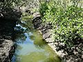
Kittys Creek, showing mangrove community
-
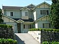
Home influenced by California Bungalow style, Coxs Road
-
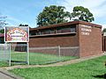
Christian Reformed Church, Coxs Road, with interesting sign
-
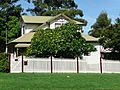
Weatherboard home, Cressy Road


