Eaton Canyon facts for kids
Quick facts for kids Eaton Canyon |
|
|---|---|

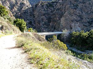
Eaton Canyon with toll road bridge in background
|
|
| Nearest city | Pasadena, California |
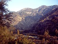
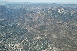
Eaton Canyon is a beautiful natural area in the San Gabriel Mountains in the Angeles National Forest, United States. It's a big canyon that starts near Mount Markham and San Gabriel Peak. The water from the canyon flows into the Rio Hondo river and then into the Los Angeles River. The canyon is named after Judge Benjamin S. Eaton, who lived nearby in 1865.
The most popular part of the canyon is the Eaton Canyon Nature Center in Pasadena, California. You can also find the start of the Mount Wilson Toll Road here. It's a great place to explore nature and go hiking!
Contents
Discovering Eaton Canyon's Past
Eaton Canyon sits at the base of the San Gabriel Mountains. Spanish settlers first called it "El Precipicio," which means "The Cliff," because of its steep sides. Different government groups manage parts of the canyon today.
A man named Benjamin Eaton was hired by Don Benito Wilson to bring water to a ranch called Fair Oaks. Later, in August 1877, a famous nature expert named John Muir visited the San Gabriel Mountains. He wrote about his trip, saying he stopped at Eaton Canyon because it was very hot and his new shoes hurt his feet.
Sadly, on October 27, 1993, a wildfire badly damaged the canyon floor and many nearby homes.
Exploring Eaton Canyon's Natural Wonders
Eaton Canyon Natural Area Park
The Eaton Canyon Natural Area Park is where the mountain stream meets the flatter land at the bottom of the San Gabriel Mountains. The Los Angeles County Department of Parks and Recreation manages most of this park. The natural area covers about 190 acres (0.8 square kilometers).
This park is special because its nature center has exhibits about the plants and animals that live in Southern California's San Gabriel Valley. The original center was destroyed by the 1993 fire, but it was rebuilt in 1998. About 40% of the water used in Pasadena and parts of Altadena comes from local sources, including the upper part of Eaton Canyon, which is managed by the City of Pasadena's Water Department.
- 34°10′38″N 118°05′49″W / 34.177233°N 118.097°W - Eaton Canyon Park
The Beautiful Eaton Canyon Falls
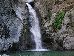
The main waterfall in Eaton Canyon is a beautiful fifty-foot drop where Eaton Creek flows. It's located north of the bridge, in the part of the canyon managed by the US Forest Service. John Muir once described this waterfall as "a charming little thing, with a low, sweet voice, singing like a bird." He said it poured into a "round mirror-pool."
There are also other waterfalls higher up in the canyon, but they are harder to reach. For a while, there was a tunnel that allowed access, but it was closed in 1979. There are no official trails to these upper falls anymore. It can be very dangerous to try and climb to them using unofficial paths. People have been seriously hurt trying to do this.
Because of safety concerns, the US Forest Service closed the trail to the upper falls on August 1, 2014. If you go into this closed area, you could face a large fine or even jail time. It's important to stay on marked trails for your safety.
- 34°11′48″N 118°06′10″W / 34.1966°N 118.1028°W - Eaton Canyon falls
Eaton Canyon Golf Course
The Eaton Canyon Golf Course is a 9-hole course with narrow paths and hilly ground. The Los Angeles County Department of Parks and Recreation also runs this course, which opened in 1962.
It was first planned to be an 18-hole course. A famous golf course designer named William Francis Bell (also known as Billy Bell, Jr.) designed it. When it opened, there was a special golf event with important people and local golf pros, including Jerry Barber, who won the PGA Championship in 1961.
- 34°09′57″N 118°06′16″W / 34.1658°N 118.1044°W - Eaton Canyon Park Golf Course
Mount Wilson Toll Road: A Historic Path
The Mount Wilson Toll Road was a historic road that went up Mount Wilson from 1891 to 1936. You could drive a car on it from the foothills in Altadena. It was once easy to get to from Pasadena by driving right up to the toll house. Today, you can still access the road from Pinecrest Drive in Altadena. A landslide in 2005 blocked part of the road, but it has since been fixed and reopened.
Mount Wilson has always been a busy place, even for the local Native American tribes. Benjamin Davis Wilson created a proper trail to the top of Mt. Wilson from Sierra Madre. The part of the Mt. Wilson Toll Road that goes to Henninger Flats is managed by the Los Angeles County Fire Department.
- 34°11′31″N 118°06′16″W / 34.19189°N 118.1044°W - Mt. Wilson Toll Road trail head
Eaton Wash: A Waterway's Journey
After leaving the foothills and flowing south, Eaton Creek becomes the Eaton Wash. This wash carries water into the Rio Hondo river and then into the Los Angeles River. Eaton Wash is one of the main streams in Altadena that helps fill the Raymond Basin, which is an underground water source. It's also one of the two main channels that carry storm water in Pasadena, the other being the Arroyo Seco.
On its way to the Rio Hondo, Eaton Wash is joined by water from Pasadena Glen and Hastings Canyons. These channels have been changed by flood control dams near the mountains. They have also been put into man-made channels or storm drains in their lower parts. Usually, Eaton Wash and Arroyo Seco don't carry much water.
- 34°04′10″N 118°03′22″W / 34.0694°N 118.056°W - Eaton Wash, USGS El Monte (CA)
Eaton Canyon Reservoir and Dam
The Eaton Wash Reservoir and the Eaton Wash Dam were built in 1937. They are managed by the Los Angeles County Department of Public Works. The dam is made of rock, is 63 feet (19 meters) tall, and 1545 feet (471 meters) long. The reservoir can normally hold 721 acre-feet (889,000 cubic meters) of water. It covers an area of 54 acres (220,000 square meters) and collects water from an area of 9.47 square miles (25 square kilometers). Its main purpose is to help control floods and store debris.
- 34°10′12″N 118°05′29″W / 34.17°N 118.09134°W - Eaton Canyon Reservoir
- 34°10′09″N 118°05′24″W / 34.1692°N 118.09°W - Eaton Wash Dam


