
Edinburg, New York facts for kids
Quick facts for kids
Edinburg
|
||
|---|---|---|
| Town of Edinburg | ||
|
||

Map highlighting Edinburg's location within Saratoga County.
|
||

Edinburg
Location in New York Adirondack Park
|
||
| Country | United States | |
| State | New York | |
| County | Saratoga | |
| Named for | Edinburgh, Scotland | |
| Area | ||
| • Total | 67.09 sq mi (173.77 km2) | |
| • Land | 60.17 sq mi (155.84 km2) | |
| • Water | 6.92 sq mi (17.94 km2) | |
| Elevation | 1,155 ft (352 m) | |
| Population
(2020)
|
||
| • Total | 1,333 | |
| • Density | 19.869/sq mi (7.6711/km2) | |
| Time zone | UTC-5 (Eastern (EST)) | |
| • Summer (DST) | UTC-4 (EDT) | |
| FIPS code | 36-23591 | |
| GNIS feature ID | 0978925 | |

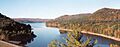
Edinburg is a small town in New York, located in the northwestern part of Saratoga County. It's nestled within the beautiful Adirondack Park. A special bridge, the Batchellerville Bridge, connects different parts of the town across the large Great Sacandaga Lake.
Contents
What's in a Name?
The town of Edinburg is named after the famous city of Edinburgh in Scotland. When it was first named, it was spelled Edinburgh. But in 1808, the spelling was changed to Edinburg.
A Look Back: Edinburg's History
Edinburg is found in the Adirondack Park, right on the shores of Great Sacandaga Lake. It's in the northwest part of Saratoga County.
Early Settlers
The first European settlers arrived in the Sacandaga River Valley around 1787. They came to an area called Fish House. One of the first families was Abijah Stark's, who moved from Coleraine, Massachusetts. Soon after, other families like the Andersons, West Cotts, Randall, and Bass families also settled here.
Many early settlers moved to this valley during the American Revolutionary War. They found the land was cheap, and there were good chances for a better life. This made it a great place to start a new home.
Settlement began on the west side of the river in the early 1790s. Families like the Sumner, Barker, Deming, and Partridge families moved there. On the east side, Batchellerville started to grow in the late 1790s and early 1800s. The Noyes, Gordon, Batcheller, and DeGolia families were among the first to settle there.
Becoming a Town
Edinburg was originally part of a larger area called the Town of Providence. But the area quickly grew with new settlers. In 1801, the people decided the town was big enough to have its own name. They called it Northfield at a meeting on March 13, 1801. However, in 1808, they found another Northfield in New York. So, they changed the name to Edinburgh.
The first official town meeting happened on April 7, 1801. At this meeting, they made some interesting rules. For example, they decided to raise $50.00 to help the town's poor. They also allowed hogs to roam freely!
In 1802, they updated the hog rule. Hogs could still roam, but they had to wear a strong collar called a "yoak." Also, male hogs over two months old were not allowed to roam freely from May to December. If a male hog was caught, the owner had to pay $1.00 or lose the hog.
Town Life and Work
For a long time, farming, logging, and making wooden items were the main jobs in Edinburg. Batchellerville became a busy manufacturing area with several large woodenware mills. The west side of the river was more focused on farming. However, Beecher's Hollow and Tennantville also had big sawmills and woodenware factories.
The town had many small communities, each with its own school and often a cemetery. Besides Beecher's Hollow and Batchellerville, some of these were Tennantville, Edinburgh Hill, Clarkville, Sand Hill, Cold Brook, Anderson, and Partridge Districts.
Industries did well until the early 1880s. Then, several fires destroyed many mills. About one-third of the people moved away to find new jobs.
In the early 1920s, the town lost even more people. This happened because a dam was going to be built that would flood the valley.
On March 27, 1930, the gates on the Conklingville Dam were closed. By 1931, the valley and the communities along the river were changed forever. The Sacandaga Reservoir was created, covering much of the old land.
Today, Edinburg is known for having one of the few covered bridges left in New York State. It's the only one left in Saratoga County. The reservoir was renamed The Great Sacandaga Lake in the 1960s. Now, hundreds of seasonal homes dot its shores. Only two original farms remain. Logging and tourism are the main industries today.
Geography of Edinburg
Edinburg covers about 67.1 square miles (173.77 square kilometers). Most of this is land, about 60.1 square miles (155.84 square kilometers). The rest, about 7.0 square miles (17.94 square kilometers), is water.
The town is split by the large Great Sacandaga Lake. The Batchellerville Bridge, which carries County Road 98, connects the two parts of the town across the lake. The western edge of the town borders Fulton County.
People of Edinburg
| Historical population | |||
|---|---|---|---|
| Census | Pop. | %± | |
| 1820 | 1,469 | — | |
| 1830 | 1,571 | 6.9% | |
| 1840 | 1,458 | −7.2% | |
| 1850 | 1,336 | −8.4% | |
| 1860 | 1,479 | 10.7% | |
| 1870 | 1,405 | −5.0% | |
| 1880 | 1,523 | 8.4% | |
| 1890 | 1,203 | −21.0% | |
| 1900 | 1,032 | −14.2% | |
| 1910 | 793 | −23.2% | |
| 1920 | 595 | −25.0% | |
| 1930 | 512 | −13.9% | |
| 1940 | 534 | 4.3% | |
| 1950 | 530 | −0.7% | |
| 1960 | 602 | 13.6% | |
| 1970 | 844 | 40.2% | |
| 1980 | 1,126 | 33.4% | |
| 1990 | 1,041 | −7.5% | |
| 2000 | 1,384 | 32.9% | |
| 2010 | 1,214 | −12.3% | |
| 2020 | 1,333 | 9.8% | |
| U.S. Decennial Census | |||
According to the census from 2010, there were 2,214 people living in Edinburg. These people made up 547 households. Most of the people (98.8%) were White.
About 17.7% of households had children under 18 living with them. The average household had about 2.22 people. The average age of people in Edinburg was 49.2 years old.
Communities and Places in Edinburg
- Batchellerville – A small community on the eastern side of the Great Sacandaga Lake. The Batchellerville Presbyterian Church is a historic building here.
- Clarkville – A community located northwest of Edinburg village. It is close to the western town line.
- Edinburg (also known as "Beechers Hollow") – This is a community on the western side of the Great Sacandaga Lake. The Barker General Store and the Eli and Diadama Beecher House are historic sites here.
- Fox Hill – A place found southeast of Batchellerville.
- Plateau Sky Ranch Airport (1F2) – A small airport with a grass runway. It is located northwest of Edinburg village.
- Tenantville – A community in the northern part of the town.
- Thousand Acre Swamp – A swampy area located east of Fox Hill.
- West Day – A community on the eastern border of the town.
Images for kids
-
Great Sacandaga Lake
See also
 In Spanish: Edinburg (Nueva York) para niños
