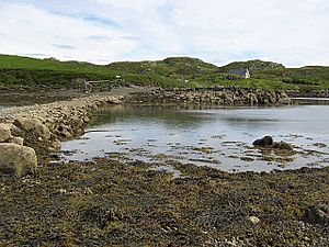
Eilean Chaluim Chille facts for kids
| Gaelic name | Calum Cille |
|---|---|
| Meaning of name | island of Saint Columba |
| OS grid reference | NB385215 |
| Coordinates | 58°07′N 6°26′W / 58.11°N 6.44°W |
| Physical geography | |
| Island group | Lewis and Harris |
| Area | 110 ha |
| Area rank | 144 |
| Highest elevation | Creag Mhor 43 m |
| Administration | |
| Sovereign state | United Kingdom |
| Country | Scotland |
| Council area | Na h-Eileanan Siar |
| Demographics | |
| Population | 0 |
Eilean Chaluim Chille is a small, uninhabited island in the Outer Hebrides. This group of islands is located off the west coast of Scotland. The island's name means "island of Saint Columba" in Gaelic.
Eilean Chaluim Chille lies off the east coast of Lewis, near the mouth of Loch Erisort. When the tide is low, the island connects to the mainland of Lewis at Crobeag. You can walk across a natural causeway to reach it.
Contents
Exploring Eilean Chaluim Chille's Past
At the southern end of Eilean Chaluim Chille, you can find the ruins of St Columba's Church. This church was once a very important religious place. Old records from 1549 show it was the main church for the area of Lochs.
The Legacy of Saint Columba
People believe there has been a church on this spot since about 800 AD. It was likely built by followers of Saint Columba. Saint Columba was a famous Irish monk who helped spread Christianity in Scotland. He died on the island of Iona in 597 AD.
A Historic Burial Ground
The church also had a cemetery that was used for many years. People continued to bury their loved ones there until 1878. Today, Eilean Chaluim Chille is protected by Historic Scotland. This means it is recognized as an important ancient monument.
See also
 In Spanish: Eilean Chaluim Chille para niños
 | Calvin Brent |
 | Walter T. Bailey |
 | Martha Cassell Thompson |
 | Alberta Jeannette Cassell |


