El Ejido facts for kids
Quick facts for kids
El Ejido
|
|||
|---|---|---|---|
 |
|||
|
|||
| Country | |||
| Community | |||
| Province | |||
| Comarca | Poniente Almeriense | ||
| Area | |||
| • Total | 227 km2 (88 sq mi) | ||
| Elevation | 80 m (260 ft) | ||
| Population
(2018)
|
|||
| • Total | 84,710 | ||
| • Density | 373.2/km2 (966.5/sq mi) | ||
| Demonym(s) | Ejidense | ||
| Time zone | UTC+1 (CET) | ||
| • Summer (DST) | UTC+2 (CEST) | ||
| Website | elejido.org | ||
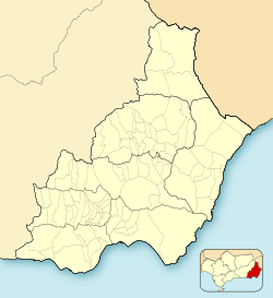
El Ejido is a city in the Province of Almería, located in the region of Andalusia, Spain. It is about 32 kilometers (20 miles) from the city of Almería. The city covers an area of 227 square kilometers (88 square miles). In 2014, about 84,144 people lived there.
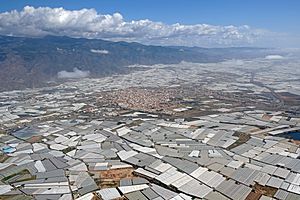
El Ejido is a major center for growing fruit and vegetables. Many people come here to work in the greenhouses. Some of these greenhouses use modern computer-controlled systems. These systems, called hydroponics, help save water and improve how much food is grown.
Near the city, along the coast, you'll find Almerimar. This is a popular spot for tourists and for people who want to relax by the sea.
Contents
A Look at El Ejido's History
The area around El Ejido has been settled for a very long time. The oldest discoveries come from the Copper Age. People also lived here during the Bronze Age and the time of Roman Hispania. Back then, it was known as the city of Murgi.
From the Middle Ages to Modern Times
During the Middle Ages, El Ejido was part of a larger area called Taha de Dalías. The flat lands were used for grazing sheep and goats. Water systems like cisterns and irrigation ditches were built in the 13th and 14th centuries.
After the Granada War in the 16th century, the area was not very populated. This was partly due to threats from pirates. By the mid-1700s, El Ejido was mostly small farms and grazing lands.
In 1953, a plan was approved to help people settle in the Campo de Dalías area. New towns like San Agustín and Las Norias de Daza were created. By the mid-20th century, El Ejido had just over 3,000 people.
The Rise of Greenhouses
A big change happened in the 1960s. Farmers started using a new method called "sanding" for greenhouse farming. They also began using drip irrigation, a water-saving system invented in Israel. These new ideas helped farming in El Ejido grow very quickly.
El Ejido became a leader in intensive agriculture in the province. This led to a lot of jobs and made the area very successful. This period was part of Spain's fast economic growth.
In 1981, El Ejido became the main town of its municipality. The towns of Dalías and Celín later became their own separate municipalities in 1982.
Today, the greenhouse areas of El Ejido and nearby regions are known as La Huerta de Europa (The Garden of Europe). They are also called El Mar de Plastico (The Sea of Plastic). This is because the huge number of greenhouses can even be seen from space by NASA!
Important Events in Recent History
In February 2000, the town experienced a period of social unrest. This led to protests and some damage in the area.
El Ejido's Climate
El Ejido has a hot, semi-desert climate. This means it gets a lot of sunshine and not much rain.
- Winters are usually mild, and temperatures often stay above 20°C (68°F). It rarely gets very cold.
- Summers are hot, with temperatures often going above 32°C (90°F). Nights can also be warm, around 22°C (72°F).
- Rainfall is very low throughout the year. El Ejido is one of the driest cities in Spain and Europe.
The average yearly temperature in El Ejido has been over 20°C (68°F) for the last 20 years. This makes it one of the warmest places in mainland Spain.
| Climate data for El Ejido (2003-2024) | |||||||||||||
|---|---|---|---|---|---|---|---|---|---|---|---|---|---|
| Month | Jan | Feb | Mar | Apr | May | Jun | Jul | Aug | Sep | Oct | Nov | Dec | Year |
| Record high °C (°F) | 26.7 (80.1) |
27.8 (82.0) |
31.9 (89.4) |
32.7 (90.9) |
35.9 (96.6) |
38.2 (100.8) |
39.4 (102.9) |
39.9 (103.8) |
40.3 (104.5) |
32.9 (91.2) |
30.5 (86.9) |
27.2 (81.0) |
40.3 (104.5) |
| Mean daily maximum °C (°F) | 18.4 (65.1) |
18.8 (65.8) |
20.5 (68.9) |
22.6 (72.7) |
25.8 (78.4) |
29.7 (85.5) |
32.4 (90.3) |
32.6 (90.7) |
29.6 (85.3) |
26.2 (79.2) |
21.6 (70.9) |
19.2 (66.6) |
24.8 (76.6) |
| Daily mean °C (°F) | 13.8 (56.8) |
14.3 (57.7) |
15.8 (60.4) |
17.9 (64.2) |
20.9 (69.6) |
24.6 (76.3) |
27.3 (81.1) |
27.7 (81.9) |
25.0 (77.0) |
21.6 (70.9) |
17.1 (62.8) |
14.8 (58.6) |
20.1 (68.1) |
| Mean daily minimum °C (°F) | 9.2 (48.6) |
9.7 (49.5) |
11.2 (52.2) |
13.2 (55.8) |
15.9 (60.6) |
19.4 (66.9) |
22.1 (71.8) |
22.8 (73.0) |
20.3 (68.5) |
17.0 (62.6) |
12.6 (54.7) |
10.3 (50.5) |
15.3 (59.6) |
| Record low °C (°F) | −1.2 (29.8) |
2.7 (36.9) |
4.2 (39.6) |
8.2 (46.8) |
9.4 (48.9) |
14.2 (57.6) |
16.2 (61.2) |
15.9 (60.6) |
14.2 (57.6) |
9.5 (49.1) |
6.7 (44.1) |
5.1 (41.2) |
−1.2 (29.8) |
| Average precipitation mm (inches) | 24.3 (0.96) |
24.8 (0.98) |
34.4 (1.35) |
22.3 (0.88) |
13.5 (0.53) |
3.4 (0.13) |
0.5 (0.02) |
4.1 (0.16) |
14.4 (0.57) |
24.7 (0.97) |
35.4 (1.39) |
41.1 (1.62) |
242.9 (9.56) |
| Source: Agencia Estatal de Meteorologia AEMET OpenData 6291B (May 2003- Jun 2024) | |||||||||||||
Getting Around: Transport
El Ejido is one of the biggest towns in Spain that doesn't have a train station. In 2020, there was a plan to build a railway line. This line would connect Almería to Adra, passing through Roquetas de Mar and El Ejido. The mayor of El Ejido, Francisco Góngora, has said he supports this project.
How Many People Live Here: Demographics
Here's how the population of El Ejido has changed over the years:
| Historical population | ||
|---|---|---|
| Year | Pop. | ±% |
| 1999 | 51,485 | — |
| 2000 | 53,008 | +3.0% |
| 2001 | 55,710 | +5.1% |
| 2002 | 57,063 | +2.4% |
| 2003 | 61,265 | +7.4% |
| 2004 | 63,914 | +4.3% |
| 2005 | 68,828 | +7.7% |
| 2010 | 85,389 | +24.1% |
| Source: INE (Spain) | ||
Sports in El Ejido
The local football team is called CD El Ejido 2012. They are based in the municipality.
See also
 In Spanish: El Ejido para niños
 | Lonnie Johnson |
 | Granville Woods |
 | Lewis Howard Latimer |
 | James West |


