Eola Hills facts for kids
Quick facts for kids Eola Hills |
|
|---|---|

Eola Hills
|
|
| Highest point | |
| Elevation | 1,170 ft (360 m) |
| Geography | |
| Country | United States |
| State | Oregon |
| District | Yamhill County |
| Range coordinates | 45°4′31.425″N 123°7′25.362″W / 45.07539583°N 123.12371167°W |
| Topo map | USGS Mission Bottom |
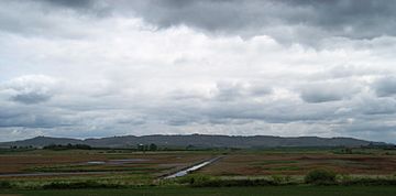
The Eola Hills are a group of rolling hills located in Oregon, United States. You can find them just northwest of the city of Salem. These hills stretch for about 10 miles (16 kilometers) from the small community of Eola all the way north into Yamhill County.
Contents
Where Are the Eola Hills?
The Eola Hills are found in the beautiful state of Oregon, in the United States. They are located to the northwest of Salem, which is the capital city of Oregon. These hills are part of Polk County and Yamhill County.
How Are They Divided?
The Eola Hills are separated from another group of hills, the Salem Hills. The Willamette River flows between them near the community of Eola. This river acts like a natural border, keeping the two hill ranges apart.
What is a Hill Range?
A hill range is a series of hills that are connected. They often form a long line or group. The Eola Hills are a good example of this, as they stretch out over several miles.
Geography of the Eola Hills
The Eola Hills reach an elevation of about 1,170 feet (357 meters) above sea level. This makes them a noticeable feature in the landscape. The area is known for its gentle slopes and green scenery.
What is the Willamette River?
The Willamette River is a major river in Oregon. It flows north through the Willamette Valley, which is a very fertile area. This river is important for the geography of the region, including how the Eola Hills are shaped.
Fun Facts About the Area
The region around the Eola Hills is famous for its farms and vineyards. Many people visit to enjoy the natural beauty and local products. The hills provide good views of the surrounding valley.
 | Stephanie Wilson |
 | Charles Bolden |
 | Ronald McNair |
 | Frederick D. Gregory |


