Ephrata, Washington facts for kids
Quick facts for kids
Ephrata, Washington
|
|
|---|---|

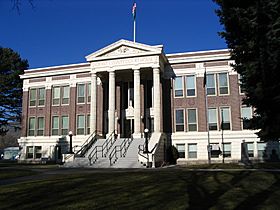
Grant County Courthouse in Ephrata, pictured in 2008
|
|

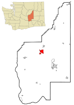
Location of Ephrata, Washington
|
|
| Country | United States |
| State | Washington |
| County | Grant |
| Government | |
| • Type | Mayor–council |
| Area | |
| • Total | 10.44 sq mi (27.03 km2) |
| • Land | 10.44 sq mi (27.03 km2) |
| • Water | 0.00 sq mi (0.00 km2) |
| Elevation | 1,276 ft (389 m) |
| Population
(2020)
|
|
| • Total | 8,477 |
| • Estimate
(2021)
|
8,477 |
| • Density | 779.61/sq mi (301.00/km2) |
| Time zone | UTC-8 (PST) |
| • Summer (DST) | UTC-7 (PDT) |
| ZIP Code |
98823
|
| Area code | 509 |
| FIPS code | 53-22080 |
| GNIS feature ID | 1512192 |
Ephrata is a city in Washington State, United States. It is the main city, also known as the county seat, of Grant County. In 2020, about 8,477 people lived there.
Contents
History of Ephrata
Ephrata became an official city on June 21, 1909. At the same time, it was chosen as the county seat for the new Grant County.
How Ephrata Got Its Name
The name Ephrata is thought to have been given by someone who worked for the Great Northern Railway. The name comes from an old story about an orchard in the middle of a desert. It is also an ancient name for the town of Bethlehem.
Early Days and Horse Trading
Before it was a city, the area was known as Beezley Springs. This was because a horse rancher named Frank Beezley settled near some natural springs in 1886. For a long time, not many people lived here because the land was very dry.
In the early 1900s, many wild horses roamed the land around Ephrata. Trading horses was a big part of the local economy. Ephrata was the main place for gathering these horses. The very last "Grand Horse Round-up" happened in Ephrata in 1906. After that, Ephrata became a center for trading cattle and sheep.
Ephrata's Airport and Movies
In 1939, one of Washington state's longest airport runways was built in Ephrata. It was used by the U.S. Army Air Corps until 1945. After the war, it became a regular airport for planes.
This airport was even used in a movie! It appeared in the 1989 film Always, which was the last movie for actress Audrey Hepburn. The airport scenes in the movie were filmed right here in Ephrata.
A Big Lottery Win
In January 2011, something very exciting happened in Ephrata. A man named Jim McCullar bought a Mega Millions lottery ticket at a Safeway store. He won half of a $380 million jackpot! This was one of the biggest lottery wins in U.S. history at the time.
The Columbia Basin Irrigation Project
Starting in 1918, people in Ephrata began to push for a big plan. They wanted to bring water from the Columbia River to irrigate, or water, the dry but fertile land nearby. This plan was called "The Dam University" because Ephrata residents worked hard to get support for it.
The first money for the Grand Coulee Dam came from a program called the Public Works Administration. This program was part of President Franklin Roosevelt's "New Deal" in 1933. However, the water for irrigation was not released right away. During the 1940s, the country was focused on World War II. The Grand Coulee Dam mainly produced electricity for making things like aluminum for military aircraft. After the war ended, the project went back to its main goal: watering the desert.
How Ephrata's Population Grew
Because of the Irrigation Project and military activities, Ephrata's population grew a lot. It became eight times bigger between 1940 and 1960! After these big projects slowed down, the town's population went down for a while. But since 1990, Ephrata has been growing steadily.
Geography and Climate
Ephrata is located at 47°19′1″N 119°32′53″W / 47.31694°N 119.54806°W. The city covers about 10.09 square miles (27.03 square kilometers) of land. There is no water area within the city limits.
Ephrata has a semi-arid climate. This means it is usually dry, but not a full desert.
| Climate data for Ephrata, Washington | |||||||||||||
|---|---|---|---|---|---|---|---|---|---|---|---|---|---|
| Month | Jan | Feb | Mar | Apr | May | Jun | Jul | Aug | Sep | Oct | Nov | Dec | Year |
| Record high °F (°C) | 61 (16) |
65 (18) |
75 (24) |
94 (34) |
101 (38) |
107 (42) |
109 (43) |
115 (46) |
106 (41) |
86 (30) |
72 (22) |
63 (17) |
115 (46) |
| Mean daily maximum °F (°C) | 34 (1) |
42 (6) |
54 (12) |
64 (18) |
73 (23) |
81 (27) |
88 (31) |
88 (31) |
78 (26) |
63 (17) |
45 (7) |
34 (1) |
62 (17) |
| Mean daily minimum °F (°C) | 22 (−6) |
27 (−3) |
33 (1) |
40 (4) |
48 (9) |
55 (13) |
61 (16) |
60 (16) |
51 (11) |
40 (4) |
30 (−1) |
23 (−5) |
41 (5) |
| Record low °F (°C) | −22 (−30) |
−24 (−31) |
2 (−17) |
22 (−6) |
28 (−2) |
33 (1) |
40 (4) |
36 (2) |
28 (−2) |
8 (−13) |
0 (−18) |
−15 (−26) |
−24 (−31) |
| Average precipitation inches (mm) | 0.83 (21) |
0.78 (20) |
0.75 (19) |
0.43 (11) |
0.64 (16) |
0.51 (13) |
0.44 (11) |
0.25 (6.4) |
0.37 (9.4) |
0.47 (12) |
1.03 (26) |
1.19 (30) |
7.69 (195) |
| Source: The Weather Channel | |||||||||||||
Population Information
| Historical population | |||
|---|---|---|---|
| Census | Pop. | %± | |
| 1910 | 323 | — | |
| 1920 | 628 | 94.4% | |
| 1930 | 516 | −17.8% | |
| 1940 | 951 | 84.3% | |
| 1950 | 4,589 | 382.5% | |
| 1960 | 6,548 | 42.7% | |
| 1970 | 5,255 | −19.7% | |
| 1980 | 5,359 | 2.0% | |
| 1990 | 5,349 | −0.2% | |
| 2000 | 6,808 | 27.3% | |
| 2010 | 7,664 | 12.6% | |
| 2020 | 8,477 | 10.6% | |
| 2021 (est.) | 8,477 | 10.6% | |
| U.S. Decennial Census 2020 Census |
|||
Ephrata in 2010
In 2010, Ephrata had 7,664 people living in 2,856 households. About 36% of households had children under 18. Nearly half (49.6%) were married couples.
Most people in Ephrata (84.1%) were White. About 16.7% of the population was Hispanic or Latino. The average age of people in the city was 34.7 years old. About 27.4% of residents were under 18 years old.
Schools in Ephrata
Ephrata has several schools for students of all ages.
Elementary Schools
- Columbia Ridge Elementary
- Grant Elementary
Intermediate Schools
- Parkway Intermediate School
Middle Schools
- Ephrata Middle School
Private Schools
- New Life Christian School
- St. Rose Of Lima Catholic School
High Schools
- Ephrata High School
Getting Around Ephrata
Ephrata is connected by several roads and transportation options.
State Route 28 goes through Ephrata, connecting it to cities like Wenatchee and Soap Lake. Another road, State Route 282, links up with State Route 17 for travel towards Moses Lake.
The city also has the Ephrata Municipal Airport. This airport is used for some cargo flights and for smaller private planes. The BNSF Railway tracks run through Ephrata, mostly for freight trains. However, the Empire Builder, an Amtrak passenger train, also stops at the Ephrata station. For local travel, the Grant Transit Authority offers bus service that connects Ephrata to Soap Lake and Moses Lake.
Famous People From Ephrata
- Danica Dart, a racing driver
- Ken Dow, a professional American football player
- Shane Johnson, an actor
- Robert K. Preston, a helicopter pilot
- Bobby Rich, a radio broadcaster
- Baxter Ward, a TV news anchor
- Jim Wickwire, a mountaineer and lawyer
See also
 In Spanish: Ephrata (Washington) para niños

