Etzanoa facts for kids

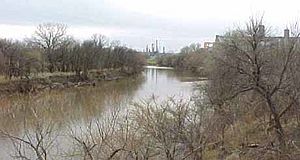
Walnut River, Arkansas City, Kansas
|
|
| Lua error in Module:Location_map at line 420: attempt to index field 'wikibase' (a nil value). | |
| Alternative name | Tzanoa |
|---|---|
| Location | Arkansas City, Kansas, United States |
| Region | Great Plains |
| Type | Settlement |
| Length | about 5 miles long |
| History | |
| Founded | c. 1450 |
| Abandoned | c. 1700 |
| Cultures | Wichita people |
| Site notes | |
| Archaeologists | Donald Blakeslee |
| Public access | Accessible to the public. |
Etzanoa was a large, historic city built by the Wichita people. It was located in what is now Arkansas City, Kansas, near the Arkansas River. This city thrived between the years 1450 and 1700.
Spanish explorers called Etzanoa "the Great Settlement." They believed it might have been home to as many as 20,000 Wichita people. Etzanoa is considered part of a larger area known as Quivira.
In 1541, a Spanish explorer named Francisco Vásquez de Coronado visited central Kansas. He called the Wichita settlements "Quivira." Later, other Spanish expeditions came to Etzanoa. The Umana and Leyba expedition visited in 1594, and Juan de Oñate came in 1601.
These explorers called the people living there the "Rayados." In Spanish, Rayados means "striped." The Wichita people were known for the straight lines they tattooed on their faces and bodies.
The exact spot of Etzanoa was a mystery for a long time. Then, in April 2017, a local teenager found a cannonball. This cannonball was linked to a battle that happened in 1601 near present-day Arkansas City. Researchers used this important discovery to finally figure out where Etzanoa was located.
Contents
Discovering Etzanoa: Archaeological Finds

Donald Blakeslee, an archaeologist from Wichita State University, has led much of the recent research on Etzanoa. In 2013, historians at the University of California, Berkeley, re-read old Spanish accounts. These clearer translations helped Blakeslee match the written descriptions to actual places. He was able to find the 1601 Spanish battle site in Arkansas City.
Many artifacts have been found in the area. In 1994, thousands of items were uncovered during road construction. People living in Arkansas City often find things like pieces of pottery or flint tools. Robert Hoard, the Kansas State Archaeologist, is also studying sites in Rice and McPherson Counties.
Archaeologists have found more than a dozen large settlements. These sites stretch for about six miles along the Walnut River. They are located upstream from where the Walnut River joins the Arkansas River. These places are called the Lower Walnut focus sites. People lived in these sites from about 1500 to 1720. Some Spanish artifacts have also been discovered there.
The Rayados likely left the Walnut River area in the early 1700s. They might have moved south to Kay County, Oklahoma. Two Wichita archaeological sites from the 1700s, Deer Creek and Bryson Paddock, are known there. By then, their numbers seemed much smaller. This was possibly due to European diseases, wars, and people being captured and traded by others. The descendants of the Rayados eventually became part of the larger Wichita tribe.
In 2020, Donald Blakeslee used aerial surveys to find something new. He discovered a possible ceremonial site for Etzanoa near the other sites. It has a large circular ditch, about two meters wide and 50 meters across.
Who Were the Rayado Indians?
Archaeologists and historians believe the Rayado Indians spoke a Caddoan language. They were likely a sub-tribe of the Wichita people. Many things point to this idea. Their grass houses, how their settlements were spread out, and their chief named Catarax (which was a Wichita title) all match descriptions of the Wichita. They also stored their crops in large granaries, just like the Wichita.
Because they were Wichitas, the Rayados were related to the people Coronado had met in Quivira 60 years earlier. One linguist, Nancy Parrott Hickerson, had a different idea. She thought they might have been "Jumanos." However, "Jumano" seems to have been a general term for Plains Indians who painted or tattooed their faces, which fits the Rayados.
Both Jusepe's and Oñate's accounts say the Rayados were very numerous. Oñate estimated there were over 1,200 houses in the settlement. If these houses were as large as those of later Wichita tribes, this means at least 12,000 people lived there. Chief Catarax also told the Spanish explorers that there were more settlements upstream and on other rivers. The Rayados may have left their settlement when Oñate arrived because they had bad experiences with the Spanish before.
Spanish Explorers' Stories
Jusepe's Journey: 1594-1595
In 1594 or 1595, Antonio Gutierrez de Umana and Francisco Leyba de Bonilla led an expedition. This was the first known Spanish trip to the Great Plains of Oklahoma and Kansas in over 50 years. An Indigenous Mexican named Jusepe Gutierrez was the only survivor of this journey.
Jusepe said they left New Mexico and traveled east and north for more than a month. They found a "very large settlement." He described it as stretching over 26 miles along a river and being two miles wide. The houses had straw roofs and were built close together. But between groups of houses, there were fields of corn, squash, and beans. The Native people were many, but they "received the Spanish peacefully." They also gave the explorers plenty of food. Jusepe also saw a "multitude" of bison in the area. These people were likely the same ones later called "Rayados."
Oñate's Expedition: 1601
In 1601, Juan de Oñate, who founded and governed New Mexico, led his own expedition. He followed the path of Leyba and Umana. Jusepe guided Oñate, along with more than 70 Spanish soldiers and priests. There were also many Native American soldiers and servants, plus 700 horses and mules.
Oñate met Apache Indians in the Texas Panhandle. Later, he found a large camp of Escanjaques. The Escanjaques showed him the way to a big settlement about 30 miles away. Oñate called these people "Rayados," meaning "striped" in Spanish. This referred to their custom of painting or tattooing their faces. The Escanjaques were enemies of the Rayados. They tried to get the Spanish to attack the Rayados, claiming they were responsible for the deaths of Leyba and Umana years earlier.
The Escanjaques led Oñate to a nearby river, probably the Arkansas. There, they saw a few hundred Rayados on a hill. The Rayados came forward, throwing dirt in the air. This was a sign that they were ready for war. Oñate showed that he did not want to fight and made peace with the group. The Rayados turned out to be friendly and generous. Oñate said that, unlike the Escanjaques, the Rayados were "united, peaceful, and settled." They respected their chief, named Catarax. Oñate kept Catarax as a guide and a hostage, though he treated him well.
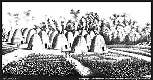
Catarax led Oñate and the Escanjaques across the Arkansas River. They went to a settlement on the eastern bank, a few miles from the river. The settlement was empty, as the people had fled. It had "more than twelve hundred houses." All of them were built along the bank of "another good-sized river which flowed into the large one" (probably the Arkansas). The Rayados' settlement was similar to what Coronado had seen in Quivira 60 years before. The homes were spread out. The houses were round, thatched with grass, and surrounded by large buildings to store corn, beans, and squash. Oñate stopped his Escanjaque guides from looting the town and sent them home. The Rayados bravely rescued Catarax, who had been chained.
The next day, Oñate and his army continued through the settlement for about eight miles. They did not see many Rayados. However, the Spanish were warned that the Rayados were gathering an army to attack them. Oñate decided it was safer to turn back. He thought he would need 300 Spanish soldiers to fight the Rayados. So, he turned his soldiers around and headed back to New Mexico.
Oñate feared an attack from the Rayados. But it seems the Escanjaques were the ones who attacked as Oñate's group returned to New Mexico. Oñate claimed many Escanjaques were killed in the battle, but many of his soldiers were also wounded. After two hours, Oñate stopped the fight, left the field, and led his group back to New Mexico.
An Escanjaque captured by Oñate, later named Miguel, drew a map of the region for the Spanish. He called the "Great Settlement" of the Rayados, "Etzanoa" or "Tzanoa."
Visiting Etzanoa Today
You can arrange limited private tours of the Etzanoa site. These tours can be set up through the Cherokee Strip Land Run Museum in Arkansas City. There are also plans to build a visitor's center for the site.
 | Delilah Pierce |
 | Gordon Parks |
 | Augusta Savage |
 | Charles Ethan Porter |

