
Walnut River (Kansas) facts for kids
Quick facts for kids Walnut River |
|
|---|---|

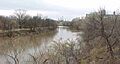
The Walnut River near Arkansas City, Kansas
|
|
| Other name(s) | Little Verdigris River |
| Country | United States |
| State | Kansas |
| Cities | Arkansas City, Winfield, El Dorado |
| Physical characteristics | |
| Main source | Near Cassoday, Kansas, United States 1,473 ft (449 m) 38°01′17″N 096°33′12″W / 38.02139°N 96.55333°W |
| River mouth | Arkansas River Near Arkansas City, Kansas, United States 1,043 ft (318 m) 37°02′57″N 097°00′02″W / 37.04917°N 97.00056°W |
| Length | 154 mi (248 km), North-South |
| Basin features | |
| River system | Arkansas River watershed |
The Walnut River is a river in Kansas, United States. It flows for about 154 miles (248 km). This river is a tributary, which means it flows into a larger river. The Walnut River joins the Arkansas River.
The Arkansas River then flows into the Mississippi River. This makes the Walnut River part of the huge watershed of the Mississippi River. The river was also once known as the "Little Verdigris River".
Contents
Where the Walnut River Flows
The Walnut River starts in the northern part of Butler County. It generally flows south through Butler and Cowley Counties. Along its path, it passes by several towns. These towns include El Dorado, Augusta, Winfield, and Douglass.
Finally, the Walnut River meets the Arkansas River near Arkansas City. Two important smaller rivers flow into the Walnut River. The Whitewater River joins it near Augusta. The Little Walnut River joins it in southern Butler County.
The River's Surroundings
The area drained by the Walnut River is called its drainage basin. This basin covers about 2,380 square miles (6,164 square kilometers). It is a region with rocky, rolling hills and open grasslands called prairie. The land here is between 1,050 and 1,625 feet (320 to 495 meters) high.
The area gets about 32 to 38 inches (81 to 97 cm) of rain each year. Most of this rain falls during the summer. The most common plant life is Tallgrass prairie, covering 66 percent of the land. Farms use 23 percent of the land for crops. Woodlands cover about five percent. Farmers mostly grow wheat, soybeans, cotton, hay, sorghum, and corn. Raising cattle is also very important here.
Lakes and Fun Activities
Upstream from El Dorado, there is a large dam built by the United States Army Corps of Engineers. This dam creates El Dorado Lake. A state park has been set up around this lake. The lake itself is about 8,000 acres (3,237 hectares) big. Another 8,000 acres of land around the lake are used for the park and for wildlife.
Another big lake in the Walnut River area is Winfield City Lake. It has about 1,250 acres (506 hectares) of water. It is surrounded by 1,150 acres (465 hectares) of parkland. Both El Dorado Lake and Winfield City Lake offer many fun things to do. You can go fishing, boating, hunting, and camping. They are also great places to watch wildlife.
In Winfield, there's an old dam called Tunnel Mill Dam. The east side of this dam is a public spot where people can fish. It's close to the old Kickapoo Corral. The west side of the dam and the Kickapoo Corral are private property, so they are not open to the public.
Historical Places
Near where the Walnut River meets the Arkansas River, close to Arkansas City, there are many important archaeological sites. One of these is the historical city of Etzanoa. This was a large settlement of the Wichita people. It was a busy city between 1450 and 1700 and had about 20,000 people living there.
A Spanish governor from New Mexico, named Juan de Oñate, visited this site in 1601.
Festivals
The Walnut Valley Festival is a well-known event. It takes place every year along the banks of the Walnut River in Winfield.
Images for kids
-
The Walnut River near Arkansas City, Kansas
See also
 In Spanish: Río Walnut (Kansas) para niños
