Eva site facts for kids

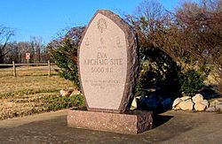
Eva Monument at Eva Beach
|
|
| Location | Benton County, Tennessee, |
|---|---|
| Region | Benton County, Tennessee |
| Coordinates | 36°4′29.17″N 87°58′59.34″W / 36.0747694°N 87.9831500°W |
| History | |
| Cultures | Archaic period |
| Site notes | |
| Excavation dates | 1940 |
The Eva site (also called 40BN12) is an ancient Native American place in Benton County, Tennessee, in the southeastern part of the United States. It was built next to an old path of the Tennessee River. People lived here for a long time during the Middle and Late Archaic period, from about 6000 to 1000 BC.
Scientists found many layers of soil here. These layers helped them discover three different ancient cultures. The oldest one was first found at Eva, so it's called the "Eva culture" or "Eva phase."
Today, the Eva site is underwater. It's covered by Kentucky Lake, a big lake made when the Tennessee River was dammed by Kentucky Dam. In 1940, before the dam was finished, University of Tennessee archaeologists dug up the site. They found a lot of information and artifacts. Thomas Lewis and Madeline Kneburg Lewis studied these finds. They shared what they learned in a book called Eva, an Archaic Site in 1961.
Contents
Where is the Eva Site Located?
The Tennessee River flows north through Benton County, Tennessee. It travels almost 100 miles (160 km) before joining the Ohio River. Kentucky Dam, which is about 80 miles (130 km) downstream from the Eva site, was finished in 1944. This dam created Kentucky Lake, which covers most of the state from north to south.
Hills on the western edge of the Highland Rim rise up to 300 feet (91 m) above the river. The Eva site is named after the town of Eva, which is about 2 miles (3.2 km) to the southwest.
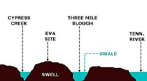
Before Kentucky Lake was made, the Eva site was on a flat area of land. This area stretched for almost 2 miles (3.2 km) between the river and the hills to the west. The Eva site was on a raised area of land. This raised area was between two old river channels. In ancient times, the Tennessee River flowed through one of these channels, about a mile west of where it was later.
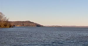
The Tennessee Valley Authority (TVA) manages Kentucky Lake. Much of the land around the lake near the Eva site is now part of Nathan Bedford Forrest State Park. You can see the submerged Eva site from Pilot Knob to the north. You can also see it from the Eva Beach boat ramp to the south. In 1993, a local group put up a small monument at Eva Beach. It reminds people about the Eva site's importance in ancient times.
What Did Archaeologists Find at Eva?
The University of Tennessee and the Works Progress Administration (WPA) dug at the Eva site. They worked from September 11 to November 23, 1940. The archaeologists found six layers of soil. The top layer was disturbed by farming. The other layers were called Strata I through V, with Stratum V being the deepest.
Big Sandy Culture (Stratum I and Plowzone)
The top layer and Stratum I held tools and items from the Big Sandy culture. These people lived at the Eva site from about 2000 to 1000 BC. They might have stayed as late as 500 BC.
Three Mile Culture (Stratum II)
Stratum II contained items from the Three Mile culture. This Middle Archaic group lived at Eva around 4000 to 2000 BC.
Unoccupied Period (Stratum III)
Stratum III had very few cultural items. This means the Eva site was probably empty for a while around 4000 BC.
Eva Culture (Strata IV and V)
Strata IV and V contained items from the Eva culture. This culture was first found at this site. The Eva culture was active at the site by 5200 BC. They might have lived there as early as 6000 BC.
Tools and Artifacts
Archaeologists found many tools made from flint and chert at Eva. These included projectile points (like spearheads), blades, and tools for butchering animals. Stone tools found were atlatl weights (used for throwing spears), gorgets (decorative neck pieces), and pestles (for grinding food).
They also found tools made from bone. These included awls (for piercing), needles, and fishhooks. One necklace made of snake bones was also found. Tools made from deer antlers included scrapers, projectile points, and atlatl hooks.
Human and Animal Burials
Archaeologists found 180 human burials at the Eva site. These included 29 babies, 11 children, 7 teenagers, and 133 adults. Most adults were younger than 45 years old. However, a few lived to be over 70. Studies of the human remains showed that the ancient people at Eva were healthy. They were healthier than later cultures in the area. Besides human burials, 18 dog burials were also found at the Eva site.
Who Lived at the Eva Site?
While some very old tools (like Clovis points) have been found nearby, people didn't start living at the Eva site in large numbers until about 6000 BC. This was during the Middle Archaic period. Many people continued to live at Eva until at least 1000 BC, and possibly until 500 BC.
Later, during the Woodland period and Mississippian period, some pottery pieces were found. But there weren't many of them. The Eva site was empty when European explorers and settlers arrived in the late 1700s. However, two important Native American trails met just south of the site.
The Eva Culture (6000-4000 BC)
Items found in Strata IV and V belong to the Eva culture. These include mussel shells, fire-cracked rocks, flint chips, antler tools, and animal bones (mostly deer). Using radiocarbon dating, an antler piece from Stratum IV was dated to about 5200 BC. A pile of unfinished flint points and many tools might mean there was a workshop here.
The Three Mile Culture (4000-2000 BC)
Very few items were found in Stratum III. This suggests a long time passed between the Eva culture and the Three Mile culture. Items from Stratum II belong to the Three Mile culture. These include fire-cracked rocks, mussel shells, ash, and animal bones. Deer bones were still common, but there were fewer of them. This shows that people started eating more fish and birds during this time.
The Big Sandy Culture (2000-1000 BC)
Items from Stratum I and the top layer belong to the Big Sandy culture. These include burned clay, a fireplace, a mortar (for grinding), hammerstones, and bone needles. Deer were still the main food source. But, like the Three Mile culture, people also ate a lot of birds and fish. Unlike earlier times, very few mussel shells were found in Stratum I. Scientists think this might mean the river levels were higher during this Late Archaic period.
 | James Van Der Zee |
 | Alma Thomas |
 | Ellis Wilson |
 | Margaret Taylor-Burroughs |


