Eyre Creek (locality), New Zealand facts for kids
Quick facts for kids
Eyre Creek
|
|
|---|---|

Eyre Creek from the Jollies
|
|
| Country | New Zealand |
| Island | South Island |
| Region | Southland region |
| Territorial authority | Southland District |
| Time zone | UTC+12 (NZST) |
| • Summer (DST) | UTC+13 (NZDT) |
| Postcode(s) |
9793
|
| Area code(s) | 03 |
| Local iwi | Ngāi Tahu |
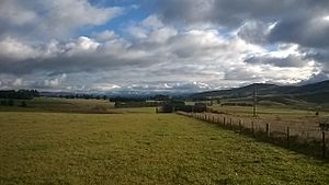
Eyre Creek is a small area in the Southland region of New Zealand. It's located north-east of the Five Rivers Plain. You can find it along State Highway 6, about 18 kilometers (11 miles) north of Lumsden. To its north is the Jollies Hill Pass, often called "the Jollies," which goes around the side of the Mid Dome mountain.
Contents
The Jolly Waggoners Hotel
The very first building in the Eyre Creek area was an accommodation house built in early 1863. It was called the Dome Pass Accommodation House, but everyone knew it as the Jolly Waggoners.
- Who built it? P. K. Bracken, Thomas Crawley, and John Groves.
- Where was it? Just north of where roads from Riverton, Invercargill, and Dunedin met.
- Why was it popular? It was a favorite stop for people traveling with wagons. They could have a fun and "jolly" time there.
Thomas Crawley sold his share in 1867. By 1871, the hotel was not doing well.
A Small Graveyard
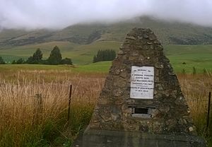
Across the road from where the Jolly Waggoners hotel once stood, there is a small graveyard. Four people who died around the time the hotel was open are buried there. We know about two of them:
- Margaret Smith died in 1865 after her coach overturned in a creek.
- James Cameron died in 1871 from plant poisoning.
A cairn (a pile of stones) stands beside State Highway 6. It remembers these early pioneers who lived and died in the area.
Eyre Creek Station: A Big Farm
In 1859, a large farm called Eyre Creek Station was established. At first, it was part of the nearby Five Rivers Station.
- New Owners: In 1868, a company called Dalgety, Rattray and Company took over. They built a manager's house at what is now Eyre Creek.
- The Stream: Interestingly, the actual stream that gave the station its name was on the northern side of the property. It didn't flow through the main Eyre Creek area.
Changes Over Time
In 1873, William Larnach bought the huge 45,100-acre station for £25,000. He later sold part of it to Henry Driver. In 1879, they sold the station to the New Zealand Agricultural Company. Both Larnach and Driver were directors of this company.
- Financial Troubles: The company didn't do well financially.
- Selling Off Land: Over time, they slowly sold off parts of the large property.
- New Owner: Many managers lived at Eyre Creek until the main homestead (farmhouse) block was sold to John Gibson in 1902.
Today, the Eyre Creek Station is much smaller than the original. Its homestead is now closer to Athol.
The Railway Line
A railway line called the Kingston Branch opened through Eyre Creek on January 28, 1878. Soon after, a special track called a siding was built at Eyre Creek.
- Highest Point: The Eyre Creek station was the highest point on this railway line, at 1093 feet (about 333 meters) above sea level.
Stuck in the Snow
In July 1939, a train traveling from Lumsden to Kingston got stuck in a huge snowdrift at Eyre Creek. The snow was eight feet (about 2.4 meters) deep!
- Even though the train was eventually freed, it had to stay overnight in the snow.
- It took two more days for the train to finally reach its destination.
The Kingston Branch railway line closed on November 26, 1979.
Cycle Trail Today
Today, parts of the old railway track through Eyre Creek are used by the Around the Mountains Cycle Trail. A copy of the old station sign has been put up where the station used to be.


