
Falkland Sound facts for kids

The Falkland Sound (which is called Estrecho de San Carlos in Spanish) is a narrow stretch of sea in the Falkland Islands. It runs from the southwest to the northeast. This important strait separates the two main islands: West Falkland and East Falkland.
Contents
How the Falkland Sound Got Its Name
The Falkland Sound was named in 1690 by a sailor named John Strong. He named it after Viscount Falkland. Later, the name "Falkland" was used for the entire group of islands and their two biggest landmasses.
The Spanish name, "Estrecho de San Carlos," comes from a ship called the San Carlos. This ship visited the area in 1768. It can be a bit confusing because the English name "San Carlos Water" is a much smaller bay on East Falkland. This smaller bay gives its name to places like San Carlos, Port San Carlos, and the San Carlos River.
Captain John Strong, sailing on his ship the Welfare, was the first person to officially land on either West or East Falkland. This happened on January 29, 1690, at a place called Bold Cove. Bold Cove is located near Port Howard, right off the Falkland Sound.
Islands and Towns Along the Sound
Many smaller islands are found within the Falkland Sound. These include Narrows Island, Great Island, the Tyssen Islands, and the Swan Islands. At the northern end of the Sound, you'll find Eddystone Rock. The Arch Islands are located at the southern end.
Several towns and settlements are built along the shores of the Falkland Sound. On East Falkland, you'll find Ajax Bay, New Haven, Port San Carlos, and San Carlos. On West Falkland, there are Port Howard and Fox Bay.
A special car ferry helps people travel between Port Howard on West Falkland and New Haven on East Falkland. This ferry makes it easier to move around the islands.
Some of the bays and inlets that connect to the Sound include:
- Fox Bay (on West Falkland)
- Port Howard (on West Falkland)
- Grantham Sound (on East Falkland)
- San Carlos Water (on East Falkland)
- Ruggles Bay (on East Falkland)
How the Falkland Sound Was Formed


About 400 million years ago, the land that would become the Falkland Islands was part of a huge supercontinent called Gondwana. This land, along with what is now Antarctica's Ellsworth Mountains, broke away from what is now Africa. It then slowly drifted westward.
Later, around 170 million years ago, during the Jurassic period, something amazing happened. The piece of land that would become East Falkland and the piece that would become West Falkland rotated about 120 degrees compared to each other.
Because of this rotation, the natural folds in the rocks of West Falkland now run almost parallel to the Sound, from southwest to northeast. However, the folds in the northern part of East Falkland run east-west. These folds form the eastern entrance to the Sound and border the northern side of San Carlos Water.
The line where these two land pieces meet is called the Falkland Sound Fault. This fault line is very close to and runs parallel with the western shore of the Sound. The southern part of East Falkland, known as Lafonia, is much newer and doesn't have these folds.
Scientists believe that during the Pleistocene era (which was a long time ago), the seabed of the Falkland Sound was about 46 meters (150 feet) lower than it is today. This was low enough for the Sound to have been completely bridged by land at times!
Images for kids
-
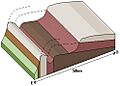
Folding of West Falkland - the Sound is parallel to the folds and would occupy the front left-hand corner of the diagram.
-
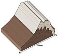
Folding of East Falkland Island - the Sound is at right angles to the folds and would occupy the front right-hand corner of the diagram.
See also
 In Spanish: Estrecho de San Carlos para niños
