Farmingdale (CDP), Maine facts for kids
Quick facts for kids
Farmingdale, Maine
|
|
|---|---|

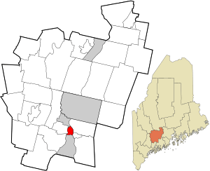
Location in Kennebec County and the state of Maine
|
|
| Country | United States |
| State | Maine |
| County | Kennebec |
| Town | Farmingdale |
| Area | |
| • Total | 2.58 sq mi (6.69 km2) |
| • Land | 2.38 sq mi (6.16 km2) |
| • Water | 0.20 sq mi (0.53 km2) |
| Elevation | 52 ft (16 m) |
| Population
(2020)
|
|
| • Total | 2,000 |
| • Density | 841.40/sq mi (324.87/km2) |
| Time zone | UTC-5 (Eastern (EST)) |
| • Summer (DST) | UTC-4 (EDT) |
| ZIP code |
04344
|
| Area code(s) | 207 |
| FIPS code | 23-24635 |
| GNIS feature ID | 0566053 |
Farmingdale is a small community in the state of Maine, United States. It's known as a census-designated place (CDP). This means it's an area identified by the U.S. Census Bureau for statistical purposes.
Farmingdale is located within the larger town of Farmingdale in Kennebec County. In 2020, about 2,000 people lived in the CDP part of Farmingdale.
Contents
Where is Farmingdale?
Farmingdale is located in the southern part of Kennebec County. It sits right on the Kennebec River.
Nearby Towns and Cities
Farmingdale is surrounded by other communities:
- To the north is the city of Hallowell.
- To the south is the city of Gardiner.
- Across the Kennebec River to the east are the towns of Chelsea and Randolph.
Roads and Travel
Two main roads, U.S. Route 201 and Maine State Route 27, pass through Farmingdale. They are known as Maine Avenue here.
- If you head north, these roads will take you to Hallowell and then about 5 miles (8 km) further to Augusta, which is the capital city of Maine.
- If you go southwest on US 201, you'll pass through Gardiner and reach Brunswick about 26 miles (42 km) away.
- State Route 27 crosses the Kennebec River into Randolph and continues southeast for about 18 miles (29 km) to Wiscasset.
Land and Water
The Farmingdale CDP covers a total area of about 2.6 square miles (6.7 square kilometers).
- Most of this area, about 2.4 square miles (6.2 square kilometers), is land.
- The rest, about 0.2 square miles (0.5 square kilometers), is water, making up almost 8% of its total area.
Who Lives in Farmingdale?
The population of Farmingdale has been counted in different censuses.
| Historical population | |||
|---|---|---|---|
| Census | Pop. | %± | |
| 2020 | 2,000 | — | |
| U.S. Decennial Census | |||
Population Details
In the year 2000, there were 1,935 people living in the Farmingdale CDP. These people lived in 864 households, with 529 of those being families.
Most of the people living in Farmingdale in 2000 were White (97%). A small percentage were Black or African American (0.93%), Native American (0.41%), or Asian (0.67%). Some people identified with two or more races (0.88%). About 0.57% of the population was of Hispanic or Latino background.
Households and Families
- Almost 30% of the households in 2000 had children under 18 living with them.
- About 44% were married couples living together.
- About 14% were households led by a female without a husband present.
- About 34% of all households were made up of people living alone.
- Around 11% of households had someone aged 65 or older living by themselves.
- The average household had 2.20 people, and the average family had 2.78 people.
Age Groups
The population in 2000 was spread out across different age groups:
- 23.7% were under 18 years old.
- 8.0% were between 18 and 24 years old.
- 26.6% were between 25 and 44 years old.
- 25.2% were between 45 and 64 years old.
- 16.6% were 65 years old or older.
The median age in Farmingdale was 39 years. This means half the people were younger than 39, and half were older.
See also
 In Spanish: Farmingdale (condado de Kennebec) para niños
 | Aurelia Browder |
 | Nannie Helen Burroughs |
 | Michelle Alexander |

