
Faulagh facts for kids
Quick facts for kids
Faulagh
Fálach
|
|
|---|---|
|
Townland
|
|

Faulagh
Location in Ireland
|
|
| Country | Ireland |
| Province | Connacht |
| County | County Mayo |
| Elevation | 00 m (0 ft) |
| Irish Grid Reference | F820374 |
Faulagh (which in Irish is Fálach) is a special type of area in Ireland called a townland. It's found in County Mayo, which is in the west of Ireland. Faulagh is a very quiet and remote place. It covers about 946 acres (or 3.8 square kilometers).
You can find Faulagh along the main road that connects Ballycastle to Belmullet. Faulagh and its neighbor, Muingerroon South, are on a mountain. This mountain is next to Bellanaboy, where a large gas processing plant was built.
The name "Faulagh" means "Enclosures." There's a small group of houses and farms in Faulagh. They are located along a small road that leads to the village of Knocknalower. This village is above Pollathomas, which is the main village in the area. Muingerroon South is a larger townland, about 1,454 acres (5.9 square kilometers). Not many people live there. The houses are mostly in a line along the main road, looking out over Carrowmore Lake.
Ancient Discoveries in Faulagh
Faulagh and Muingerroon are home to many very old sites from prehistoric times. These sites are found on the mountain slopes, which are covered in blanket bog. A blanket bog is a type of wet, peaty land.
Megalithic Tombs
On the slopes of Faulagh and Muingerroon, overlooking Carrowmore Lake, you can find several megalithic tombs. Carrowmore Lake is important because it provides drinking water for the whole Erris area. Many of these ancient tombs are hidden under the bog, but some can still be seen.
Long ago, during the Neolithic (New Stone Age) and possibly the Bronze Age, many people likely lived on the southern parts of this mountain. Not much archaeological research has been done here. However, there are old field (agriculture) walls, just like the famous Céide Fields further east.
The southern slopes have different kinds of megalithic tombs. These include court tombs, wedge tombs, and portal tombs. Other structures in the townland are listed as unclassified or as old hut sites. On the northern slopes, facing Sruwaddacon Bay, there's an unclassified tomb known as The Grey Stone. You can see a picture of it in the gallery below.
One of the court tombs on the southern slopes has special carvings. It looks like there are three sets of concentric circles carved into one of its stones. This amazing detail isn't officially recorded in the National Monument (Ireland) register of archaeological sites.
Ancient Pathways
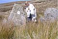
There are also signs of an ancient "pathway" made of vertical schist stone "kerb slabs." These stones show a path that crossed several mountains in the western part of Kilcommon townland. This old path might have gone all the way to Glengad townland, which is about nine kilometers north of Faulagh.
These vertical stones are set into the ground and are now almost covered by the blanket bog. They are very clear at a site in Graghil townland, on the Dún Chiortáin peninsula of Kilcommon. One of these marker stones in Faulagh was almost completely hidden under the bog.
You can find parts of this ancient trail for at least nine kilometers, leading to Graghil townland on the Broadhaven Bay coast. Remnants of this path are found from the townlands of Glengad, through Graghil and Gortbrack, then through Knocknalower, and across to Faulagh and Muingerroon. This trail runs along the middle of the mountainsides. Along this path, many suspected megalithic tombs and prehistoric stone circles have also been found. For example, at Cnoc Nansai, there are many large, flat "cap stones" on the ground. If you reach underneath with a torch, you can see orthostats (upright stones) and a hollow space beneath these large flagstones.
Images for kids
-
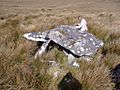
The Grey Stone on the northern slopes of Faulagh Mountain
-
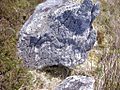
Three groups of concentric circles are carved onto this rock, part of a court tomb on the southern slopes of Faulagh Mountain
-
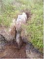
Half buried standing stone, part of way-marked way across mountains, Faulagh, Kilcommon, Erris.
-
Ancient way marked path as it appears in Graghil, Kilcommon, Erris.
-
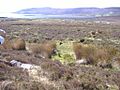
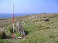
View from the southern slopes of Faulagh towards Carrowmore Lake and pair of standing stones in mid ground
-
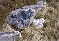
A slightly different view of the rock art
-
Another tomb on the Faulagh slopes


.JPG)


