Ferron, Utah facts for kids
Quick facts for kids
Ferron, Utah
|
|
|---|---|

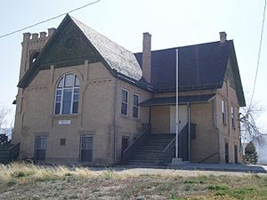
Originally a Presbyterian school, this Ferron landmark has been home to American Legion Post 42 since 1942, April 2008
|
|

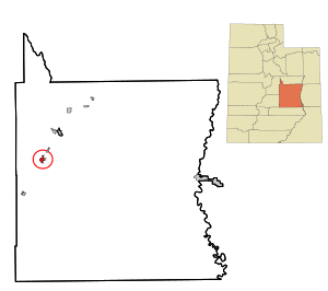
Location within Emery County and the State of Utah
|
|

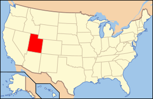
Location of Utah in the United States
|
|
| Country | United States |
| State | Utah |
| County | Emery |
| Named for | Augustus D. Ferron |
| Area | |
| • Total | 2.33 sq mi (6.03 km2) |
| • Land | 2.33 sq mi (6.03 km2) |
| • Water | 0.00 sq mi (0.00 km2) |
| Elevation | 5,971 ft (1,820 m) |
| Population
(2020)
|
|
| • Total | 1,461 |
| • Density | 627.04/sq mi (242.29/km2) |
| Time zone | UTC-7 (Mountain (MST)) |
| • Summer (DST) | UTC-6 (MDT) |
| ZIP code |
84523
|
| Area code(s) | 435 |
| FIPS code | 49-25180 |
| GNIS feature ID | 1441026 |
Ferron is a small city located in Emery County, Utah, in the United States. It's known for its friendly community and beautiful surroundings. In 2020, about 1,461 people lived here.
History of Ferron
Ferron was first settled in 1877 by Mormon families. Three families bravely answered a call from their church to start a new community in the area known as Castle Valley. They began their journey on November 15, 1877, and arrived about three weeks later.
When they first arrived, the settlers lived in "dugouts," which were simple homes dug into the ground. Later, they became farmers, growing food to support themselves.
The town got its name from a government surveyor named Augustus D. Ferron. He surveyed the area in the late 1860s or early 1870s. The story goes that he agreed to be "dunked" in a nearby creek. In return, the creek was named "Ferron's Creek." When the town was later established, the "s" was dropped, and both the creek and the town became known as "Ferron."
Geography of Ferron
Ferron is located in the western part of Emery County. It sits along Utah State Route 10. This road connects Ferron to other towns. For example, it's about 11 miles (18 km) northeast to Castle Dale, which is the main town of the county. It's also about 14 miles (23 km) southwest to Emery.
According to the United States Census Bureau, Ferron covers a total area of about 2.3 square miles (6.0 square kilometers). All of this area is land, meaning there are no large bodies of water like lakes or rivers within the city limits.
Ferron's Population
| Historical population | |||
|---|---|---|---|
| Census | Pop. | %± | |
| 1890 | 299 | — | |
| 1900 | 660 | 120.7% | |
| 1910 | 1,022 | 54.8% | |
| 1920 | 463 | −54.7% | |
| 1930 | 508 | 9.7% | |
| 1940 | 515 | 1.4% | |
| 1950 | 478 | −7.2% | |
| 1960 | 386 | −19.2% | |
| 1970 | 663 | 71.8% | |
| 1980 | 1,718 | 159.1% | |
| 1990 | 1,606 | −6.5% | |
| 2000 | 1,623 | 1.1% | |
| 2010 | 1,626 | 0.2% | |
| 2020 | 1,461 | −10.1% | |
| Source: U.S. Census Bureau | |||
In 2000, there were 1,623 people living in Ferron. Most of the people living in Ferron were White. A small percentage of the population was Hispanic or Latino.
Many households in Ferron had children under 18 living with them. The average household had about three people. The average age of people in Ferron was 33 years old.
Climate in Ferron
| Climate data for Ferron, UT | |||||||||||||
|---|---|---|---|---|---|---|---|---|---|---|---|---|---|
| Month | Jan | Feb | Mar | Apr | May | Jun | Jul | Aug | Sep | Oct | Nov | Dec | Year |
| Record high °F (°C) | 63 (17) |
68 (20) |
81 (27) |
86 (30) |
96 (36) |
100 (38) |
102 (39) |
104 (40) |
97 (36) |
88 (31) |
77 (25) |
64 (18) |
104 (40) |
| Mean daily maximum °F (°C) | 36.1 (2.3) |
41.7 (5.4) |
51.5 (10.8) |
61.2 (16.2) |
70.9 (21.6) |
81.4 (27.4) |
88.0 (31.1) |
85.5 (29.7) |
77.7 (25.4) |
65.6 (18.7) |
50.1 (10.1) |
38.2 (3.4) |
62.3 (16.8) |
| Mean daily minimum °F (°C) | 11.5 (−11.4) |
17.6 (−8.0) |
25.9 (−3.4) |
33.6 (0.9) |
42.8 (6.0) |
51.6 (10.9) |
58.5 (14.7) |
56.0 (13.3) |
47.2 (8.4) |
35.6 (2.0) |
23.4 (−4.8) |
13.8 (−10.1) |
34.8 (1.5) |
| Record low °F (°C) | −17 (−27) |
−15 (−26) |
1 (−17) |
13 (−11) |
22 (−6) |
27 (−3) |
39 (4) |
35 (2) |
22 (−6) |
8 (−13) |
−4 (−20) |
−21 (−29) |
−21 (−29) |
| Average precipitation inches (mm) | 0.66 (17) |
0.60 (15) |
0.57 (14) |
0.51 (13) |
0.69 (18) |
0.50 (13) |
0.87 (22) |
1.01 (26) |
0.95 (24) |
0.92 (23) |
0.52 (13) |
0.54 (14) |
8.34 (212) |
| Average snowfall inches (cm) | 8.2 (21) |
6.4 (16) |
3.2 (8.1) |
1.0 (2.5) |
0.1 (0.25) |
0 (0) |
0 (0) |
0.1 (0.25) |
0.1 (0.25) |
0.6 (1.5) |
2.1 (5.3) |
5.6 (14) |
27.4 (69.15) |
| Source: http://www.wrcc.dri.edu/cgi-bin/cliMAIN.pl?ut2798 | |||||||||||||
04/20/1897 to 06/10/2016
See also
 In Spanish: Ferron (Utah) para niños
 | George Robert Carruthers |
 | Patricia Bath |
 | Jan Ernst Matzeliger |
 | Alexander Miles |


