Floe Peak facts for kids
Quick facts for kids Floe Peak |
|
|---|---|

Floe Peak
|
|
| Highest point | |
| Elevation | 3,006 m (9,862 ft) |
| Prominence | 436 m (1,430 ft) Canadian Rockies |
| Parent peak | Mount Verendrye (3083 m) |
| Geography | |
| Topo map | NTS 82N01 |
| Geology | |
| Age of rock | Cambrian |
| Type of rock | Ottertail Limestone |
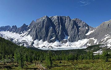
Floe Peak is a tall mountain in the Canadian Rockies of British Columbia, Canada. It stands 3,006 meters (about 9,862 feet) high. You can find it on the western edge of Kootenay National Park.
Interestingly, this mountain's name hasn't been officially decided yet. Its closest taller neighbor is Foster Peak, about 3 kilometers (1.9 miles) to the northwest. Both peaks are part of the Vermilion Range. Floe Peak is part of a famous mountain feature called 'The Rockwall' within the Vermilion Range. It gets its name from Floe Lake, which sits below the huge northern cliffs of the peak. Floe Lake is a very beautiful spot in Kootenay Park and you can reach it by following the Floe Lake Trail.
How Floe Peak Was Formed
Floe Peak is made mostly of a type of rock called limestone. This rock formed from tiny bits of shells and other materials that settled at the bottom of ancient seas. Over millions of years, these layers of sediment hardened into rock.
This process happened during the Precambrian and Jurassic periods, which were a very long time ago. Later, during an event called the Laramide orogeny, huge forces pushed these rock layers upwards. This movement created the mountains we see today, including Floe Peak.
Weather and Climate
Floe Peak is located in a subarctic climate zone. This means it has very cold winters with lots of snow. The summers are usually mild, not too hot.
Temperatures can drop below -20 degrees Celsius (-4 degrees Fahrenheit). With the wind chill, it can feel even colder, sometimes below -30 degrees Celsius (-22 degrees Fahrenheit). Water from melting snow and rain flows off the mountain. This water goes east into Floe Creek, which then joins the Vermilion River. Some water also flows west into streams that lead to the Kootenay River.
 | Percy Lavon Julian |
 | Katherine Johnson |
 | George Washington Carver |
 | Annie Easley |


