
Fort Necessity National Battlefield facts for kids
Quick facts for kids Fort Necessity National Battlefield |
|
|---|---|
|
IUCN Category III (Natural Monument)
|
|

The reconstructed Fort Necessity
|
|

Fort Necessity National Battlefield
Location in Pennsylvania

Fort Necessity National Battlefield
Location in the United States
|
|
| Location | Wharton Township, Fayette, Pennsylvania, United States |
| Area | 902.8 acres (365.4 ha) |
| Elevation | 1,955 ft (596 m) |
| Established | March 4, 1931 |
| Website | Fort Necessity National Battlefield |
|
Fort Necessity National Battlefield
|
|
| Nearest city | Uniontown |
| NRHP reference No. | 66000664 |
| Added to NRHP | October 15, 1966 |
Fort Necessity National Battlefield is a special place in Fayette County, Pennsylvania. It protects the exact spot where an important battle happened long ago. This battle, called the Battle of Fort Necessity, took place on July 3, 1754.
It was one of the first fights in the French and Indian War. During this battle, British colonial soldiers, led by a young Colonel George Washington, had to surrender. They gave up to French and Native American forces.
The park also includes other interesting historical sites. You can find the Mount Washington Tavern there. This tavern was once a popular inn along the National Road, America's first major highway. There's also a separate area with the grave of British General Edward Braddock, who died in 1755.
Contents
The Battle of Fort Necessity (1754)


After a smaller fight, George Washington and his troops returned to a place called Great Meadows. This area is now in Fayette County, Pennsylvania. Washington decided they needed to build a fort to protect their supplies. He supposedly named it Fort Necessity, meaning it was a necessary fort.
The fort was a simple wooden fence, called a palisade. It was built to guard things like gunpowder and food. Washington even worried his own soldiers might try to take supplies.
By June 13, 1754, Washington had about 295 colonial soldiers. He also had around 100 British army troops from South Carolina. Washington spent time making a wilderness road longer. This road went west towards the Monongahela River. He wanted to reach a river crossing point about 41 miles (66 km) away.
This crossing was near a place called Redstone Creek. There was an ancient Native American earthwork mound there. Later, in 1759, a new fort called Fort Burd was built at this spot. Today, this area is known as Brownsville, Pennsylvania. It was an important stop for travelers crossing the mountains.
Washington chose to follow an old Native American path called Nemacolin's Trail. This path was a bit easier than other routes. It led to the Monongahela River, which was good for travel by boat. The Redstone area was a perfect spot for a base. It had one of the few easy places to cross the wide river.
On July 3, Washington's troops were surrounded by French and Native American forces. They fought for hours in heavy rain. Washington realized his situation was very difficult. He agreed to surrender terms that night. The terms allowed his soldiers to leave peacefully the next day.
The French then took over the fort and burned it down. Washington later said he didn't understand the French surrender document completely. He didn't know it said he was responsible for the death of a French officer. If he had known, he would not have signed it.
Fort Necessity National Battlefield Today
During the 1930s, people worked to save the Fort Necessity site. On March 4, 1931, the United States Congress made it a National Battlefield Site. It was first managed by the War Department. Later, in 1933, it became part of the National Park Service. On August 10, 1961, it was officially named a National Battlefield.
The battlefield was added to the National Register of Historic Places on October 15, 1966. This means it's a very important historical site. Scientists have studied the area to find out where the original fort stood. In the 1970s, a copy of the fort was built on the site.
A new visitor center opened on October 8, 2005. It also has a special area about the National Road. The battlefield is always being cared for. Visitors are asked to stay out of certain areas. This is because the remains of the soldiers who died there were never found. The battlefield is treated as sacred ground.
Mount Washington Tavern
On a hill next to the battlefield, you'll find the Mount Washington Tavern. This building is a great example of the inns that used to be along the National Road. The National Road was the first highway in the United States built with government money.
The land where the tavern stands was once owned by George Washington himself. He bought the site in 1770, years after he fought his first battle there. The tavern was built around the 1830s by Judge Nathanial Ewing. It became a popular stop for travelers.
The Sampey family ran the tavern starting in 1840. They kept it going until railroads became popular. When people started traveling by train, the National Road was used less. This made the inn lose money.
In 1855, the Fazenbaker family bought the tavern. They lived there as a private home for 75 years. In 1932, the state of Pennsylvania bought the property. Then, in 1961, the National Park Service bought it. This made the tavern part of Fort Necessity National Battlefield.
The Mount Washington Tavern shows what early American inns were like. It had a simple barroom where people gathered. There was also a nicer parlor for relaxing. Bedrooms were often crowded, with many people sleeping in one room.
-
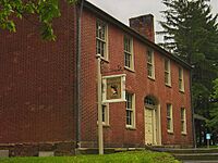
The Mount Washington Tavern was a stop for stagecoaches on the National Road.
-
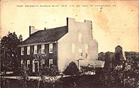
An old postcard showing the Mount Washington Tavern.


General Braddock's Grave Site


About one mile (1.6 km) northwest of the battlefield is another part of the park. Here you'll find the grave of General Edward Braddock. He was a British commander who led a large expedition in 1755. His troops built Braddock's Road, a path through western Pennsylvania.
Braddock was badly hurt in the Battle of the Monongahela. This happened as his forces were moving towards Fort Duquesne. He and his soldiers retreated along the wilderness road. Braddock died on July 13, 1755. George Washington helped with his burial ceremony.
Braddock was buried under the road itself. This was done to hide his grave from the French and Native American enemies. In 1804, his remains were found by workers fixing the road. A special marker was put up in 1913 to honor him.
See also
- Jumonville (Pennsylvania), a camp and retreat center in Fayette County
