Fourmile Canyon facts for kids
Fourmile Canyon is a mountain canyon in western Boulder County, Colorado. A stream called Fourmile Creek flows through it. This creek starts on the side of Niwot Mountain and flows east and south. It passes through small communities like Sunset, Wallstreet, Salina, and Crisman. Finally, it joins Boulder Creek in Boulder Canyon. This spot is about four miles west of where the old Boulder Railroad Depot used to be.
In September 2010, a big wildfire happened in Fourmile Canyon and the areas around it. This fire is often called the Fourmile Canyon Fire.
Early History of the Canyon
In 1859, people found gold in the Fourmile Canyon area. This led to the first settlements there. Later, in 1872, a mineral called tellurium was discovered. This discovery brought new energy to the local mining towns.
Fourmile Canyon was also home to the first narrow-gauge railroad in the area. This special train track connected the Union Pacific Railroad to the mines and mountain towns near Ward. It was also the starting point for the "Switzerland Trail," a popular tourist route that wound through the mountains. The Fourmile narrow-gauge track was used from the 1880s until 1919.
The 2010 Wildfire
Quick facts for kids Fourmile Canyon fire |
|
|---|---|

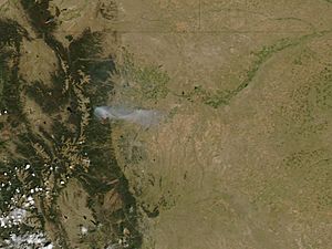
The Fourmile Canyon Fire continued to burn on September 7, 2010, visible from NASA's Aqua satellite.
|
|
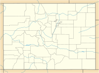
| Coordinates | 40°02′53″N 105°23′24″W / 40.048°N 105.39°W |
| Statistics | |
| Date(s) | September 6, 2010 — September 16, 2010 |
| Map | |

How the Fire Started and Spread
Day One: Monday, September 6, 2010
Around 10:00 a.m., a fire pit that wasn't put out properly started burning again. A volunteer firefighter had used it a few days earlier to burn brush. Within minutes, a wildfire began to spread quickly through the canyon forest.
Strong winds, blowing at 15 to 41 miles per hour, helped the fire grow fast. The air was also very dry, with only 7 percent humidity. Flames reached 20 to 50 feet high.
Many fire departments and forest services quickly came to help. People living in the area had to leave their homes, and all roads into the fire zone were closed. Airplanes began dropping fire retardant to help stop the flames. By the end of this day, the fire had burned about 5,733 acres. This was 93 percent of the total area that would eventually burn.
Day Two: Tuesday, September 7, 2010
The fire grew by only 375 acres on the second day, reaching a total of 6,108 acres. Colorado's governor, Bill Ritter, declared a state of emergency. This meant he set aside $5 million to help fight the fire.
About 3,500 people had been evacuated from their homes. More than 200 firefighters from over 35 different groups were working to control the blaze. By the end of the second night, over 92 homes were reported destroyed. Sadly, nine of these homes belonged to firefighters who were helping to fight the fire.
Day Three: Wednesday, September 8, 2010
The weather helped firefighters on day three. The air was more humid, and temperatures were cooler. This allowed them to create and strengthen lines to control the fire. The size of the fire stayed at 6,108 acres.
Earlier, 20 people were reported missing from the area. By nightfall, this number dropped to 5. The number of homes destroyed increased to 150. At the time, this made it the second-worst wildfire in Colorado's history.
Day Four: Thursday, September 9, 2010
The number of firefighters grew to 430. All people who were reported missing had been found and were safe. Some residents were allowed to return home in the morning. However, they had to leave again in the afternoon because of strong winds. Boulder County estimated that 169 homes had burned.
By 3 p.m., winds were blowing at 40 miles per hour, with gusts up to 64 mph. The air also became very dry again. These conditions caused parts of the fire that hadn't burned before to ignite. By the end of the day, the fire was measured at 6,131 acres.
Day Five: Friday, September 10, 2010
Firefighters continued their hard work. Even with low humidity and strong wind gusts, the fire did not grow much. The final size of the fire was recorded at 6,181 acres.
Days Six through Eleven: September 11-17, 2010
After September 10, the fire did not get any bigger, even though the air stayed dry and winds were strong. On September 13, the fire was declared 100% contained. This meant firefighters had built lines around the entire fire to stop it from spreading. Crews then focused on finding and putting out any remaining hot spots until September 17.
The Boulder County Sheriff's Office allowed all residents to return to their homes. Utility companies and public works teams worked to fix damaged power lines and roads. People were reminded to be careful in the fire area because of all the fire and utility vehicles.
In total, the Fourmile Fire burned 6,181 acres, which is about 10 square miles. This final number was more accurate due to better GPS mapping after the fire.
Aftermath and Long-Term Impact
Out of 474 homes that were inside or very close to the fire area, 168 homes (35%) were destroyed. At the time, this was the most homes destroyed by any wildfire in Colorado's history. However, this number was later passed by the High Park fire and the Waldo Canyon fire in June 2012.
The cost of the fire was very high. Insurance claims for the damage added up to an estimated $217 million. This made it the most expensive wildfire in Colorado's history, based on insurance claims, up to 2010. The total cost to manage the fire, including fighting it and repairing the area afterward, was about $14.1 million.
 | Tommie Smith |
 | Simone Manuel |
 | Shani Davis |
 | Simone Biles |
 | Alice Coachman |


