
Francis Scott Key Bridge (Baltimore) facts for kids
Quick facts for kids Francis Scott Key Bridge |
|
|---|---|
.jpg)
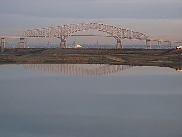
View from Fort Armistead Park in 2015
|
|
| Coordinates | 39°13′1″N 76°31′42″W / 39.21694°N 76.52833°W |
| Carries | 4 lanes of |
| Crosses | Patapsco River |
| Locale | Baltimore metropolitan area, Maryland, U.S. |
| Maintained by | Maryland Transportation Authority |
| ID number | 300000BCZ472010 |
| Characteristics | |
| Design | Steel arch-shaped continuous through truss bridge |
| Material | Steel |
| Total length | 8,636 feet (2,632.3 m; 1.6 mi) |
| Longest span | 1,200 feet (366 m) |
| Clearance below | 185 feet (56 m) |
| History | |
| Designer | J. E. Greiner Company |
| Construction begin | 1972 |
| Opened | March 23, 1977 |
| Collapsed | March 26, 2024 |
| Statistics | |
| Toll | $4.00 |

_along_northbound_Maryland_State_Route_173_(Fort_Smallwood_Road)_just_north_of_Cabot_Drive_in_Pasadena,_Anne_Arundel_County,_Maryland.jpg)
The Francis Scott Key Bridge, also known as the Key Bridge, was a large bridge in Maryland, United States. It crossed the Patapsco River near Baltimore. The bridge opened on March 23, 1977. It carried four lanes of traffic for Interstate 695, which is part of the Baltimore Beltway.
The Key Bridge connected Dundalk in Baltimore County with Hawkins Point in Baltimore. Sadly, on March 26, 2024, the main parts of the bridge collapsed. This happened after a large container ship called the MV Dali hit one of its main support piers.
The bridge was first called the Outer Harbor Crossing. In 1976, it was renamed after Francis Scott Key (1779–1843). He wrote the words to "The Star-Spangled Banner", which is the US national anthem. The Key Bridge was the second-longest bridge in the Baltimore metropolitan area. It was about 8,636 feet (2,632 m) long. Its main span, which is the longest part between two supports, was 1,200 feet (366 m). This made it one of the longest continuous truss bridges in the world.
The Maryland Transportation Authority (MDTA) operated the bridge. It was one of three toll crossings for Baltimore's harbor. The other two are the Baltimore Harbor and Fort McHenry tunnels. About 11.5 million vehicles used the bridge each year. Many trucks carrying hazardous materials used the bridge because they were not allowed in the tunnels. The bridge helped complete the I-695 highway system.
Contents
History of the Key Bridge
Building the Bridge
By the early 1960s, the first harbor crossing, the Baltimore Harbor Tunnel, was getting too busy. So, officials decided they needed a second way to cross Baltimore's harbor. They first planned another tunnel under the Patapsco River.
In 1968, money was set aside for this "Outer Harbor Tunnel" project. However, when construction bids came in, they were much higher than expected. So, new plans were made, including building a four-lane bridge instead. A bridge had a big advantage: it could carry trucks with dangerous materials that were not allowed in tunnels.
In April 1971, the state of Maryland approved the bridge project. Construction of the Outer Harbor Bridge began in 1972. The J. E. Greiner Company designed the bridge. Each of the bridge's main supports, called piers, had special protection. These protections were strong structures designed to keep ships from hitting the piers directly.
In 1976, while the bridge was still being built, it was named after Francis Scott Key. He wrote the poem that became "The Star-Spangled Banner." Key was inspired to write the poem after seeing the Battle of Baltimore in 1814. He was on a ship in Baltimore Harbor, very close to where the bridge was later built. A buoy (a floating marker) in the water now marks this spot.
How the Bridge Operated
The Key Bridge opened to traffic on March 23, 1977. The entire bridge project, including the roads leading to it, was about 8.7 miles (14.00 km) long. In 1978, the bridge won an award for its design. In 1980, a cargo ship hit the Key Bridge, but the bridge was not badly damaged.
The bridge had four lanes for traffic. Over time, the roads leading to the bridge were also widened to handle more cars.
By 2013, the toll for cars was $4. The bridge used the E-ZPass system, which allowed drivers to pay tolls electronically. In 2019, the bridge became fully cashless. This meant drivers paid using E-ZPass or by video tolling, where a picture of their license plate was taken.
-
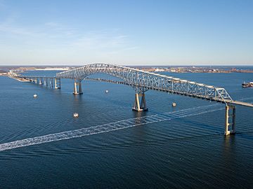
Key Bridge with Baltimore in the background, viewed from Cox Creek Industrial Park, in northeast Anne Arundel County, November 2011 to the south
-
Key Bridge looking to the northeast with Sparrows Point and the Bethlehem Steel Corporation steel mill and shipyards of southeast Baltimore County in the distance, February 2018


Bridge Collapse

On March 26, 2024, at 1:28 AM, the main parts of the bridge collapsed. This happened after the container ship MV Dali lost power and crashed into a main support pier. Experts noted that the Key Bridge was built before modern safety designs were common. Newer bridges often have extra support structures to prevent such a collapse.
An eight-person maintenance crew was working on the bridge when it collapsed. They are believed to be the only people who were hurt or died. The ship's crew sent a distress call just before the crash. This warning allowed police and bridge workers to stop traffic from going onto the bridge. This quick action likely saved many lives.
The collapse blocked the Patapsco shipping channel. This stopped almost all ship traffic to the Port of Baltimore. Maryland Governor Wes Moore declared a state of emergency. The economic losses were estimated to be about $15 million each day.
Temporary channels were opened by April 20, allowing some ships to pass. A deeper channel was opened later, letting larger ships through. In May, authorities announced they would use explosives to remove most of the remaining bridge parts.
.svg)
Replacing the Bridge
Hours after the collapse, President Joe Biden said that the US government would pay for the entire cost of rebuilding the bridge. On May 2, 2024, officials from Maryland said they plan to replace the bridge by autumn 2028. The estimated cost for the new bridge is between $1.7 billion and $1.9 billion.
See also
 In Spanish: Puente Francis Scott Key para niños
