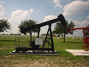
Freer, Texas facts for kids
Quick facts for kids
Freer, Texas
|
|
|---|---|
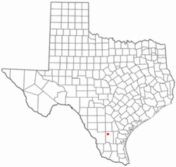
Location of Freer, Texas
|
|
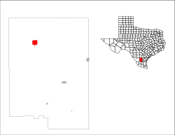 |
|
| Country | United States |
| State | Texas |
| County | Duval |
| Area | |
| • Total | 4.13 sq mi (10.71 km2) |
| • Land | 4.12 sq mi (10.68 km2) |
| • Water | 0.01 sq mi (0.03 km2) |
| Elevation | 518 ft (158 m) |
| Population
(2020)
|
|
| • Total | 2,461 |
| • Density | 595.9/sq mi (229.79/km2) |
| Time zone | UTC-6 (Central (CST)) |
| • Summer (DST) | UTC-5 (CDT) |
| ZIP code |
78357
|
| Area code(s) | 361 |
| FIPS code | 48-27432 |
| GNIS feature ID | 2410544 |
Freer is a city located in Duval County, Texas, in the United States. In 2020, about 2,461 people lived there.
Contents
Where is Freer Located?
Freer is in the northwestern part of Duval County, Texas. You can find it at these coordinates: 27°52′45″N 98°36′58″W / 27.87917°N 98.61611°W.
Several important roads pass through or near Freer. U.S. Route 59 goes through the city as Riley Street. This road can take you northeast about 68 miles (109 km) to Beeville or southwest 59 miles (95 km) to Laredo.
Texas State Highway 16 (Norton Avenue) crosses US 59 in the middle of Freer. It goes north 111 miles (179 km) to San Antonio and southwest 92 miles (148 km) to Zapata, which is on the Rio Grande river.
Texas State Highway 44 also runs through Freer with US 59. It leads east 25 miles (40 km) to San Diego, which is the main town of Duval County. It also goes 35 miles (56 km) to Alice, and west 47 miles (76 km) to Interstate 35 at Encinal.
The United States Census Bureau says that Freer covers a total area of about 4.13 square miles (10.7 km²). Only a very small part of this area, about 0.01 square miles (0.03 km²), is water.
How Many People Live in Freer?
| Historical population | |||
|---|---|---|---|
| Census | Pop. | %± | |
| 1940 | 2,346 | — | |
| 1950 | 2,280 | −2.8% | |
| 1960 | 2,734 | 19.9% | |
| 1970 | 2,804 | 2.6% | |
| 1980 | 3,213 | 14.6% | |
| 1990 | 3,271 | 1.8% | |
| 2000 | 3,241 | −0.9% | |
| 2010 | 2,818 | −13.1% | |
| 2020 | 2,461 | −12.7% | |
| U.S. Decennial Census | |||
In 2020, the 2020 United States census counted 2,461 people living in Freer. There were 809 households and 663 families in the city.
Most people in Freer are of Hispanic or Latino background, making up about 82% of the population. Other groups include White (12.88%), Asian (0.98%), and Mixed/multiracial (3.74%).
Education in Freer
The students in Freer attend schools that are part of the Freer Independent School District.
Famous People from Freer
Many interesting people have come from Freer, including:
- Jim Acker (born 1958) – A former professional baseball pitcher who played for teams like the Toronto Blue Jays.
- Toni Adams (1964–2010) – A professional wrestling manager.
- Steve McMichael (born 1957) – A former American football player for the Chicago Bears and also a professional wrestler.
- Paul Sadler (born 1955) – A lawyer and politician from Texas.
- Buddy Temple (1942–2015) – A businessman and politician.
Media and Climate
Freer has its own radio station, KBRA-FM, which broadcasts at 95.9 MHz.
The climate in Freer is known as a humid subtropical climate. This means it has hot, humid summers and winters that are usually mild to cool.
| Climate data for Freer, Texas (1991–2020 normals, extremes 1962–2008, 2011–present) | |||||||||||||
|---|---|---|---|---|---|---|---|---|---|---|---|---|---|
| Month | Jan | Feb | Mar | Apr | May | Jun | Jul | Aug | Sep | Oct | Nov | Dec | Year |
| Record high °F (°C) | 95 (35) |
101 (38) |
103 (39) |
107 (42) |
111 (44) |
116 (47) |
110 (43) |
111 (44) |
112 (44) |
102 (39) |
97 (36) |
95 (35) |
116 (47) |
| Mean daily maximum °F (°C) | 66.2 (19.0) |
71.2 (21.8) |
77.7 (25.4) |
84.4 (29.1) |
90.7 (32.6) |
94.8 (34.9) |
97.3 (36.3) |
98.4 (36.9) |
92.0 (33.3) |
85.3 (29.6) |
75.1 (23.9) |
67.8 (19.9) |
83.4 (28.6) |
| Daily mean °F (°C) | 54.7 (12.6) |
59.6 (15.3) |
66.1 (18.9) |
72.2 (22.3) |
79.1 (26.2) |
83.6 (28.7) |
85.5 (29.7) |
85.9 (29.9) |
80.5 (26.9) |
73.6 (23.1) |
63.8 (17.7) |
56.5 (13.6) |
71.8 (22.1) |
| Mean daily minimum °F (°C) | 43.3 (6.3) |
48.0 (8.9) |
54.6 (12.6) |
60.0 (15.6) |
67.4 (19.7) |
72.3 (22.4) |
73.7 (23.2) |
73.3 (22.9) |
68.9 (20.5) |
61.9 (16.6) |
52.5 (11.4) |
45.3 (7.4) |
60.1 (15.6) |
| Record low °F (°C) | 12 (−11) |
14 (−10) |
20 (−7) |
35 (2) |
41 (5) |
54 (12) |
60 (16) |
58 (14) |
43 (6) |
36 (2) |
20 (−7) |
16 (−9) |
12 (−11) |
| Average precipitation inches (mm) | 1.25 (32) |
1.31 (33) |
1.92 (49) |
2.08 (53) |
2.80 (71) |
3.07 (78) |
2.44 (62) |
2.45 (62) |
3.35 (85) |
1.82 (46) |
1.42 (36) |
1.24 (31) |
25.15 (639) |
| Average snowfall inches (cm) | 0.0 (0.0) |
0.0 (0.0) |
0.0 (0.0) |
0.0 (0.0) |
0.0 (0.0) |
0.0 (0.0) |
0.0 (0.0) |
0.0 (0.0) |
0.0 (0.0) |
0.0 (0.0) |
0.0 (0.0) |
0.0 (0.0) |
0.0 (0.0) |
| Average precipitation days (≥ 0.01 in) | 3.3 | 4.2 | 4.0 | 3.6 | 3.9 | 4.4 | 2.8 | 3.0 | 5.7 | 3.4 | 2.9 | 3.9 | 45.1 |
| Average snowy days (≥ 0.1 in) | 0.0 | 0.0 | 0.0 | 0.0 | 0.0 | 0.0 | 0.0 | 0.0 | 0.0 | 0.0 | 0.0 | 0.0 | 0.0 |
| Source: NOAA | |||||||||||||
See also
 In Spanish: Freer (Texas) para niños
 | Janet Taylor Pickett |
 | Synthia Saint James |
 | Howardena Pindell |
 | Faith Ringgold |


