
Zapata, Texas facts for kids
Quick facts for kids
Zapata, Texas
|
|
|---|---|

U.S. Highway 83 in Zapata
|
|
 |
|

Zapata, Texas
Location in Texas

Zapata, Texas
Location in the United States
|
|
| Country | |
| State | |
| County | Zapata |
| Area | |
| • Total | 9.6 sq mi (25 km2) |
| • Land | 7.6 sq mi (20 km2) |
| • Water | 2.0 sq mi (5 km2) |
| Elevation | 394 ft (120 m) |
| Population
(2013)
|
|
| • Total | 14,390 |
| • Density | 1,499/sq mi (579/km2) |
| Time zone | UTC-6 (Central (CST)) |
| • Summer (DST) | UTC-5 (CDT) |
| ZIP code |
78076
|
| Area code(s) | 956 |
| FIPS code | 48-80716 |
| GNIS feature ID | 1350720 |
Zapata is a special kind of community in Zapata County, Texas, United States. It's called a census-designated place (CDP). This means it's a place the government counts for population, but it doesn't have its own city government. Zapata is also the county seat, which is like the main town for the county.
In 2010, about 14,018 people lived here. Even without a city government, Zapata County has four elected county commissioners. They are chosen by people in different areas. There's also an elected judge who helps run things for the whole county.
Contents
History of Zapata
Zapata got its name from a brave leader named José Antonio de Zapata. He was a commander in the cavalry, which is a group of soldiers who ride horses. He fought for the Republic of the Rio Grande, and Zapata was once part of that republic. He passed away in 1839.
Where is Zapata?
Zapata is located at 26°54′22″N 99°16′12″W / 26.90611°N 99.27000°W.
The area of Zapata is about 9.6 square miles (25 square kilometers). Most of this area, about 7.6 square miles (20 square kilometers), is land. The rest, about 2.0 square miles (5.2 square kilometers), is water.
Fun Things to Do
Zapata is right next to Falcon International Reservoir. This big lake is a popular spot for fishing. Many fishing events happen here throughout the year.
The community also has several parks where you can play and relax. One of the most well-known parks is Romeo Flores Park.
People of Zapata
| Historical population | ||
|---|---|---|
| Year | Pop. | ±% |
| 1950 | 343 | — |
| 1960 | 2,031 | +492.1% |
| 1970 | 2,102 | +3.5% |
| 1980 | 3,831 | +82.3% |
| 1990 | 4,594 | +19.9% |
| 2000 | 4,856 | +5.7% |
| 2010 | 5,089 | +4.8% |
| 2012 | 5,173 | +1.7% |
| source: | ||
In 2010, there were 5,089 people living in Zapata. Many families live here. About 95% of the people in Zapata are of Hispanic or Latino background.
In 2000, about 31% of the people were under 18 years old. This means there are many kids and teenagers in Zapata! The average age of people living here was 32 years old.
Youth Groups
Zapata has groups for young people to join:
- Law Enforcement Exploring
- Girl Scouts
Hang Gliding Adventures
Zapata is famous around the world for hang gliding! More world records for hang gliding have been set here than anywhere else.
Since 2000, the World Record Encampment has taken place at the Zapata County Airport. This is where hang gliders try to fly the longest distances. In 2002, Mike Barber set a record by flying 438 miles. The current world record is 472 miles, set by Dustin Martin in 2012.
Getting Around
Here are some of the main roads that go through Zapata:
 U.S. Highway 83: This highway goes from Brownsville to Zapata and then all the way to Westhope.
 Texas State Highway 16: This road connects Zapata to Wichita Falls.
 Farm to Market Road 496: This road goes from Zapata to Falcon Mesa.
 Farm to Market Road 3074: This road also connects to Falcon Mesa.
The Zapata County Airport (FAA: APY) is available for smaller planes and general flights.
Nearby Cities
Zapata is close to several other cities, both in Texas and in Mexico. Here are a few:
| City | Population | Distance (km) |
|---|---|---|
| Nuevo Laredo, Tamaulipas | 373,725 | 81 km (50 mi) |
| Laredo, Texas | 236,091 | 81 km (50 mi) |
| Monterrey, Nuevo Leon | 4,080,329 | 227 km (141 mi) |
| Reynosa, Tamaulipas | 589,466 | 163 km (101 mi) |
| Corpus Christi, Texas | 305,215 | 264 km (164 mi) |
| San Antonio, Texas | 1,327,407 | 330 km (205 mi) |
| Heroica Matamoros, Tamaulipas | 449,815 | 256 km (159 mi) |
| Brownsville, Texas | 175,023 | 248 km (154 mi) |
| Dallas, Texas | 1,197,816 | 776 km (482 mi) |
Bass Fishing
Falcon International Reservoir in Zapata is becoming very famous for its bass fishing. Many people, often called "Winter Texans," visit Zapata between November and April. They usually stay in travel campers to enjoy the great fishing.
Economy and Jobs
The main jobs in Zapata County are in education, health and social services, and retail. The natural gas and oil industries are also very important.
Today, Zapata County's economy relies on oil and gas production, ranching, trading, and tourism. The biggest employers are in mining/energy, building, retail, healthcare, and other services. The government also provides many jobs in the county.
Education in Zapata
All of Zapata County is part of the Zapata County Independent School District (ZCISD). This school district is known as Class 4A. Students take part in many academic and sports events through UIL (University Interscholastic League).
Sports offered by the schools include cross country, volleyball, football, basketball, tennis, golf, track & field, softball, and baseball. They also have powerlifting.
The Zapata High School Mariachi Band, called Mariachi Halcon, has won the state championship in their division. A film about them, Mariachi High, was shown on PBS in 2012.
Colleges and Universities
Students from Zapata can go to colleges in nearby cities. Laredo is about 50 miles north. There, they can attend Laredo Community College or Texas A&M International University.
Fifty miles south in Rio Grande City, there are campuses for South Texas College and the University of Texas–Rio Grande Valley.
Public Schools
Zapata County has one school district: the Zapata County Independent School District (ZCISD). All schools listed below are in the city of Zapata.
Zapata County Independent School District Schools
All parts of Zapata that are in the ZCISD go to Zapata High School.
Middle Schools
- Zapata Middle School
Elementary Schools
- Arturo L. Benavides Elementary School
- Fidel and Andrea R. Villarreal Elementary School
- Zapata North Elementary School
- Zapata South Elementary School
Images for kids
-
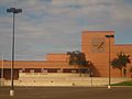
Zapata High School
-
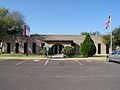
The Olga V. Figueroa Zapata County Public Library.
-
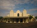
The new Our Lady of Lourdes Roman Catholic Church in Zapata.
-
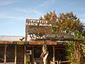
The rustic Frontier Ranch Museum on State Highway 16 in Zapata.
-
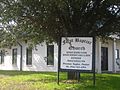
The First Baptist Church of Zapata.
-
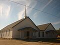
The United Methodist Church of Zapata.
-
The praying cowboy statue at Zapata Sesquicentennial Travel Park.
-
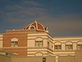
Side view of the Zapata County Courthouse.
-
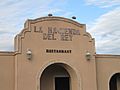
The former La Hacienda Del Rey restaurant in Zapata, now Mariscos El Jarocho.
-

The mariachi Herencia Mexicana band from San Antonio performing in Zapata.


_IMG_2036.JPG)


See also
 In Spanish: Zapata (Texas) para niños
