Freetown, New York facts for kids
Quick facts for kids
Freetown, New York
|
|
|---|---|

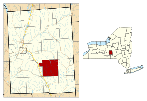
Location within Cortland County and New York
|
|
| Country | United States |
| State | New York |
| County | Cortland |
| Government | |
| • Type | Town Council |
| Area | |
| • Total | 25.63 sq mi (66.38 km2) |
| • Land | 25.49 sq mi (66.01 km2) |
| • Water | 0.14 sq mi (0.37 km2) |
| Elevation | 1,565 ft (477 m) |
| Population
(2010)
|
|
| • Total | 757 |
| • Estimate
(2016)
|
765 |
| • Density | 30.02/sq mi (11.59/km2) |
| Time zone | UTC-5 (Eastern (EST)) |
| • Summer (DST) | UTC-4 (EDT) |
| ZIP code |
13803
|
| Area code(s) | 607 |
| FIPS code | 36-023-27496 |
| GNIS feature ID | 0978974 |
Freetown is a small town located in Cortland County, New York, in the United States. It's found in the southeastern part of Cortland County, just southeast of the city of Cortland. In 2010, about 757 people lived here.
Contents
History of Freetown
Freetown is a place with a long history. It was once part of a larger area known as the Central New York Military Tract. This tract was a special land area.
People first started settling in this region around the year 1800. Freetown officially became its own town in 1818. Before that, it was part of a town called Cincinnatus. A couple of years later, in 1820, Freetown grew even bigger. It gained more land from the nearby town of Virgil.
Geography of Freetown
Freetown covers a total area of about 25.6 square miles (66.4 square kilometers). Most of this area is land, about 25.5 square miles (66.0 square kilometers). Only a small part, about 0.14 square miles (0.4 square kilometers), is water.
New York State Route 41 is an important road that goes through the northeastern part of Freetown. The town's water flows towards two rivers: the Otselic River to the east and the Tioughnioga River to the west. These rivers are just outside the town's borders. All the water in Freetown eventually flows into the larger Susquehanna River system.
People of Freetown
| Historical population | |||
|---|---|---|---|
| Census | Pop. | %± | |
| 1820 | 663 | — | |
| 1830 | 1,051 | 58.5% | |
| 1840 | 950 | −9.6% | |
| 1850 | 955 | 0.5% | |
| 1860 | 981 | 2.7% | |
| 1870 | 906 | −7.6% | |
| 1880 | 844 | −6.8% | |
| 1890 | 677 | −19.8% | |
| 1900 | 610 | −9.9% | |
| 1910 | 551 | −9.7% | |
| 1920 | 485 | −12.0% | |
| 1930 | 418 | −13.8% | |
| 1940 | 510 | 22.0% | |
| 1950 | 534 | 4.7% | |
| 1960 | 542 | 1.5% | |
| 1970 | 522 | −3.7% | |
| 1980 | 572 | 9.6% | |
| 1990 | 688 | 20.3% | |
| 2000 | 789 | 14.7% | |
| 2010 | 757 | −4.1% | |
| 2016 (est.) | 765 | 1.1% | |
| U.S. Decennial Census | |||
In the year 2000, there were 789 people living in Freetown. These people lived in 267 different homes. Out of these homes, 206 were families. The town had about 31 people living in each square mile.
Many homes in Freetown had children under 18 living there, about 39.7%. Most homes, 64.8%, were married couples living together. About 14.6% of all homes had just one person living alone.
The average age of people in Freetown was 34 years old. About 31.4% of the people were under 18. About 8.6% of the people were 65 years or older. For every 100 females, there were about 116 males.
Communities and Locations in Freetown
Freetown is home to several small communities and areas:
- East Freetown – This is a small hamlet located on NY Route 41. You can find it in the northeastern part of the town.
- Freetown Corners – This hamlet is located closer to the center of Freetown.
- Galatia – This hamlet is found at the southern border of the town. It is south of Freetown Corners.
- Texas Valley – This hamlet is near the southeastern part of the town, right at the town line.
See also
 In Spanish: Freetown (Nueva York) para niños
 | Aurelia Browder |
 | Nannie Helen Burroughs |
 | Michelle Alexander |


