
Galiuro Mountains facts for kids
Quick facts for kids Galiuro Mountains |
|
|---|---|

extensive Galiuro Wilderness at center-south
|
|
| Highest point | |
| Peak | Bassett Peak |
| Elevation | 7,663 ft (2,336 m) |
| Dimensions | |
| Length | 55 mi (89 km) NW-SE |
| Width | 15 mi (24 km) |
| Geography | |

Location in Arizona
|
|
| Country | United States |
| Settlements | Mammoth, Klondyke and Redington |
| Range coordinates | 32°35′12″N 110°19′48″W / 32.58667°N 110.33000°W |
| Topo map | Bassett Peak quad |
The Galiuro Mountains are a large mountain range located in southeast Arizona, United States. These mountains are part of a special group called "sky islands." A sky island is a mountain range that rises high above the surrounding desert. It creates a cooler, wetter climate at its top, like an island in the sky. This allows different plants and animals to live there compared to the hot desert below.
The Galiuro Mountains are known for being tall and rugged. They are part of the Madrean Sky Islands region, which stretches across parts of Arizona, northern Sonora in Mexico, and a small part of New Mexico. The Aravaipa Canyon Wilderness is found along the northern edge of the range. The large Galiuro Wilderness covers the central and southern parts. To the south, the Galiuro Wilderness touches the Redfield Canyon Wilderness. A river valley runs along the southwest side of the mountains. The Aravaipa Creek and its valley are on the northeast side.

Exploring the Galiuro Mountains
The Galiuro Mountains stretch from northwest to southeast. To the southwest, you'll find the San Pedro Valley and the San Pedro River. This valley is next to the large Santa Catalina Mountains, which are another sky island range. To the northeast, there's a narrower area called the Aravaipa Valley with the Aravaipa Creek.
The towns closest to the northwest part of the Galiuro Mountains are Mammoth, Arizona and San Manuel, Arizona. These towns are northeast of Tucson.
Tallest Peaks and Landforms
The highest point in the Galiuro Mountains is Bassett Peak. It stands at 7,663 feet (2,336 m) (about 2,336 meters) tall. In the Western Apache language, this peak is called Dził Nazaayú, which means "Mountain That Sits Here and There."
Other important peaks in the range, listed from north to south, include:
- Black Butte, which is 4,573 feet (1,394 m) (about 1,394 meters) high.
- Sixtysix Peak.
- Mescal Peak.
- Horse Mountain, reaching 6,225 feet (1,897 m) (about 1,897 meters).
- Maverick Mountain, at 7,003 feet (2,135 m) (about 2,135 meters).
- China Peak.
- Topout Peak.
- Kennedy Peak, standing 7,549 feet (2,301 m) (about 2,301 meters) tall.
- Sunset Peak.
- Saddle Mountain, at 6,167 feet (1,880 m) (about 1,879 meters).

Images for kids
-
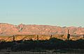
View of the Galiuros from near San Manuel
-
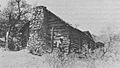
Power's Cabin, a historic site from 1918.
