Garber, Oklahoma facts for kids
Quick facts for kids
Garber, Oklahoma
|
|
|---|---|

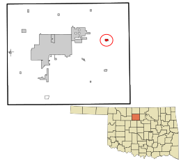
Location in Garfield County and the state of Oklahoma.
|
|
| Country | United States |
| State | Oklahoma |
| County | Garfield |
| Area | |
| • Total | 0.51 sq mi (1.31 km2) |
| • Land | 0.51 sq mi (1.31 km2) |
| • Water | 0.00 sq mi (0.00 km2) |
| Elevation | 1,175 ft (358 m) |
| Population
(2020)
|
|
| • Total | 725 |
| • Density | 1,432.81/sq mi (552.73/km2) |
| Time zone | UTC-6 (Central (CST)) |
| • Summer (DST) | UTC-5 (CDT) |
| ZIP code |
73738
|
| Area code(s) | 580 |
| FIPS code | 40-28500 |
| GNIS feature ID | 2410566 |
Garber is a small city in Garfield County, Oklahoma, United States. In 2020, about 725 people lived there. The city is named after Martin Garber. He was the father of Milton C. Garber, who was a U.S. congressman, a mayor, a newspaper editor, and a judge.
Before Garber became a city, the land was part of the Cherokee Outlet. This was a large area of land that belonged to the Cherokee Nation. In 1893, the U.S. government opened it up for people who were not Native American to settle there.
Contents
History of Garber
The Garber family took part in the Land Run of 1893. This was an event where people could claim land in Oklahoma. They claimed about 160 acres (0.65 square kilometers) of land. This land later became the city of Garber.
In 1899, a railroad called the Enid & Tonkawa Railway built tracks nearby. These tracks went from North Enid to Billings. In October 1899, Milton C. and Burton A. Garber created the Garber Town Company. They planned out the town. Burton Garber also partly owned the Garber Oil Company.
Ed Long (1934-2017) was born in Garber. He became a state senator in Oklahoma and was also a businessman.
Where is Garber?
Garber is located in the eastern part of Garfield County. It is about 19 miles (31 kilometers) east of Enid. Enid is the main city and county seat of Garfield County.
Two main roads, Oklahoma State Highways 15 and 74, pass through the west side of Garber. Highway 74 goes north to Lamont and south to Covington. Highway 15 goes south and west to Enid, and north and east to Billings.
The United States Census Bureau says that Garber covers a total area of about 0.51 square miles (1.3 square kilometers). All of this area is land.
People Living in Garber
| Historical population | |||
|---|---|---|---|
| Census | Pop. | %± | |
| 1910 | 382 | — | |
| 1920 | 1,446 | 278.5% | |
| 1930 | 1,356 | −6.2% | |
| 1940 | 1,086 | −19.9% | |
| 1950 | 957 | −11.9% | |
| 1960 | 905 | −5.4% | |
| 1970 | 1,101 | 21.7% | |
| 1980 | 992 | −9.9% | |
| 1990 | 959 | −3.3% | |
| 2000 | 845 | −11.9% | |
| 2010 | 822 | −2.7% | |
| 2020 | 725 | −11.8% | |
In 2000, there were 845 people living in Garber. There were 360 households and 244 families. The population density was about 1,721 people per square mile (664 people per square kilometer).
Most of the people in Garber were White (94.32%). There were also Native American (3.20%) and African American (0.24%) residents. Some people were from two or more races (2.01%). A small number of people were Hispanic or Latino (0.24%).
About 28.3% of households had children under 18 living with them. About 53.1% of households were married couples. The average household had 2.35 people.
The population was spread out by age. About 25.8% were under 18 years old. About 19.5% were 65 years or older. The average age was 39 years.
What Does Garber Do?
The main ways people make a living in Garber are through farming, oil, and raising cattle. Oil drilling started early, around 1904-1905. The Garber Oil and Gas Company, partly owned by Burton A. Garber, drilled Garber's first gas well in 1905.
The Garber Field, an area rich in oil, opened in 1916. This happened when the Hoy well started producing 200 barrels of oil per day. The most oil was produced in November 1925. By 1940, one well still held a state record for how much oil it first produced.
There were big "oil booms" in 1925 and 1927, which continued through the 1930s. By 1929, three oil refineries were operating in Garber. A refinery is a factory that cleans and processes oil. Because of the oil boom, Garber's population grew to about 2,200 people by 1920.
Schools in Garber
The local school district for Garber is called Garber Public Schools.
See also
 In Spanish: Garber (Oklahoma) para niños
 | William Lucy |
 | Charles Hayes |
 | Cleveland Robinson |


