Gardiner, New York facts for kids
Quick facts for kids
Gardiner
|
|
|---|---|
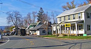
Downtown Gardiner
|
|
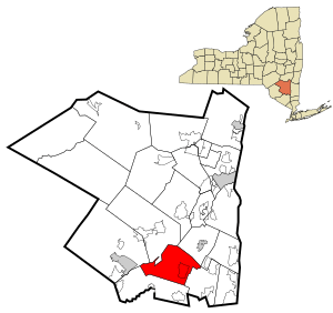
Location in Ulster County and the state of New York.
|
|
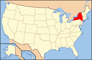
Location of New York within the United States
|
|
| Country | United States |
| State | New York |
| Region | Hudson Valley |
| County | Ulster |
| Area | |
| • Total | 43.95 sq mi (113.82 km2) |
| • Land | 43.44 sq mi (112.50 km2) |
| • Water | 0.51 sq mi (1.32 km2) |
| Population
(2020)
|
|
| • Total | 5,610 |
| • Density | 127.65/sq mi (49.29/km2) |
| Time zone | UTC-5 (Eastern (EST)) |
| • Summer (DST) | UTC-4 (EDT) |
| ZIP code |
12525 12561
|
| Area code(s) | 845 |
| FIPS code | 36-111-28255 |
Gardiner is a small town in the southern part of Ulster County, New York. It's located in the United States. In 2020, about 5,610 people lived here.
Contents
Discovering Gardiner's Past
The very first people to settle in this area were Huguenots. These were French Protestants who came here a long time ago.
Gardiner became its own town on April 2, 1853. It was formed from parts of three other towns: New Paltz, Rochester, and Denning. The town was named after Addison Gardiner, who was a high-ranking official called a Lieutenant Governor. In 1925, a big fire sadly destroyed much of Gardiner village.
Fun Places in Gardiner
The Wallkill Valley Rail Trail is a cool path that starts in southern Gardiner. It follows an old railroad track all the way to New Paltz. It's a great place for walking or biking!
You can also visit Majestic Park, which is off Farmer's Turnpike. This park has a skate park, a playground, and a gazebo. There are also picnic areas with barbecue grills, a baseball field, and courts for basketball and handball.
The Phillies Bridge Farm Project is a very old farm in New York state. It's still working today! This farm uses a special model called community-supported agriculture. This means people buy shares of the farm's harvest. The farm also works to help make sure everyone has access to good food.
Many historic buildings and places in Gardiner are listed on the National Register of Historic Places. These include the Peter Aldrich Homestead, Bevier House, and the Tuthilltown Gristmill. These places help us remember the town's long history.
Church of St. Charles Borromeo
The Church of St. Charles Borromeo in Gardiner has a long history too. It was officially opened in Gardiner in 1884. Before that, priests from nearby towns would visit Gardiner to hold services.
Gardiner's Geography
Gardiner is located right in the middle of Ulster County. It shares its borders with several other towns. To the north and west is Rochester. New Paltz is to the north, and Wawarsing is to the west. To the east, you'll find Plattekill, and to the south is Shawangunk.
The town covers about 44.9 square miles (116.3 square kilometers). Most of this area is land, with a small part being water.
The Wallkill River flows right through the center of Gardiner, from south to north. You can also find part of the Shawangunk Mountains in the western part of the town. These mountains are famous for their beautiful views and outdoor activities.
Gardiner's Climate
| Climate data for Gardiner, New York | |||||||||||||
|---|---|---|---|---|---|---|---|---|---|---|---|---|---|
| Month | Jan | Feb | Mar | Apr | May | Jun | Jul | Aug | Sep | Oct | Nov | Dec | Year |
| Record high °F (°C) | 69 (21) |
70 (21) |
86 (30) |
95 (35) |
94 (34) |
94 (34) |
100 (38) |
99 (37) |
96 (36) |
89 (32) |
80 (27) |
73 (23) |
100 (38) |
| Mean daily maximum °F (°C) | 34 (1) |
37 (3) |
46 (8) |
58 (14) |
70 (21) |
78 (26) |
83 (28) |
81 (27) |
73 (23) |
62 (17) |
50 (10) |
39 (4) |
59 (15) |
| Mean daily minimum °F (°C) | 13 (−11) |
15 (−9) |
25 (−4) |
36 (2) |
46 (8) |
55 (13) |
59 (15) |
58 (14) |
49 (9) |
37 (3) |
29 (−2) |
20 (−7) |
37 (3) |
| Record low °F (°C) | −27 (−33) |
−18 (−28) |
−13 (−25) |
12 (−11) |
27 (−3) |
33 (1) |
41 (5) |
35 (2) |
27 (−3) |
16 (−9) |
4 (−16) |
−14 (−26) |
−27 (−33) |
| Average precipitation inches (mm) | 3.24 (82) |
2.56 (65) |
3.57 (91) |
3.85 (98) |
4.62 (117) |
4.29 (109) |
4.25 (108) |
3.73 (95) |
4.09 (104) |
3.33 (85) |
3.75 (95) |
3.31 (84) |
44.59 (1,133) |
| Source: The Weather Channel | |||||||||||||
Population of Gardiner
| Historical population | |||
|---|---|---|---|
| Census | Pop. | %± | |
| 1860 | 2,096 | — | |
| 1870 | 1,991 | −5.0% | |
| 1880 | 1,794 | −9.9% | |
| 1890 | 1,703 | −5.1% | |
| 1900 | 1,509 | −11.4% | |
| 1910 | 2,779 | 84.2% | |
| 1920 | 1,088 | −60.8% | |
| 1930 | 988 | −9.2% | |
| 1940 | 1,317 | 33.3% | |
| 1950 | 1,289 | −2.1% | |
| 1960 | 1,660 | 28.8% | |
| 1970 | 2,598 | 56.5% | |
| 1980 | 3,552 | 36.7% | |
| 1990 | 4,278 | 20.4% | |
| 2000 | 5,238 | 22.4% | |
| 2010 | 5,713 | 9.1% | |
| 2020 | 5,610 | −1.8% | |
| Sources: 1880–1890, 1900–1920, 1930–1950, 1960–1980, 1990, 2000 2020 |
|||
In 2000, there were 5,238 people living in Gardiner. The population density was about 118 people per square mile. The average household had about 2.6 people living in it. The median age in the town was 38 years old.
Communities and Locations in Gardiner
Gardiner is made up of several smaller communities and areas:
- Benton Corners – a small community west of Gardiner village.
- Forest Glen – a community in the northern part of the town.
- Ganahgot – a community west of Gardiner village, where the Shawangunk Kill river meets the Wallkill River.
- Gardiner – the main village area.
- Ireland Corners – a community east of Gardiner village.
- Jenkinstown – a community in the northeastern part of the town.
- Libertyville – a community near the northern border of the town.
- Rutsonville – a community near the southern border of the town.
- Tuthill – a community west of Gardiner village, close to the Wallkill River.
- Wallkill Camp – a community in the northern part of the town.
Education in Gardiner
Students in Gardiner attend different school districts. Parts of the town are in the New Paltz Central School District. Other parts are in the Wallkill Central School District. A small area in the southwest is part of the Pine Bush Central School District.
See also
 In Spanish: Gardiner (Nueva York) para niños


