
Garrochales, Arecibo, Puerto Rico facts for kids
Quick facts for kids
Garrochales
|
|
|---|---|
|
Barrio
|
|

Cows (dairy is a mainstay industry of Arecibo and nearby Hatillo)
|
|

Location of Garrochales within the municipality of Arecibo shown in red
|
|

Garrochales, Arecibo, Puerto Rico
Location in Caribbean
|
|
| Commonwealth | |
| Municipality | |
| Area | |
| • Total | 5.34 sq mi (13.8 km2) |
| • Land | 5.32 sq mi (13.8 km2) |
| • Water | 0.02 sq mi (0.05 km2) |
| Elevation | 85 ft (26 m) |
| Population
(2010)
|
|
| • Total | 2,433 |
| • Density | 457.3/sq mi (176.6/km2) |
| Source: 2010 Census | |
| Time zone | UTC−4 (AST) |
Garrochales is a special kind of neighborhood, called a barrio, in Arecibo, Puerto Rico. Arecibo is a city located in the northeastern part of Puerto Rico. In 2010, about 2,433 people lived in Garrochales.
Where is Garrochales?
Garrochales is located in the northeastern part of the municipality of Arecibo. It shares its borders with several other areas.
To the north of Garrochales, you will find Islote barrio and the municipality of Barceloneta. Barceloneta is also to its east. To the south, Garrochales borders Sabana Hoyos barrio. Finally, to the west, it is next to Factor barrio.
What are Sectors?
In Puerto Rico, barrios are like smaller parts of a city or town. These barrios are then divided even further into smaller areas. These smaller areas are called sectores, which means sectors in English.
The types of sectors can be different. Some are simply called sector, while others might be named urbanización, reparto, barriada, or residencial. Each name describes a different kind of local area where people live.
Here are some of the sectors you can find in Garrochales barrio:
- Comunidad San Luis
- Sector Bethania
- Sector Bosque Cambalache
- Sector El Alto
- Sector El Salao
- Sector Factor II
- Sector La PRRA
- Sector Noriega
- Sector Sabana
- Sector Salao
- Sector San Luis
- Urbanización Haciendas de Garrochales
- Urbanización Jardines de Bethania
- Urbanización Villas de Garrochales
History and Population
Puerto Rico used to be controlled by Spain. After the Spanish–American War, Spain gave Puerto Rico to the United States. This happened under the rules of the Treaty of Paris of 1898. Puerto Rico then became an unincorporated territory of the United States.
In 1899, the United States Department of War took a count of the people in Puerto Rico. This count is called a census. The census found that 950 people lived in Garrochales barrio at that time.
Here is how the population of Garrochales has changed over the years:
| Historical population | |||
|---|---|---|---|
| Census | Pop. | %± | |
| 1900 | 950 | — | |
| 1910 | 1,338 | 40.8% | |
| 1920 | 970 | −27.5% | |
| 1930 | 1,421 | 46.5% | |
| 1940 | 1,580 | 11.2% | |
| 1950 | 1,585 | 0.3% | |
| 1980 | 1,965 | — | |
| 1990 | 2,176 | 10.7% | |
| 2000 | 2,366 | 8.7% | |
| 2010 | 2,433 | 2.8% | |
| U.S. Decennial Census 1899 (shown as 1900) 1910-1930 1930-1950 1980-2000 2010 |
|||
The main type of work and business in Garrochales is cattle farming and producing dairy products like milk.
Gallery
-
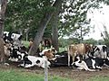
This picture shows the milk industry of Arecibo. You can see it near Sector Noriega, Jardines de Bethania, and Sector San Luis.

See also
 In Spanish: Garrochales (Arecibo) para niños
- List of communities in Puerto Rico
- List of barrios and sectors of Arecibo, Puerto Rico
