
Gaspereau Lake facts for kids
Quick facts for kids Gaspereau Lake |
|
|---|---|

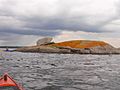
View from north shore
|
|

Gaspereau Lake
Location in Nova Scotia
|
|
| Location | Kings County, Nova Scotia |
| Coordinates | 44°59′N 64°32′W / 44.983°N 64.533°W |
| Primary outflows | Gaspereau River |
| Basin countries | Canada |
| Max. length | 12 km (7.5 mi) |
| Max. width | 7 km (4.3 mi) |
| Surface area | 22 km2 (8.5 sq mi) |
| Shore length1 | 55 km (34 mi) |
| Surface elevation | 185 m (607 ft) |
| Frozen | 3 months |
| Islands | 50 |
| Settlements | Welton Landing, Nova Scotia |
| 1 Shore length is not a well-defined measure. | |
Gaspereau Lake is a large lake located in Kings County, Nova Scotia, Canada. It sits about 10 kilometers (6 miles) south of the town of Kentville on the South Mountain. This lake is the biggest in Kings County and ranks as the fifth largest lake in all of Nova Scotia.
The lake is quite shallow and features many forested islands. It also has hundreds of small, rocky islets, which are sometimes called skerries.
Contents
Lake Water Levels and Flow
The amount of water in Gaspereau Lake is carefully managed by Nova Scotia Power. At the natural exit point of the Gaspereau River, located in the northeast part of the lake, there is a special control dam. This dam also has a fish ladder, which helps fish move past it.
Another control dam is found at the southeast corner of the lake. This dam directs water into a canal. The canal then sends water to hydroelectric power stations. These stations use the flowing water to create electricity for homes and businesses.
Fish Life in Gaspereau Lake
Every late spring, a special fish called the gaspereau (alewife) makes an amazing journey. These fish travel from the ocean, swimming up the Gaspereau River. They come to Gaspereau Lake to spawn, or lay their eggs, in the shallow waters. This yearly migration is very important for the lake's ecosystem.
Ancient History and Archaeology
The area around Gaspereau Lake is very important for understanding ancient history. Many archaeological sites have been found along the lake's shores. These sites show that people have lived here for a very long time. Some findings suggest people were here as early as 10,000 years ago. There is clear evidence of people living here continuously from at least 5,000 years ago until about 500 years ago, when Europeans first arrived.
Discoveries at End of Dyke Site
One of the most important sites is called the End of Dyke Site. It is the largest archaeological site in the Maine–Maritimes Region. This is because so many artifacts have been found there.
Archaeologists have discovered many interesting items at this site, including:
- Stone tools: These include sharp stone flakes, projectile points (like arrowheads), and scrapers used for preparing animal hides.
- Ground stone tools: These are tools that have been shaped and smoothed by grinding.
- Ceramics: Pieces of ancient pottery.
- Copper: Small pieces of copper, which was a valuable material.
- Red ochre paintstones: Stones used to make red paint.
- Shark's teeth: Showing connections to the ocean or trade.
- Faunal remains: Bones and other parts of animals, which tell us what people ate.
Many ancient hearths, or fire pits, have also been found. These show places where people cooked and gathered.
Toolstone and Trade Routes
The Gaspereau River, which flows out of the lake, also has many important archaeological findings. Both the lake and river areas contain a lot of a specific type of stone used for tools. This stone comes from the Minas Basin in the Bay of Fundy. This tells us that ancient people transported large amounts of this toolstone up the Gaspereau River. They then shaped it into tools and other artifacts. This shows an important trade and travel route used by early inhabitants.
Images for kids
-
Orange Lichen (Xanthoria elegans) on rocky islet in Gaspereau Lake
-
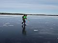
Nordic skating on Gaspereau Lake in winter


See also
 In Spanish: Lago Gaspereau para niños
