Georgetown, Beaver County, Pennsylvania facts for kids
Quick facts for kids
Georgetown, Pennsylvania
|
|
|---|---|

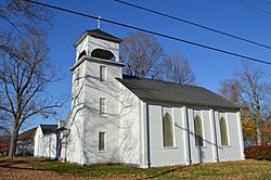
St. Luke's Anglican Church, built 1833
|
|

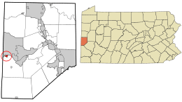
Location in Beaver County and the state of Pennsylvania.
|
|
| Country | United States |
| State | Pennsylvania |
| County | Beaver |
| Settled | 1793 |
| Incorporated | 1850 |
| Government | |
| • Type | Borough Council |
| Area | |
| • Total | 0.25 sq mi (0.65 km2) |
| • Land | 0.17 sq mi (0.45 km2) |
| • Water | 0.08 sq mi (0.20 km2) |
| Elevation | 741 ft (226 m) |
| Population
(2020)
|
|
| • Total | 208 |
| • Density | 1,188.57/sq mi (459.05/km2) |
| Time zone | UTC-5 (Eastern (EST)) |
| • Summer (DST) | UTC-4 (EDT) |
| Zip code |
15043
|
| Area code(s) | 724 |
| FIPS code | 42-28824 |
| GNIS feature ID | 1214876 |
Georgetown is a small town, called a borough, in western Beaver County, Pennsylvania, United States. It is located right along the Ohio River. In 2020, about 208 people lived there. Georgetown is part of the larger Pittsburgh metropolitan area. A very large waste area called Little Blue Run Lake, which holds coal waste, is located near the town.
Contents
History of Georgetown
The area around the Ohio River was once home to Native American groups like the Shawnee. French explorers and traders were the first Europeans to visit this region in the 1600s.
Early Explorers and Conflicts
In 1751, Christopher Gist was one of the first English colonists to explore the Ohio River area. Later, in 1753, George Washington also surveyed the land. He was sent to tell the French to leave the territory, which both the British and French claimed. These land arguments led to the French and Indian War in 1754.
After the war ended in 1763, the region became British land. The Province of Pennsylvania then gained control of the land through a treaty with Native Americans in 1768.
Settlement and Naming
After the American Revolutionary War ended in 1783, new settlers began moving into western Pennsylvania. Many traveled west from Pittsburgh along the Ohio River. The area where Georgetown is now was a "last chance" stop for travelers. They could get food and supplies before entering the wild and dangerous Northwest Territory. There was a war with Native Americans happening there at the time.
The town of Georgetown was officially started by Benoni Dawson on January 13, 1793. It was named 'Georgetown'. Some people believe it was named after Benoni's son, George Dawson. Others think it was named after the first U.S. President, George Washington, who had explored the area years before.
Settlement was slow at first because of fighting with Native Americans. But after a peace treaty in 1795, more people moved in. In 1800, Georgetown became part of the new Beaver County. The first post office and hotel opened in Georgetown in 1802.
Famous Visitors and Growth
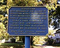
In 1803, Meriwether Lewis stopped in Georgetown. He was getting ready for the Lewis and Clark Expedition. Lewis bought a canoe here to replace a leaky one, though he later found the new one also leaked!
By 1812, the nearby Mill Creek was used to power mills that ground grain into flour. The first church, St. Luke's Episcopal Church, was built in 1814. Georgetown remained an important river town for boats until railroads and oil drilling became popular after the Civil War.
Georgetown's Location
Georgetown is located at 40°38′28″N 80°30′0″W / 40.64111°N 80.50000°W.
Land and Water
The borough covers about 0.3 square miles (0.78 km2) of land. A good portion of this area, about 0.1 square miles (0.26 km2), is water.
Neighboring Areas
Georgetown shares its land border only with Greene Township. This township is to the south, east, and west of Georgetown. Across the Ohio River to the north, Georgetown is next to the towns of Glasgow and Ohioville.
Population and People
| Historical population | |||
|---|---|---|---|
| Census | Pop. | %± | |
| 1860 | 295 | — | |
| 1870 | 297 | 0.7% | |
| 1880 | 288 | −3.0% | |
| 1890 | 274 | −4.9% | |
| 1900 | 271 | −1.1% | |
| 1910 | 269 | −0.7% | |
| 1920 | 251 | −6.7% | |
| 1930 | 260 | 3.6% | |
| 1940 | 253 | −2.7% | |
| 1950 | 246 | −2.8% | |
| 1960 | 246 | 0.0% | |
| 1970 | 234 | −4.9% | |
| 1980 | 231 | −1.3% | |
| 1990 | 194 | −16.0% | |
| 2000 | 182 | −6.2% | |
| 2010 | 174 | −4.4% | |
| 2020 | 208 | 19.5% | |
| Sources: | |||
In 2020, the population of Georgetown was 208 people. Looking back at the year 2000, there were 182 people living in 67 households. Most households were families, with many married couples. About 34% of households had children under 18 living there. The average household had about 2.7 people.
The population in 2000 was spread out by age:
- About 22% were under 18 years old.
- About 28% were between 25 and 44 years old.
- About 17% were 65 years or older.
The average age in Georgetown in 2000 was 40 years.
Local Industries
Georgetown is mostly a farming area. It is close to the big steel industries of Pittsburgh. However, Georgetown is also near other heavy industries that can sometimes have environmental impacts.
Little Blue Run Lake
In the 1970s, Little Blue Run Lake was created near Georgetown. It became the largest place in the country for storing waste from coal. Because of its large amount of pollution, the facilities closed down in 2016.
Nearby Industrial Sites
Georgetown is also a few miles downstream from old steel mills like J & L steel mills. Other industrial sites nearby include ATI Allegheny Ludlum, Marathon Petroleum, and the Beaver Valley Nuclear Power Plant.
Education in Georgetown
Children living in Georgetown attend schools in the South Side Area School District. The schools that serve Georgetown are:
- South Side Elementary School – for students in grades K–5
- South Side Middle School – for students in grades 6–8
- South Side High School – for students in grades 9–12
See also
In Spanish: Georgetown (Pensilvania) para niños
 | John T. Biggers |
 | Thomas Blackshear |
 | Mark Bradford |
 | Beverly Buchanan |


