
Georgetown, Minnesota facts for kids
Quick facts for kids
Georgetown, Minnesota
|
|
|---|---|
.jpg)
Georgetown, 1916
|
|

Location of Georgetown, Minnesota
|
|
| Country | United States |
| State | Minnesota |
| County | Clay |
| Incorporated | March 10, 1904 |
| Area | |
| • Total | 1.019 sq mi (2.639 km2) |
| • Land | 1.019 sq mi (2.639 km2) |
| • Water | 0.000 sq mi (0.000 km2) |
| Elevation | 883 ft (269 m) |
| Population
(2020)
|
|
| • Total | 86 |
| • Estimate
(2022)
|
88 |
| • Density | 84.40/sq mi (32.58/km2) |
| Time zone | UTC−6 (Central (CST)) |
| • Summer (DST) | UTC−5 (CDT) |
| ZIP Code |
56546
|
| Area code(s) | 218 |
| FIPS code | 27-23498 |
| GNIS feature ID | 2394883 |
| Sales tax | 7.375% |
Georgetown is a small city in Clay County, Minnesota, USA. It's located right by the Buffalo River, which flows into the Red River of the North. In 2020, about 86 people lived there.
Contents
A Look Back at Georgetown's History
Georgetown started as a trading post in 1859. It was set up by the Hudson's Bay Company, a very old company known for trading furs. A post office has been open in Georgetown since 1864. This means people have been sending and receiving mail there for a long time!
Georgetown's Location and Climate
Georgetown is a city that covers about 1.019 square miles (2.639 square kilometers) of land. There is no water area within the city limits.
Weather in Georgetown
Georgetown experiences a wide range of weather throughout the year. Here's a quick look at its climate:
| Climate data for Georgetown 1 E, Minnesota (1991–2020 normals, extremes 1962–present) | |||||||||||||
|---|---|---|---|---|---|---|---|---|---|---|---|---|---|
| Month | Jan | Feb | Mar | Apr | May | Jun | Jul | Aug | Sep | Oct | Nov | Dec | Year |
| Record high °F (°C) | 52 (11) |
54 (12) |
78 (26) |
100 (38) |
97 (36) |
101 (38) |
107 (42) |
102 (39) |
100 (38) |
94 (34) |
73 (23) |
57 (14) |
107 (42) |
| Mean daily maximum °F (°C) | 17.3 (−8.2) |
22.2 (−5.4) |
36.7 (2.6) |
54.4 (12.4) |
69.2 (20.7) |
78.2 (25.7) |
82.2 (27.9) |
80.9 (27.2) |
71.9 (22.2) |
56.1 (13.4) |
37.6 (3.1) |
23.3 (−4.8) |
52.5 (11.4) |
| Daily mean °F (°C) | 8.2 (−13.2) |
12.8 (−10.7) |
27.3 (−2.6) |
43.0 (6.1) |
56.7 (13.7) |
66.9 (19.4) |
70.7 (21.5) |
68.9 (20.5) |
60.1 (15.6) |
46.0 (7.8) |
29.3 (−1.5) |
15.2 (−9.3) |
42.1 (5.6) |
| Mean daily minimum °F (°C) | −0.9 (−18.3) |
3.4 (−15.9) |
17.9 (−7.8) |
31.7 (−0.2) |
44.3 (6.8) |
55.6 (13.1) |
59.3 (15.2) |
56.8 (13.8) |
48.3 (9.1) |
35.9 (2.2) |
20.9 (−6.2) |
7.1 (−13.8) |
31.7 (−0.2) |
| Record low °F (°C) | −40 (−40) |
−42 (−41) |
−24 (−31) |
−7 (−22) |
19 (−7) |
31 (−1) |
39 (4) |
30 (−1) |
21 (−6) |
6 (−14) |
−27 (−33) |
−35 (−37) |
−42 (−41) |
| Average precipitation inches (mm) | 0.74 (19) |
0.72 (18) |
1.21 (31) |
1.36 (35) |
2.86 (73) |
4.24 (108) |
3.84 (98) |
2.96 (75) |
2.88 (73) |
2.13 (54) |
0.77 (20) |
0.97 (25) |
24.68 (627) |
| Average snowfall inches (cm) | 7.9 (20) |
7.5 (19) |
5.7 (14) |
4.7 (12) |
0.0 (0.0) |
0.0 (0.0) |
0.0 (0.0) |
0.0 (0.0) |
0.0 (0.0) |
1.4 (3.6) |
3.5 (8.9) |
10.2 (26) |
40.9 (104) |
| Average precipitation days (≥ 0.01 in) | 5.3 | 5.9 | 4.6 | 5.0 | 8.1 | 10.0 | 8.2 | 6.5 | 5.7 | 5.6 | 4.7 | 6.7 | 76.3 |
| Average snowy days (≥ 0.1 in) | 5.3 | 5.6 | 3.7 | 1.1 | 0.0 | 0.0 | 0.0 | 0.0 | 0.0 | 0.6 | 3.6 | 6.6 | 26.5 |
| Source: NOAA | |||||||||||||
People Living in Georgetown
This section talks about the demographics of Georgetown. Demographics are facts about the people who live in a place, like how many there are, their ages, and how households are set up.
| Historical population | |||
|---|---|---|---|
| Census | Pop. | %± | |
| 1910 | 182 | — | |
| 1920 | 136 | −25.3% | |
| 1930 | 183 | 34.6% | |
| 1940 | 193 | 5.5% | |
| 1950 | 192 | −0.5% | |
| 1960 | 178 | −7.3% | |
| 1970 | 141 | −20.8% | |
| 1980 | 124 | −12.1% | |
| 1990 | 107 | −13.7% | |
| 2000 | 125 | 16.8% | |
| 2010 | 129 | 3.2% | |
| 2020 | 86 | −33.3% | |
| 2022 (est.) | 88 | −31.8% | |
| U.S. Decennial Census 2020 Census |
|||
Georgetown's Population in 2010
In 2010, there were 129 people living in Georgetown. These people lived in 48 different homes, and 33 of those were families. The city had about 129 people for every square mile.
Most of the people (95.3%) were White. A smaller number were Native American (2.3%) or from other races. About 3.9% of the population identified as Hispanic or Latino.
Out of the 48 homes:
- 37.5% had kids under 18 living there.
- 60.4% were married couples living together.
- About 25% of homes had just one person living in them.
- 10.5% had someone 65 years or older living alone.
The average age of people in Georgetown was 37.6 years old. About 31.8% of residents were under 18, and 6.2% were 65 or older. There were slightly more males (54.3%) than females (45.7%) in the city.
Images for kids
-
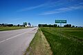
Georgetown is on U.S. Route 75
-
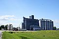
Georgetown Farmers Elevator Co. Established in 1911
-

US. Post Office, Georgetown, MN 56546


See also
 In Spanish: Georgetown (Minnesota) para niños
