
Gilead, Maine facts for kids
Quick facts for kids
Gilead, Maine
|
|
|---|---|

A view of Gilead in 1892
|
|

Gilead, Maine
Location in Maine

Gilead, Maine
Location in the United States
|
|
| Country | United States |
| State | Maine |
| County | Oxford |
| Area | |
| • Total | 19.67 sq mi (50.95 km2) |
| • Land | 18.88 sq mi (48.90 km2) |
| • Water | 0.79 sq mi (2.05 km2) |
| Elevation | 663 ft (202 m) |
| Population
(2020)
|
|
| • Total | 195 |
| • Density | 10/sq mi (4.0/km2) |
| Time zone | UTC-5 (Eastern (EST)) |
| • Summer (DST) | UTC-4 (EDT) |
| ZIP code |
04217
|
| Area code(s) | 207 |
| FIPS code | 23-27505 |
| GNIS feature ID | 0582490 |
Gilead is a small town in Oxford County, Maine, United States. It was named in 1804 because of the many Balm of Gilead trees found in the town center. In 2020, about 195 people lived in Gilead.
Contents
The Story of Gilead
In the late 1700s, the state of Massachusetts sold land to encourage people to move to what is now Maine. In 1772, some families from Massachusetts bought 6,000 acres of land. This area was first called Peabody's Patent.
By 1804, about 20 families lived there. They needed schools, churches, and roads. To get these things, they needed to raise money. So, on June 23, 1804, the area officially became the town of Gilead.
Exploring Gilead's Location
According to the United States Census Bureau, Gilead covers about 19.67 square miles (50.95 square kilometers). Most of this area is land, and a small part is water.
Gilead is the first town you reach in Maine if you are coming from New Hampshire on U.S. Route 2. This road is the main route through the town.
Who Lives in Gilead?
| Historical population | |||
|---|---|---|---|
| Census | Pop. | %± | |
| 1810 | 215 | — | |
| 1820 | 328 | 52.6% | |
| 1830 | 377 | 14.9% | |
| 1840 | 313 | −17.0% | |
| 1850 | 359 | 14.7% | |
| 1860 | 347 | −3.3% | |
| 1870 | 329 | −5.2% | |
| 1880 | 293 | −10.9% | |
| 1890 | 336 | 14.7% | |
| 1900 | 340 | 1.2% | |
| 1910 | 233 | −31.5% | |
| 1920 | 196 | −15.9% | |
| 1930 | 220 | 12.2% | |
| 1940 | 160 | −27.3% | |
| 1950 | 140 | −12.5% | |
| 1960 | 136 | −2.9% | |
| 1970 | 153 | 12.5% | |
| 1980 | 191 | 24.8% | |
| 1990 | 204 | 6.8% | |
| 2000 | 156 | −23.5% | |
| 2010 | 209 | 34.0% | |
| 2020 | 195 | −6.7% | |
| U.S. Decennial Census | |||
Gilead's Population in 2010
In 2010, the census showed that 209 people lived in Gilead. These people made up 98 households, and 59 of these were families. The town had 151 housing units.
Almost everyone in Gilead (100%) was White. About 1.9% of the population identified as Hispanic or Latino.
- 19.4% of households had children under 18.
- 54.1% were married couples living together.
- About 30.6% of all households were single people living alone.
- 17.4% of households had someone aged 65 or older living alone.
The average age in Gilead was 46.5 years.
- 16.7% of residents were under 18.
- 26.8% were between 25 and 44 years old.
- 22% were 65 years or older.
More males lived in Gilead (55.5%) than females (44.5%).
Images for kids
-
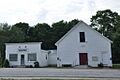
Gilead's Town Hall
-
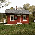
Gilead's former Grand Trunk Railroad station, built in 1851. It was returned to Gilead in 2001 after being in Auburn for 20 years.


See also
 In Spanish: Gilead (Maine) para niños
