
Gilpin Peak facts for kids
Quick facts for kids Gilpin Peak |
|
|---|---|
.jpg)
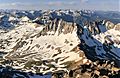
Gilpin Peak and Wright Lake
|
|
| Highest point | |
| Elevation | 13,700 ft (4,176 m) |
| Prominence | 720 ft (219 m) |
| Isolation | 1.20 mi (1.93 km) |
| Parent peak | Mount Sneffels |
| Naming | |
| Etymology | William Gilpin |
| Geography | |

Gilpin Peak
Location in Colorado
|
|
| Location | Ouray and San Miguel counties, Colorado, United States |
| Parent range | San Juan Mountains, Sneffels Range |
| Topo map | USGS 7.5' topographic map Grays Peak, Colorado |
Gilpin Peak is a tall mountain summit in the Sneffels Range. This mountain range is part of the larger Rocky Mountains in North America. Gilpin Peak is special because it is a "thirteener." This means its top is over 13,000 feet (about 3,962 meters) high. To be exact, it reaches 13,700-foot (4,176 m) above sea level.
The mountain is located in the Mount Sneffels Wilderness. This wilderness area is part of the Uncompahgre National Forest in Colorado, United States. Gilpin Peak sits on the border between Ouray County and San Miguel County. It is about 5.6 kilometers (3.5 miles) north-northeast of the Town of Telluride.
Who Was Gilpin Peak Named After?
Gilpin Peak was named to honor William Gilpin. He was a very important person in Colorado's history. William Gilpin was the first Governor of the Colorado Territory. A "territory" is an area of land that belongs to a country but is not yet a state. The governor is the leader of that territory or state.
Exploring the Area Around Gilpin Peak
Gilpin Peak is part of the Mount Sneffels Wilderness. This is a protected area where nature is kept wild. It's a great place for hiking and enjoying the outdoors. The wilderness is within the Uncompahgre National Forest. National forests are large areas of land managed by the government. They are used for recreation, wildlife protection, and sometimes for timber.
The mountain is also part of a "drainage divide." Imagine a line on the ground where rain or melting snow falls. On one side of the line, the water flows in one direction. On the other side, it flows in a different direction. That line is a drainage divide. For Gilpin Peak, it means water on one side flows into Ouray County, and on the other side, it flows into San Miguel County.
Images for kids
-
Gilpin Peak seen from the summit of Mount Sneffels

