
Glendon, Pennsylvania facts for kids
Quick facts for kids
Borough of Glendon
|
|
|---|---|

Glendon Borough Hall in July 2015
|
|

Location of Glendon in Northampton County, Pennsylvania (left) and of Northampton County in Pennsylvania (right)
|
|

Borough of Glendon
Location in Pennsylvania

Borough of Glendon
Location in the United States
|
|
| Country | |
| State | |
| County | Northampton |
| Area | |
| • City | 0.62 sq mi (1.60 km2) |
| • Land | 0.61 sq mi (1.59 km2) |
| • Water | 0.00 sq mi (0.00 km2) |
| Elevation | 230 ft (70 m) |
| Population
(2020)
|
|
| • City | 373 |
| • Density | 606.50/sq mi (234.09/km2) |
| • Metro | 865,310 (US: 68th) |
| Time zone | UTC-5 (EST) |
| • Summer (DST) | UTC-4 (EDT) |
| ZIP Code |
18042
|
| Area codes | 610 and 484 |
| FIPS code | 42-29568 |
| Primary airport | Lehigh Valley International Airport |
| Major hospital | St Lukes-Easton |
| School district | Wilson Area |
Glendon is a small town, called a borough, in Northampton County, Pennsylvania. In 2020, about 373 people lived there. Glendon is part of the Lehigh Valley area, which is home to over 860,000 people. It is one of the smallest towns in Northampton County.
Contents
History of Glendon
How Glendon Started
Before 1844, Glendon was just a few farms. That year, the Glendon Iron Works opened. This factory made iron. By 1856, the iron works was known for making very good quality iron. Because of this, many buildings were built for the workers.
The town grew quickly around the factory. By 1867, 141 people lived there. This was enough for it to become an official borough. This made the town grow even more. By 1870, the population jumped to 707 people.
Joseph Morrison, who came from Castle Toothery, Ireland, became the first leader, called a Chief Burgess. By 1880, about 1,000 people lived in Glendon. Around this time, the iron mining business started to slow down.
Life in the Company Town
Even though it was a factory town, Glendon was special. During the time known as the Gilded Age, the workers never went on strike. They also did not have a workers' union. The workers in Glendon earned good wages. Their pay was similar to what financial experts in big cities like Wall Street made.
The people of Glendon were also very traditional. They even started a local group of the Patriotic Order Sons of America, which is still active today. Despite being a small town, Glendon had its own police force. It also had a public school system for its children.
Glendon's Location and Size
Glendon is located at 40°39′44″N 75°14′9″W / 40.66222°N 75.23583°W. This means it is in the eastern part of Pennsylvania. The U.S. Census Bureau says the borough is about 0.6 square miles (1.6 square kilometers) in total. All of this area is land.
Getting Around Glendon

As of 2007, Glendon had about 4.33 miles (6.97 km) of public roads. Some of these roads are kept up by the Pennsylvania Department of Transportation (PennDOT). The rest are maintained by the borough itself.
A major highway, Interstate 78, goes through Glendon. It runs from southwest to northeast across the town. However, the closest exit for this highway is in the next town over, Williams Township. Some of the main roads in Glendon include Island Park Road, Main Street, and 25th Street.
People of Glendon
|
||||||||||||||||||||||||||||||||||||||||||||||||||||||||||||||||||||||||||||
In 2000, there were 367 people living in Glendon. These people lived in 139 homes. About 98 of these were families. The population density was about 574 people per square mile.
Most people in Glendon were White (95.64%). A smaller number were African American (0.82%) or Asian (1.36%). Some people were from other races or a mix of races. About 2.18% of the population was Hispanic or Latino.
In 2000, about 33.1% of homes had children under 18 living there. Most homes (58.3%) were married couples. About 23% of homes had just one person living there. The average home had 2.64 people.
The population was spread out by age:
- 28.9% were under 18 years old.
- 4.4% were 18 to 24 years old.
- 30.2% were 25 to 44 years old.
- 23.4% were 45 to 64 years old.
- 13.1% were 65 years or older.
The average age in Glendon was 36 years.
Schools in Glendon
Students in Glendon attend schools in the Wilson Area School District. Older students, from ninth to twelfth grade, go to Wilson Area High School in Easton.
Images for kids
-
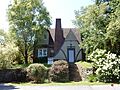
House on Franklin Street
-
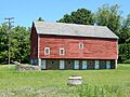
Barn on High Street


See also
 In Spanish: Glendon (Pensilvania) para niños
