Glenville, Minnesota facts for kids
Quick facts for kids
Glenville
|
|
|---|---|

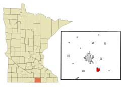
Location of Glenville, Minnesota
|
|
| Country | United States |
| State | Minnesota |
| County | Freeborn |
| Area | |
| • Total | 1.11 sq mi (2.88 km2) |
| • Land | 1.05 sq mi (2.73 km2) |
| • Water | 0.06 sq mi (0.16 km2) |
| Elevation | 1,224 ft (373 m) |
| Population
(2020)
|
|
| • Total | 568 |
| • Density | 539.41/sq mi (208.36/km2) |
| Time zone | UTC-6 (Central (CST)) |
| • Summer (DST) | UTC-5 (CDT) |
| ZIP code |
56036
|
| Area code(s) | 507 |
| FIPS code | 27-24056 |
| GNIS feature ID | 2394914 |
Glenville is a small city in Freeborn County, Minnesota, United States. It is located close to another city called Albert Lea. The city is also found along the Shell Rock River. In 2010, about 643 people lived in Glenville.
Contents
A Look Back: Glenville's History
Glenville was first planned out in 1856 and was known as Shell Rock back then. It officially became a city in 1898. The name Glenville was chosen by the people who ran the railroad company.
A railroad line, the Burlington, Cedar Rapids, and Northern Railroad, was built through Glenville in 1870. This helped the city grow and connect with other places.
Where is Glenville? (Geography)
Glenville covers a total area of about 1.18 square miles (3.06 square kilometers). Most of this area, about 1.12 square miles (2.90 square kilometers), is land. The rest, about 0.06 square miles (0.16 square kilometers), is water.
You can find Glenville along U.S. Highway 65 and Freeborn County Road 13. The major highway I-35 is also nearby, making it easy to travel to and from the city.
Who Lives in Glenville? (Population)
The number of people living in Glenville has changed over the years. Here's how the population has grown and shrunk:
| Historical population | |||
|---|---|---|---|
| Census | Pop. | %± | |
| 1900 | 351 | — | |
| 1910 | 368 | 4.8% | |
| 1920 | 379 | 3.0% | |
| 1930 | 449 | 18.5% | |
| 1940 | 615 | 37.0% | |
| 1950 | 672 | 9.3% | |
| 1960 | 643 | −4.3% | |
| 1970 | 740 | 15.1% | |
| 1980 | 851 | 15.0% | |
| 1990 | 778 | −8.6% | |
| 2000 | 720 | −7.5% | |
| 2010 | 643 | −10.7% | |
| 2020 | 568 | −11.7% | |
| U.S. Decennial Census | |||
A Snapshot from 2010
In 2010, there were 643 people living in Glenville. These people lived in 278 different homes. Most of the people living there were White. A small number of people were of Asian descent or from other backgrounds. About 2.3% of the population identified as Hispanic or Latino.
Out of the 278 homes, about 27% had children under 18 living there. More than half of the homes (51.8%) were married couples living together. Some homes had a single parent, either a mother (8.3%) or a father (4.3%). About 30% of homes had just one person living alone.
The average age of people in Glenville in 2010 was 44.2 years old. About 21% of the residents were under 18. Around 19% of the people were 65 years old or older. The population was almost evenly split between males (49%) and females (51%).
See also
 In Spanish: Glenville (Minnesota) para niños

