
Gold Belt Byway facts for kids
Quick facts for kids
[[File:|x70px|alt= marker]] |
|
|---|---|
| Lua error in Module:Infobox_road/map at line 15: attempt to index field 'wikibase' (a nil value). | |
| Highway system | |
| Colorado State Highways |

The Gold Belt Byway is a special road in Colorado. It's called a National Scenic Byway because it's super pretty! This road got its name because it goes through areas where people used to dig for gold. It links old gold mining towns to each other and to the Arkansas Valley.
Contents
A Glimpse into History
Long ago, many roads on the Gold Belt Byway were built to connect busy mining towns. These towns were full of life during the Pike's Peak Gold Rush. As you drive or bike along, you can still see old, empty mines and buildings. Some towns look just like they did when the gold ran out!
Exploring the Byway
The Gold Belt Byway is actually a mix of different roads. Many of them are dirt roads. They can be narrow and wind through cool places like deep canyons.
Phantom Canyon Road
Phantom Canyon Road is a very scenic drive. It connects Cañon City and Victor. This road goes right through Phantom Canyon. You'll even go through two tunnels and over three tall bridges! There are also many spots to camp. This road used to be a railroad track. It connected the towns of Florence and Cripple Creek. The road has some narrow parts and tall wooden bridges. It is not paved.
Shelf Road

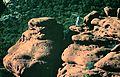
Shelf Road is another part of the byway. It goes through Fourmile Canyon. This road was first used by stagecoaches. Stagecoaches were like old-time buses pulled by horses. The tall cliffs near Shelf Road are famous for rock climbing. Many people come here to try sport climbing.
High Park Road
High Park Road was the very first route. It connected the gold mines to the Arkansas Valley. Unlike Shelf Road and Phantom Canyon Road, this road is completely paved. It also doesn't go through a canyon. High Park Road is in an area where people raise cattle. You might see cows grazing in the fields!
Teller County Road 1
Teller County Road 1 is often called Teller 1. It was the first stagecoach route to Cripple Creek. That's why it's called County Road 1! This road is paved. It offers many different kinds of views. For example, you can see steep mountains and rolling hills. Cattle often graze on these hills.
Gold Camp Road
Gold Camp Road follows an old railroad path. This railroad, called the "Short Line," went from Colorado Springs to Cripple Creek. In the 1920s, the railroad became a road for cars. At first, you had to pay a toll. Later, it became a free public road.
In 1988, one of the tunnels, tunnel #3, fell apart. It was never fixed. Because of this, cars can't use that part of the road anymore. Now, it's a popular spot for bikers and hikers. Car traffic was sent to a different road called Old Stage Road. This road is behind The Broadmoor. In 2013, a big flood washed away a large part of the road. This was between tunnels one and two. Some people say the tunnels are haunted! There are many stories about them.
Major Landmarks


Here are some big landmarks you can see along the Gold Belt Byway:
Images for kids
-
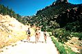
People cycling along the Gold Belt Tour Scenic and Historic Byway
-
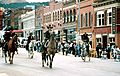
The historic downtown area of Cripple Creek Historic District
-
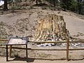
A petrified redwood stump in Florissant Fossil Beds National Monument
-
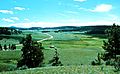
A view of Florissant Valley
-
A climber above the Shelf Road


