Golddust, Tennessee facts for kids
Quick facts for kids
Golddust, Tennessee
|
|
|---|---|
 |
|

Location in the State of Tennessee
|
|
| Country | United States |
| State | Tennessee |
| Counties | Lauderdale |
| Elevation | 249 ft (76 m) |
| Time zone | UTC-6 (CST) |
| • Summer (DST) | UTC-5 (CDT) |
| ZIP code |
38063 (Ripley, Tennessee)
|
| GNIS feature ID | 1285588 |
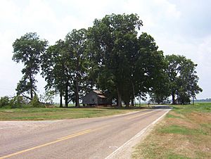
Golddust is a small, rural community in Lauderdale County, Tennessee, United States. It is an unincorporated community, meaning it does not have its own local government. Golddust is located right on the banks of the mighty Mississippi River. It is one of the oldest European-American settlements in Lauderdale County.
In 1864, a famous battle called the Battle of Fort Pillow happened about 3 miles south of Golddust.
Contents
History of Golddust
How Golddust Began
Golddust was founded in the 1820s. This makes it one of the very first places where European-American settlers built homes in Lauderdale County.
The Battle of Fort Pillow
In 1861, during the American Civil War, the Confederate States Army built strong defenses south of Golddust. They named this place Fort Pillow after General Gideon J. Pillow. This fort was very important because it overlooked the Mississippi River.
In 1862, the Union Army took control of the fort after the Confederates left. The Union Army stayed in control of Tennessee for the rest of the war. However, in 1864, Confederate Major General Nathan Bedford Forrest and his troops returned to Fort Pillow. They fought the Union soldiers there in what became known as the Battle of Fort Pillow. Many Union soldiers, especially African American troops, were killed during this battle. Forrest held the fort only for a short time before leaving again.
Today, Fort Pillow State Park is located about 3 miles south of Golddust. You can visit the park to learn more about this historical site.
Geography of Golddust
Golddust is located near Island No. 30 in the Mississippi River. This island is about 2.5 miles west of the community. The land around Golddust is mostly flat. It is part of the Mississippi River valley. This area often experiences flooding. Because of this, many homes in Golddust are built on stilts. This helps protect them from floodwaters.
Golddust is also located on the edge of the New Madrid Seismic Zone. This area has a higher risk of earthquakes.
Economy in Golddust
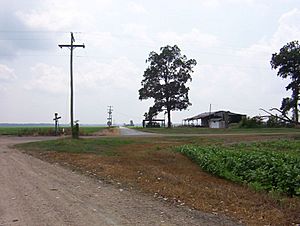
The main way people earn money around Golddust is through farming. Growing cotton is especially important here.
After slavery ended, many families, both black and white, worked as sharecroppers. Sharecropping meant they farmed a piece of land owned by someone else. In return, they would give the landowner a share of the crops they grew, usually cotton.
Since the early 1900s, new farming machines have changed things a lot. Machines like the cotton picker made it so fewer people were needed to work in the fields. Today, most cotton and other crops are grown on very large farms using modern machines.
As of 2007, there were no factories or big businesses in Golddust. The homes are spread out, and some are empty. You won't find signs marking the community's borders.
Infrastructure in Golddust
Tennessee State Route 19 is an important road that starts in Golddust, right at the Mississippi River. It then goes east through towns like Ripley and Nutbush. It continues on to Brownsville and eventually connects to Interstate 40.
 | May Edward Chinn |
 | Rebecca Cole |
 | Alexa Canady |
 | Dorothy Lavinia Brown |


