Golden Cap facts for kids
Quick facts for kids Golden Cap |
|
|---|---|

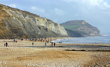
Golden Cap seen from Charmouth beach
|
|
| Highest point | |
| Elevation | 191 m (627 ft) |
| Prominence | 63 m (207 ft) |
| Parent peak | Hardown Hill |
| Geography | |
| Location | Dorset, England |
| Parent range | South Dorset Downs |
| OS grid | SY384934 |
| Topo map | OS Landranger 193 |

Golden Cap is a famous hill and cliff located on the coast of Dorset, England. It stands tall between the towns of Bridport and Charmouth. This amazing natural landmark is part of the English Channel coastline.
At 191 meters (about 627 feet) high, Golden Cap is one of the highest points along the south coast of Great Britain. You can see it from many miles away! It's a popular spot for hikers and nature lovers.
Contents
Golden Cap: A Famous Hill
Golden Cap is a well-known landmark in Dorset, England. It gets its name from the bright, golden-colored rock at the very top of the cliff. This special rock is called greensand.
The hill is owned by the National Trust, a charity that protects important places in England. Golden Cap is also part of the Jurassic Coast, which is a World Heritage Site. This means it's recognized as a very important place for everyone in the world to protect.
What Makes Golden Cap Special?
Golden Cap is special for several reasons. Its height makes it stand out along the coastline. You can reach the top by following a coastal path from Seatown. The walk usually takes about 40 minutes.
The views from the summit are incredible, stretching for miles along the coast. It's a great place to see the sea and the surrounding countryside.
Fossils and Geology at Golden Cap
The base of the cliff at Golden Cap is covered with many large rocks. This area is very popular with people who love to collect fossils. Over time, storms have uncovered amazing fossils here.
You can sometimes find fossilized ammonites and belemnites in the Blue Lias rock layer at the bottom of the cliff. These are ancient sea creatures that lived millions of years ago. Finding them helps us learn about Earth's past.
Exploring Golden Cap and Langdon Wood
Behind the main cliff of Golden Cap is an area called Langdon Wood. This is a small forest mainly filled with Corsican Pine trees. These trees were planted in the 1950s.
Langdon Wood is also owned by the National Trust. It has a circular walking path that is about one mile long. This walk is a great way to explore the area around Golden Cap and enjoy nature.
See also
 In Spanish: Golden Cap para niños
 | Emma Amos |
 | Edward Mitchell Bannister |
 | Larry D. Alexander |
 | Ernie Barnes |

