Goshen Valley facts for kids
Quick facts for kids Goshen Valley |
|
|---|---|

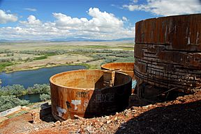
View of northeast valley from Warm Springs Mountain
|
|
| Length | 17 mi (27 km) N-S (see text) |
| Width | 11 mi (18 km) |
| Geography | |
| Country | United States |
| State | Utah |
| Regions | Great Basin Desert and Utah Valley |
| County | Utah |
| Communities |
List
|
| Borders on | Utah Lake, West Mountain, Juab Valley and East Tintic Mountains |
| River | Current Creek |
| Lake | Utah Lake |
The Goshen Valley is a long valley, about 17 miles (27 km) from north to south. It is located in southern Utah County, Utah. This valley helps form the southeast edge of Utah County, near the Wasatch Front and parts of the Wasatch Range mountains.
Think of Goshen Valley as an extension of Utah Valley, stretching southwest. A part of Utah Lake, called Goshen Bay, reaches into the valley. The western side of the valley goes north all the way to a place called Mosida (site), which is at the southern end of the Lake Mountains.
On the northeast side of the valley, along the shore of Goshen Bay, you'll find West Mountain. This mountain is part of the Wasatch Range. East of West Mountain is the southern part of Utah Valley. Goshen Valley is to the northwest, west, and southwest of West Mountain.
The southwest side of Goshen Valley is bordered by the East Tintic Mountains. Here, peaks like County Line Ridge mark the southwest border of Utah County. The mountains on the southeast side turn northeast to meet the southern part of Utah Valley, just east of West Mountain.
The town of Goshen, Utah is in the center-southeast of the valley. Santaquin is nearby to the northeast, close to the southern end of West Mountain.
What is Goshen Valley Like?
Goshen Valley is mostly flat and shaped like a triangle, stretching from north to south. The southern tip of the valley is nestled between the lower parts of the mountains on both sides.
To the northwest, the valley reaches the southwest shore of Utah Lake. It extends past Goshen Bay, which is an arm of the lake, all the way to Mosida. Mosida is located at the southern end of the Lake Mountains. Low hills border the valley in this area. These hills are mostly a branch of mountains coming from the East Tintic Mountains, connecting to the Lake Mountains.
The northeast part of the valley ends at the southwest side of West Mountain. This mountain forms a 9-mile (14 km) long ridge that acts as the eastern border of Goshen Bay. This bay is where the lake reaches south into Goshen Valley. Also, at the southwest of West Mountain, there are foothills and a marshy area. You can also find White Lake here, which is only about half a mile from Utah Lake, separated by a narrow strip of land.
Just south of West Mountain is another mountain called Warm Springs Mountain, which is 5,537 feet (1,688 m) tall. On its western side, you can see the old Tintic Standard Reduction Mill, which was once a mining operation. Next to it, to the west, is Warm Springs.
Current Creek and Water Areas
Many small streams flow into Goshen Valley from the mountains to the southwest and southeast. Current Creek flows north through the middle of the valley towards Utah Lake. A small water storage area called Goshen Reservoir is located upstream (south) on Current Creek, in the center-south of the valley.
The Current Creek Canal is found at the southern base of the valley's hills. It has sections for both the southwest and southeast foothills, each about 6 miles (9.7 km) long. The Mona Reservoir is located beyond the southeast hills, further upstream, in the very north of Juab Valley. Current Creek flows north through the northern half of Juab Valley.
 | Valerie Thomas |
 | Frederick McKinley Jones |
 | George Edward Alcorn Jr. |
 | Thomas Mensah |


