Lake Mountains facts for kids
Quick facts for kids Lake Mountains |
|
|---|---|

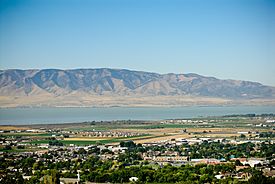
Looking west over Pleasant Grove and Utah Lake toward the Lake Mountains, September 2009
|
|
| Highest point | |
| Peak | Unnamed peak (at approximately the midpoint of the range) |
| Elevation | 7,690 ft (2,340 m) |
| Listing | List of mountains in Utah List of mountain ranges of Utah |
| Dimensions | |
| Length | 15 mi (24 km) N-S (arc-shape, curved east) |
| Width | 8 mi (13 km) (at center, narrower north/south) |
| Geography | |
| Country | United States |
| Communities | Eagle Mountain, Mosida and Saratoga Springs |
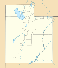
| Range coordinates | 40°16′30″N 111°54′02″W / 40.274892°N 111.900524°W |
| Topo map | USGS Saratoga Springs |
| Climbing | |
| Easiest route | Hike or road |
| Normal route | Lake Mountain Communications Road |
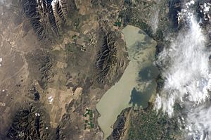
The Lake Mountains are a mountain range in Utah, United States. They are about 15 miles (24 km) long. These mountains are on the western side of the Utah Valley in Utah County. They form the northwest edge of Utah Lake. Because they are close to many towns, the mountains are used for important communication towers. Most of these towers are in the northern part, near Eagle Mountain.
Contents
Exploring the Lake Mountains

The Lake Mountains have a special arc shape, curving towards the east. They don't have one very tall, pointy peak. Instead, they have a central ridge line that is about 5 miles (8 km) long. The highest point in the range is an unnamed peak, reaching an elevation of 7,690 feet (2,344 meters).
The mountains are surrounded by other natural features. To the west is Cedar Valley. The Oquirrh Mountains are to the northwest. To the north are the Traverse Mountains. Utah Lake and the Utah Valley are to the northeast, east, and southeast. The Goshen Valley is to the south-southwest, and the East Tintic Mountains are to the southwest.
You can drive around the mountains on a few main roads. Utah State Route 68 (also called Redwood Road) runs along the eastern side, following the shore of Utah Lake. Utah State Route 73 goes along the northern edge. A dirt road called Lake Mountain Communications Road goes through the middle of the range. This road helps people get to the many radio towers on the mountains. There are also smaller dirt roads, like Soldiers Pass Road, on the southern end.
The mountains have many canyons, which are deep valleys with steep sides. On the east side, facing Utah Lake, there are seventeen named canyons. Some of these include Long, Miners, Limekiln, and Reformation canyons. On the west side, facing Cedar Valley, there are fewer named canyons, such as Mercer and Wiley canyons.
Why the Lake Mountains are Important for Communication
The Lake Mountains are a great spot for placing towers that help us communicate. These towers send out radio and television signals to cities like Provo, Orem, and American Fork. They serve almost all of Utah County.
Radio Stations on the Mountains
Many radio stations use towers on the Lake Mountains to broadcast their programs. For example, KENZ 94.9 FM, a popular music station, broadcasts from here. Other stations, like KJMY and KUDD, also use these mountains to reach listeners in the Provo-Orem metropolitan area. Some religious radio stations also have translators here, which help send their programs to more people.
Amateur (Ham) Radio
The Lake Mountains are also home to many "repeaters" for amateur radio, often called "ham radio." Ham radio is a hobby where people talk to each other using radio waves. Repeaters are special radios that receive signals from one ham radio operator and then re-send them over a wider area. This helps people communicate over longer distances. Important groups like the Utah Amateur Radio Club (UARC) and the Utah Valley Amateur Radio Club (UVARC) operate repeaters here.
Television Stations on the Mountains
Several television stations also have their towers on the Lake Mountains. These towers help broadcast TV channels to homes. For example, KUTH, which is the Univision channel for Salt Lake City, broadcasts its digital signal from here. Another station, K43JV, broadcasts programs from 3ABN.
Some TV stations have moved their transmitters from the Lake Mountains to Farnsworth Peak. This is because Farnsworth Peak is higher and closer to Salt Lake City, which helps them reach more viewers in the Wasatch Front area.
Internet Service Providers
The Lake Mountains are also a good location for internet service providers. These companies use the mountains to provide wireless internet to people living nearby. They also use the towers to send data between their different facilities. Some providers that use the mountains include Rise Broadband, InnovativeAir, SenaWave, and Avative Fiber.
 | Toni Morrison |
 | Barack Obama |
 | Martin Luther King Jr. |
 | Ralph Bunche |


