Goyder crater facts for kids

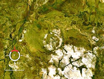
Landsat image of the central uplift of Goyder crater (circular feature in centre); screen capture from World Wind (scale is 3 km)
|
|
| Impact crater/structure | |
|---|---|
| Confidence | Confirmed |
| Diameter | 9–12 km (5.6–7.5 mi) |
| Age | <Mesoproterozoic |
| Exposed | Yes |
| Drilled | No |
| Location | |
| Location | Arnhem Land |
| Coordinates | 13°28′34″S 135°02′35″E / 13.476°S 135.043°E |
| Country | Australia |
| State | Northern Territory |
The Goyder crater is a very old impact site in Arnhem Land, Northern Territory, Australia. It was formed when a large space rock, like an asteroid or comet, crashed into Earth. This crash created a huge hole, or crater. Over millions of years, the crater has worn away due to erosion.
Today, what we see is the remaining part of this ancient impact. It is named after the nearby Goyder River. The original crater was likely about 9 to 12 kilometers (5.6 to 7.5 miles) wide.
What is the Goyder Crater?
The Goyder crater is an impact structure. This means it's the leftover part of a crater formed by a powerful impact. The crash happened in Mesoproterozoic times, hitting sedimentary rocks. These are rocks made from layers of sand and mud that hardened over time.
The area where the impact happened is now visible on the surface. You can see a ring of broken and cracked sandstone about 3 kilometers (1.9 miles) across. This ring is what's left of the crater's central uplift. A central uplift is like a rebound in the middle of a crater, where the ground bounces back up after the impact.
How Do We Know It's an Impact Crater?
Scientists have found special clues at the Goyder site that prove it was made by an impact. These clues include:
- Shatter cones: These are cone-shaped rocks with unique patterns. They form only under the extreme pressure of an impact.
- Shocked quartz: This is a type of quartz mineral that has been changed by the intense shock waves from an impact. It looks different under a microscope.
These signs are found in the broken sandstone at the center of the site. They tell us that a powerful event, like a space rock hitting Earth, created the Goyder crater.
When Did the Impact Happen?
It's hard to know the exact age of the Goyder impact. Scientists believe it happened more recently than 1,325 million years ago. This time period is known as the middle Mesoproterozoic Era. It is much older than the Cretaceous period, which was when dinosaurs lived.
Scientists use clues from rocks and magnetic surveys to estimate the age. The site is in a very remote area, making it difficult for scientists to visit and study.
 | Claudette Colvin |
 | Myrlie Evers-Williams |
 | Alberta Odell Jones |


