Granville, Vermont facts for kids
Quick facts for kids
Granville, Vermont
|
|
|---|---|

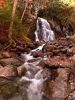
Moss Glen Falls in Granville
|
|

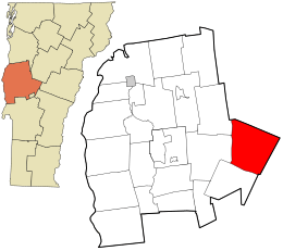
Location in Addison County and the state of Vermont.
|
|
| Country | United States |
| State | Vermont |
| County | Addison |
| Communities | Granville East Granville Lower Granville |
| Area | |
| • Total | 51.5 sq mi (133.4 km2) |
| • Land | 51.4 sq mi (133.2 km2) |
| • Water | 0.1 sq mi (0.3 km2) |
| Elevation | 1,801 ft (549 m) |
| Population
(2020)
|
|
| • Total | 301 |
| • Density | 6/sq mi (2.3/km2) |
| Time zone | UTC−05:00 (Eastern (EST)) |
| • Summer (DST) | UTC−04:00 (EDT) |
| ZIP Codes |
05747 (Granville)
05669 (Roxbury) |
| Area code | 802 |
| FIPS code | 50-29575 |
| GNIS feature ID | 1462108 |
Granville is a small town located in Addison County, Vermont, in the United States. In 2020, about 301 people lived there. The town was first called Kingston. It got its current name, Granville, in 1833.
In 2011, a big storm called Hurricane Irene caused a lot of flooding. Granville was one of thirteen towns in Vermont that became cut off because of the floods.
Contents
Exploring Granville's Location
Granville is in the eastern part of Addison County. The old village center is a bit north of the Town Hall. To the east, you can see the Braintree Ridge. The main part of the Green Mountains is to the west.
Roads and Rivers
Vermont Route 100 is a main road that goes through the town from north to south. This road passes through an area called the Granville Gulf. Here, you'll find the beginnings of two rivers: the White River, which flows south, and the Mad River, which flows north.
Neighboring Towns
To the north of Granville is the town of Warren. To the south, you'll find Hancock. There's also a part of Granville called East Granville. It's interesting because there isn't a direct road from East Granville to the main part of Granville or other places in Addison County. Another road, Vermont Route 12A, goes through East Granville. It connects to Roxbury in Washington County and Braintree in Orange County.
Hiking Trails
The Long Trail, a famous hiking path, goes through the western side of Granville for a short distance. It crosses the top of Little Hans Peak, which is about 3,348 feet (1,020 meters) high.
Land and Water
Granville covers a total area of about 51.5 square miles (133.4 square kilometers). Most of this area, about 51.4 square miles (133.2 square kilometers), is land. A very small part, about 0.1 square miles (0.3 square kilometers), is water.
People of Granville
Granville is a small community. In the year 2000, there were 303 people living in the town. These people lived in 127 different homes. The population density was about 5.8 people per square mile.
Who Lives Here?
- Most people in Granville are White (about 97.36%).
- A small number of people are African American (0.33%) or Native American (1.32%).
- Some people (0.66%) are from two or more racial backgrounds.
- About 0.99% of the population identified as Hispanic or Latino.
Households and Families
Out of the 127 homes in Granville:
- About 33.1% had children under 18 living there.
- About 46.5% were married couples living together.
- About 11.8% were homes where a mother lived with her children, but without a husband.
- About 28.3% of homes had only one person living there.
- About 4.7% of homes had someone 65 years or older living alone.
The average number of people in a household was 2.39. The average number of people in a family was 2.83.
Age Groups
The people in Granville are of different ages:
- About 24.4% were under 18 years old.
- About 5.9% were between 18 and 24 years old.
- About 34.7% were between 25 and 44 years old.
- About 23.4% were between 45 and 64 years old.
- About 11.6% were 65 years or older.
The average age of people in Granville was 38 years.
Learning in Granville
Students in Granville attend different schools depending on their grade level.
- Kids in Pre-Kindergarten and Kindergarten, and those in grades 5–6, go to the Granville/Hancock Village School in Granville.
- Students in grades 1–4 attend the Granville/Hancock Village School in Hancock.
- For grades 7–12, students can attend Harwood Union High School in South Duxbury, Whitcomb Junior/Senior High School in Bethel, or Rochester High School in Rochester.
Images for kids
See also
 In Spanish: Granville (Vermont) para niños
 | Percy Lavon Julian |
 | Katherine Johnson |
 | George Washington Carver |
 | Annie Easley |


