Roxbury, Vermont facts for kids
Quick facts for kids
Roxbury, Vermont
|
|
|---|---|
|
Town
|
|

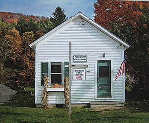
Roxbury Free Public Library
|
|

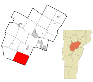
Location in Washington County and the state of Vermont
|
|

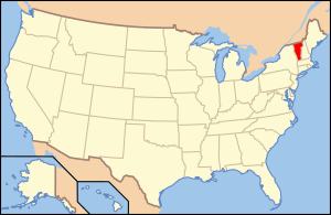
Location of Vermont with the U.S.A.
|
|
| Country | United States |
| State | Vermont |
| County | Washington |
| Chartered | 1781 (Vermont) |
| Communities |
|
| Area | |
| • Total | 41.8 sq mi (108.3 km2) |
| • Land | 41.8 sq mi (108.2 km2) |
| • Water | 0.04 sq mi (0.1 km2) |
| Elevation | 1,007 ft (495 m) |
| Population
(2020)
|
|
| • Total | 678 |
| • Density | 6.3/sq mi (2.4/km2) |
| Time zone | UTC-5 (EST) |
| • Summer (DST) | UTC-4 (EDT) |
| ZIP Codes | |
| Area code(s) | 802 |
| FIPS code | 50-60625 |
| GNIS feature ID | 1462190 |
Roxbury is a small town in Washington County, Vermont. It was officially created on August 6, 1781. In 2020, about 678 people lived here.
Contents
Geography and Nature
Roxbury covers about 41.8 square miles (108.3 square kilometers). Most of this area is land, with only a tiny bit of water.
Where is Roxbury Located?
Roxbury is the southernmost town in Washington County. It shares borders with other towns like Northfield to the north and Warren to the west. The town is about 25 miles (40 kilometers) southwest of Montpelier, which is Vermont's capital city.
A road called Vermont Route 12A runs through Roxbury from north to south. The town is also where two rivers, the Dog River and the White River, begin. The Dog River flows north, and the White River flows south. The exact middle point of Vermont is just three miles east of Roxbury village.
Mountains and Forests
Roxbury is a very mountainous and forested area. It has some of the roughest land in the region. More than 85% of the town is covered in forests. This includes about 5,500 acres (2,200 hectares) of state-owned land. There are also over 7,000 acres (2,800 hectares) of private land used for conservation.
Many spots in Roxbury are higher than 2,000 feet (610 meters) above sea level. The lowest point is about 880 feet (268 meters) along the White River. The highest point is 3,086 feet (941 meters) at the top of Rice Mountain. Rice Mountain is part of the Green Mountains.
History of Roxbury
Roxbury was officially given its name by the Vermont General Assembly in 1781. Its name probably comes from Roxbury, Massachusetts, which is now part of Boston. The town was chartered on August 6, 1781, to Benjamin Edwards and 64 other people. However, only 20 of these people ever actually lived in the town. The first European settlers arrived in 1789. The first town meeting was held in 1797.
Population Changes Over Time
The town grew steadily for the first 60 years of the 1800s. Its population went from 113 people in 1800 to its highest point of 1,060 people in 1860. This was just before the American Civil War. During the war, 94 men from Roxbury served, and 29 of them died.
Roxbury's population dropped in the 1900s, especially after World War II. The town's marble quarries, which opened in 1857, closed in 1957. The population reached its lowest point in 1970, with only 354 residents. However, the town has grown again since then. By 2010, the population had risen to 691.
Economy and Jobs
In the past, Roxbury's economy relied a lot on getting resources from the land. Important activities included farming, cutting down trees (logging), fishing, and quarrying (digging for stone). Digging for Verde Antique marble and talc was very important in Roxbury's history. Today, there is one company that digs for sand and gravel in the town. The marble quarries operated from 1857 to 1957.
Modern Work Life
Today, most people who live in Roxbury (about 80%) work outside the town. Since the 1970s, many Roxbury residents have traveled to Montpelier and Barre for their jobs.
The Central Vermont Public Service Corporation and the Washington Electric Co-op provide electricity to the town. Some residents live "off-the-grid" and use alternative energy sources like solar power.
Fun Places to Visit
- Roxbury State Fish Hatchery: This was Vermont's first fish hatchery, built in 1891. It used to attract up to 2,800 visitors every summer. However, it was badly damaged by Hurricane Irene in August 2011. The state is now rebuilding it.
- Historic Cemeteries: There are several old cemeteries in town. These include First Settlers, Orcutt, West Hill, Village, East Roxbury, and Roxbury Flats.
- Local Historical Society: This group has a collection of old items from Roxbury's history. Their office is in a small building that used to be the Town Clerk's Office.
- Camp Windridge at Teela Wooket: This is a private camp where kids can learn tennis, soccer, and horseback riding. It started in 1913 as a camp just for girls.
- Roxbury Free Library: The town's library has about 5,000 books for everyone to enjoy.
Population Information
| Historical population | |||
|---|---|---|---|
| Census | Pop. | %± | |
| 1800 | 113 | — | |
| 1810 | 361 | 219.5% | |
| 1820 | 512 | 41.8% | |
| 1830 | 737 | 43.9% | |
| 1840 | 784 | 6.4% | |
| 1850 | 967 | 23.3% | |
| 1860 | 1,060 | 9.6% | |
| 1870 | 916 | −13.6% | |
| 1880 | 938 | 2.4% | |
| 1890 | 768 | −18.1% | |
| 1900 | 712 | −7.3% | |
| 1910 | 618 | −13.2% | |
| 1920 | 609 | −1.5% | |
| 1930 | 594 | −2.5% | |
| 1940 | 554 | −6.7% | |
| 1950 | 465 | −16.1% | |
| 1960 | 364 | −21.7% | |
| 1970 | 354 | −2.7% | |
| 1980 | 452 | 27.7% | |
| 1990 | 575 | 27.2% | |
| 2000 | 576 | 0.2% | |
| 2010 | 691 | 20.0% | |
| 2020 | 678 | −1.9% | |
| U.S. Decennial Census | |||
In 2000, there were 576 people living in Roxbury. About 227 households and 163 families lived there. The town had about 13.8 people per square mile. Most of the people (94.10%) were White.
About 30% of households had children under 18. Most households (63%) were married couples. The average household had 2.54 people.
The population was spread out by age:
- 24% were under 18.
- 6.1% were 18 to 24.
- 29.5% were 25 to 44.
- 31.1% were 45 to 64.
- 9.4% were 65 or older.
The average age in Roxbury was 40 years old. For every 100 females, there were about 101.4 males.
Notable People from Roxbury
- Gideon Hixon: A businessman and politician in Wisconsin, born in Roxbury.
- Ed Pincus: A documentary filmmaker who lived and died in Roxbury.
- Francis V. Randall: An officer in the Union Army during the American Civil War.
- Zed S. Stanton: A Vermont lieutenant governor and judge who lived in Roxbury his whole life.
See also
 In Spanish: Roxbury (Vermont) para niños
 | Delilah Pierce |
 | Gordon Parks |
 | Augusta Savage |
 | Charles Ethan Porter |

