
Rochester, Vermont facts for kids
Quick facts for kids
Rochester, Vermont
|
|
|---|---|
|
Town
|
|

Civil War memorial in The Park in the center of town
|
|
| Motto(s):
The heart of the Green Mountains
|
|

Location in Windsor County and the state of Vermont.
|
|

Rochester, Vermont
Location in the United States
|
|
| Country | United States |
| State | Vermont |
| County | Windsor |
| Chartered | 1781 |
| Communities |
|
| Area | |
| • Total | 57.4 sq mi (148.6 km2) |
| • Land | 57.1 sq mi (147.8 km2) |
| • Water | 0.3 sq mi (0.8 km2) |
| Elevation | 878 ft (620 m) |
| Population
(2020)
|
|
| • Total | 1,099 |
| • Density | 19.155/sq mi (7.396/km2) |
| Time zone | UTC-5 (EST) |
| • Summer (DST) | UTC-4 (EDT) |
| ZIP code |
05767
|
| Area code(s) | 802 |
| FIPS code | 50-60100 |
| GNIS feature ID | 1462188 |
Rochester is a small town in Windsor County, Vermont, United States. About 1,099 people lived there in 2020. The main part of the town is also known as the Rochester census-designated place.
Rochester is located near the Green Mountain National Forest. It is a beautiful place that many tourists like to visit.
Contents
History of Rochester
Rochester was officially created in 1780. It was given a charter in 1781 to Dudley Chase, Asa Whitcomb, and 63 other people. The town was organized in 1788. The first settlers arrived in the winter of 1781–1782. They were David Currier and his family.
Over the years, Rochester grew by adding parts of nearby towns.
- In 1806, it added land from Pittsfield.
- In 1824, it added more from Pittsfield and a piece of Braintree.
- In 1834, it gained land from Hancock.
- Finally, in 1847, it annexed part of Goshen.
The town has many mountains, but the flat areas along the White River were good for farming. There were also places with water power for mills. By 1859, Rochester had 1,493 people. Its industries included a gristmill (for grinding grain), several sawmills (for cutting wood), and other shops.
A railroad called the White River Railroad reached Rochester in 1900. However, it closed in 1933 during the Great Depression.
In 2011, Hurricane Irene caused major flooding. Rochester was one of thirteen Vermont towns that became isolated because of the floods.
Rochester High School and Middle School closed in 2018. The school had been in Rochester since 1886. The building used since 1974 is no longer a school.
Geography and Climate
Rochester covers about 148.6 square kilometers (57.4 square miles). Most of this area, 147.8 square kilometers (57.1 square miles), is land. Only a small part, 0.8 square kilometers (0.3 square miles), is water. The White River flows through Rochester.
Two main roads cross the town: Vermont Route 73 and Vermont Route 100.
Rochester's Weather Patterns
Rochester has a humid continental climate. This means it has big changes in temperature throughout the year. Summers are warm to hot and often humid. Winters are cold, sometimes very cold. This type of climate is known as "Dfb" in the Köppen system.
| Climate data for Rochester, Vermont (1991–2020 normals, extremes 1964–2020) | |||||||||||||
|---|---|---|---|---|---|---|---|---|---|---|---|---|---|
| Month | Jan | Feb | Mar | Apr | May | Jun | Jul | Aug | Sep | Oct | Nov | Dec | Year |
| Record high °F (°C) | 64 (18) |
70 (21) |
82 (28) |
91 (33) |
92 (33) |
95 (35) |
95 (35) |
98 (37) |
95 (35) |
84 (29) |
75 (24) |
68 (20) |
98 (37) |
| Mean daily maximum °F (°C) | 29.2 (−1.6) |
32.1 (0.1) |
40.6 (4.8) |
54.1 (12.3) |
67.3 (19.6) |
75.1 (23.9) |
79.4 (26.3) |
78.3 (25.7) |
71.7 (22.1) |
58.5 (14.7) |
46.4 (8.0) |
34.5 (1.4) |
55.6 (13.1) |
| Daily mean °F (°C) | 18.9 (−7.3) |
20.5 (−6.4) |
29.0 (−1.7) |
41.9 (5.5) |
53.9 (12.2) |
62.5 (16.9) |
67.2 (19.6) |
66.0 (18.9) |
59.1 (15.1) |
47.1 (8.4) |
36.6 (2.6) |
25.5 (−3.6) |
44.0 (6.7) |
| Mean daily minimum °F (°C) | 8.7 (−12.9) |
8.8 (−12.9) |
17.3 (−8.2) |
29.7 (−1.3) |
40.5 (4.7) |
49.8 (9.9) |
55.0 (12.8) |
53.8 (12.1) |
46.6 (8.1) |
35.8 (2.1) |
26.8 (−2.9) |
16.4 (−8.7) |
32.4 (0.2) |
| Record low °F (°C) | −32 (−36) |
−28 (−33) |
−21 (−29) |
1 (−17) |
21 (−6) |
30 (−1) |
35 (2) |
33 (1) |
23 (−5) |
9 (−13) |
−2 (−19) |
−30 (−34) |
−32 (−36) |
| Average precipitation inches (mm) | 3.49 (89) |
2.82 (72) |
3.38 (86) |
3.81 (97) |
3.85 (98) |
5.24 (133) |
5.09 (129) |
4.45 (113) |
3.93 (100) |
4.96 (126) |
3.73 (95) |
4.12 (105) |
48.87 (1,241) |
| Average snowfall inches (cm) | 18.4 (47) |
17.4 (44) |
15.5 (39) |
3.6 (9.1) |
0.0 (0.0) |
0.0 (0.0) |
0.0 (0.0) |
0.0 (0.0) |
0.0 (0.0) |
0.5 (1.3) |
2.8 (7.1) |
17.3 (44) |
75.5 (192) |
| Average precipitation days (≥ 0.01 in) | 8.7 | 8.1 | 8.5 | 10.7 | 13.1 | 14.3 | 12.9 | 11.0 | 10.0 | 12.9 | 9.4 | 10.5 | 130.1 |
| Average snowy days (≥ 0.1 in) | 7.0 | 6.5 | 4.9 | 1.2 | 0.0 | 0.0 | 0.0 | 0.0 | 0.0 | 0.4 | 1.7 | 7.0 | 28.7 |
| Source: NOAA | |||||||||||||
Population of Rochester
| Historical population | |||
|---|---|---|---|
| Census | Pop. | %± | |
| 1790 | 215 | — | |
| 1800 | 524 | 143.7% | |
| 1810 | 911 | 73.9% | |
| 1820 | 1,148 | 26.0% | |
| 1830 | 1,392 | 21.3% | |
| 1840 | 1,396 | 0.3% | |
| 1850 | 1,493 | 6.9% | |
| 1860 | 1,507 | 0.9% | |
| 1870 | 1,444 | −4.2% | |
| 1880 | 1,362 | −5.7% | |
| 1890 | 1,257 | −7.7% | |
| 1900 | 1,250 | −0.6% | |
| 1910 | 1,317 | 5.4% | |
| 1920 | 1,397 | 6.1% | |
| 1930 | 1,285 | −8.0% | |
| 1940 | 1,129 | −12.1% | |
| 1950 | 937 | −17.0% | |
| 1960 | 879 | −6.2% | |
| 1970 | 884 | 0.6% | |
| 1980 | 1,054 | 19.2% | |
| 1990 | 1,181 | 12.0% | |
| 2000 | 1,171 | −0.8% | |
| 2010 | 1,139 | −2.7% | |
| 2020 | 1,099 | −3.5% | |
| U.S. Decennial Census | |||
In 2000, there were 1,171 people living in Rochester. These people lived in 511 households. About 28% of these households had children under 18. Most people in Rochester were White (98.46%).
The average age in Rochester was 43 years old. About 22% of the population was under 18. About 18% of the population was 65 or older.
The average income for a household in Rochester was $35,820. For families, it was $41,131. A small number of families (4.2%) and people (6.0%) lived below the poverty line.

Places to Visit
- Green Mountain National Forest: This large forest is a great place for outdoor activities.
Famous People from Rochester
Many interesting people have connections to Rochester:
- Barbara Fiske Calhoun: An artist and cartoonist during World War II. She also helped start the Quarry Hill Creative Center.
- William Wildman Campbell: A US congressman from Ohio.
- Irving Fiske: A playwright who also helped create the Quarry Hill Creative Center in Rochester.
- Robert H. Gardner: A filmmaker who was nominated for an Academy Award. He lives in Rochester.
- Jeremiah Ingalls: An early American composer.
- William B. Martin: He served as the Secretary of State for Iowa.
- Edna Chaffee Noble: A well-known speaker and teacher of elocution.
- Steve Reich: A famous American composer.
- James Whitcomb: A US senator and the eighth governor of Indiana.
- Tom Wicker: A well-known US journalist.
Images for kids
-
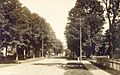
Main Street in 1912
-
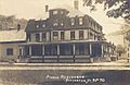
Pierce residence around 1915
-
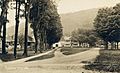
Street scene around 1915
-
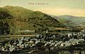
The village, early 1900s


See also
 In Spanish: Rochester (Vermont) para niños
