
Grasse River facts for kids
Quick facts for kids Grass River |
|
|---|---|
| Other name(s) | Grasse River |
| Country | |
| State | |
| Physical characteristics | |
| Main source | Middle Branch Grass River, South Branch Grass River |
| River mouth | St. Lawrence River Massena, New York 171 ft (52 m) 44°59′12″N 74°46′14″W / 44.9868°N 74.7706°W |
| Length | 73 mi (117 km) |
| Basin features | |
| Basin size | 619 sq mi (1,600 km2) |
| Tributaries |
|
The Grass River (also known as the Grasse River) is a 73-mile (117 km) long river in northern New York. It flows mainly northeast from the Adirondack Mountains into the St. Lawrence River. The Grass River is part of the larger St. Lawrence River Drainage Basin. Other rivers in this basin include the Oswegatchie and Raquette rivers.
The river got its name from François Joseph Paul de Grasse. He was a French admiral and a hero during the American Revolutionary War. He helped the American forces win an important battle, which led to the end of the war.
Contents
Where the River Starts
The Grass River begins in the northern part of New York. It starts from many small ponds, lakes, and streams. These are found in towns like Russell, Clare, and Clifton.
There are two main starting points, called branches:
- The Southern Branch is the stronger one. It flows from Moosehead Pond and Little Moosehead Pond.
- The Northern Branch is smaller. It gets water from ponds like Clear Pond and Horseshoe Pond. This branch runs through the Grasse River Wild Forest Reserve.
These two branches meet in the town of Russell. From there, they form the main part of the river, which grows bigger as it flows northeast.
This area of New York was first explored in the 1790s. A rich merchant named Alexander Macomb bought a huge amount of land from New York State. The area was known for its thick pine forests, stone quarries, and different kinds of ores (minerals). Later, the forests were cleared for farming and then for factories.
The River's Journey
The Grass River, like other rivers flowing into the St. Lawrence River, was once used to power many mills. Today, most of these mills are gone. But you can still find old stone foundations and other structures along the riverbanks. There are also several old dams along the Grass River. Its "twin" river, the Raquette, has many hydropower dams, both old and new.
The Grass River flows through several small towns and two larger ones: Massena and Canton.
- From Russell, where its two branches meet, the river flows into the village of Canton.
- It then passes through small places like Morley and Bucks Bridge.
- Next, it reaches the town of Madrid.
In Madrid, there is a major dam near New York State Route 345. South of this dam is the Madrid Municipal Park, which hosts fun events in the summer. The river then flows north towards Chase Mills. This area is close to Coles Creek State Park on the St. Lawrence River.
From Chase Mills, the river turns northeast into the town of Louisville. Here, you might see small rapids or waterfalls, depending on how much water is flowing. The river then enters the village of Massena.
The Grass River forms the northern edge of Massena's downtown area. In Massena, there's another important dam, often called the "weir". It's only about 3–4 feet (1 meter) tall. In the late 1990s, part of this dam broke.
The river continues through Massena to its eastern side. Here, the old Massena Power Canal connects to the river. This canal was built in the 1900s by the Pittsburgh Reduction Company (now called Alcoa). It connected the Grass River to the St. Lawrence River to power a hydropower dam. This dam was one of the first ten hydro-dams in the U.S. It stopped working in 1956 when the St. Lawrence River was flooded for the St. Lawrence Seaway Project.
The part of the river from the old powerhouse to its mouth in the St. Lawrence River is calm and flat. This is the only section where motorboats can easily travel. At the mouth of the Grass River is Snell Lock, which is part of the St. Lawrence Seaway shipping system.
River Cleanup Efforts
The lower part of the Grass River has had some pollution, especially near the old powerhouse and a drainage area from the Alcoa factory. Alcoa has been working for years to clean up this section of the river.
One early cleanup idea was to "cap" the river bottom. This meant covering the bottom to stop chemicals from spreading. However, this plan didn't work as well as hoped. Large pieces of ice flowing down the river caused damage to the cap. This ice also caused a lot of erosion along the riverbanks.
Current Cleanup Plans
In 2005, a company was hired by Alcoa to remove chemicals from the riverbed. They removed the river bottom, cleaned it, and placed the cleaned material in a special landfill on Alcoa's property.
Alcoa is also looking for ways to stop large ice chunks from damaging the river. Some ideas include:
- Building large barriers in Louisville.
- Repairing or rebuilding the downtown weir in Massena. This is tricky because the weir is privately owned.
- A newer idea is to build a small hydroelectric dam with one turbine about half a mile downstream from the old weir.
Images for kids
-

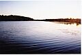
The Grasse River upstream of Massena, near Highway 56
-
The Grasse River in Massena Center
-
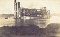
Dredging of the Grasse River
-
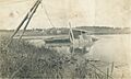
Sinking of the Steamer Sirius on the Grasse River
-
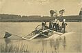
Another view of the Steamer Sirius


