Grave Creek (Oregon) facts for kids
Quick facts for kids Grave Creek |
|
|---|---|

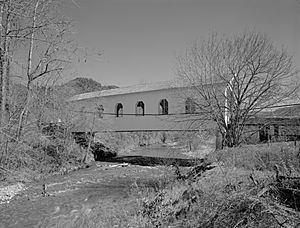
Grave Creek Bridge carries Sunny Valley Loop Road over the creek.
|
|
|
Location of the mouth of Grave Creek in Oregon
|
|
| Country | United States |
| State | Oregon |
| County | Douglas, Jackson, and Josephine |
| Physical characteristics | |
| Main source | Cedar Springs Mountain Klamath Mountains, Douglas County, Oregon 4,556 ft (1,389 m) 42°45′26″N 123°07′41″W / 42.75722°N 123.12806°W |
| River mouth | Rogue River about 5 miles (8.0 km) north of Galice, Josephine County, Oregon 623 ft (190 m) 42°38′54″N 123°35′05″W / 42.64833°N 123.58472°W |
| Basin features | |
| Basin size | 163 sq mi (420 km2) |
Grave Creek is a cool stream, about 40 miles (64 km) long. It flows into the Rogue River in southwestern Oregon, United States.
Contents
Where Grave Creek Flows
Grave Creek starts high up near Cedar Springs Mountain. This mountain is close to the border of Douglas County and Jackson County. The creek then flows southwest through Jackson and Josephine counties. Finally, it joins the Rogue River. Along its path, Grave Creek passes through small towns like Placer, Sunny Valley, and Leland.
Smaller Streams Joining Grave Creek
Many smaller streams and gulches (small valleys) flow into Grave Creek. These are called tributaries. Some of the main ones include Panther Creek, Slate Creek, and Baker Creek. Further downstream, you'll find streams like Salmon Creek, Dog Creek, and Wolf Creek joining in.
Grave Creek's Surroundings
The area around Grave Creek is called its watershed. This watershed is about 20 miles (32 km) north of Grants Pass. It's located in the Klamath Mountains. The watershed covers a large area, about 104,000 acres (42,000 ha). A big part of this land, about 48 percent, is managed by the U.S. government's Bureau of Land Management.
The land here is like a checkerboard, with government and private lands mixed together. On average, the area gets about 45 inches (110 cm) of rain each year. However, summers can be quite dry, with droughts happening often.
Fun Things to Do at Grave Creek
Grave Creek is a great place for outdoor adventures!
Boating and Rafting
If you love boating, you can sometimes float down the last 6 miles (10 km) of Grave Creek. This is best when the water flow is between 500 cubic feet per second (14 m3/s) and 1,000 cubic feet per second (28 m3/s). This part of the creek is rated as "Class 3" for difficulty. This means it has some exciting twists and turns, and you need to be careful of low bridges and brush along the banks.
A good spot to start or finish your boat trip is near the Grave Creek Bridge over the Rogue River. This bridge is where Galice Road and Lower Graves Creek Road meet. (Don't confuse it with the covered bridge in Sunny Valley, which is further upstream!)
The boat ramp at Grave Creek is also a popular starting point for rafters and kayakers. They often begin their journey on the "wild" 40-mile (64 km) stretch of the lower Rogue River. This part of the Rogue River is famous for its whitewater and is part of the National Wild and Scenic Rivers System. It's known as one of the best whitewater runs in the United States!
Hiking Trails
If you prefer hiking, the Lower Rogue River Trail runs alongside the "wild" section of the river. This trail winds through the beautiful Wild Rogue Wilderness. It stretches from the mouth of Grave Creek all the way to Illahe. It's a fantastic way to explore the natural beauty of the area.
 | Chris Smalls |
 | Fred Hampton |
 | Ralph Abernathy |


