Graysville, Alabama facts for kids
Quick facts for kids
Graysville, Alabama
|
|
|---|---|

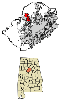
Location of Graysville in Jefferson County, Alabama.
|
|
| Country | United States |
| State | Alabama |
| County | Jefferson |
| Area | |
| • Total | 16.07 sq mi (41.62 km2) |
| • Land | 16.05 sq mi (41.58 km2) |
| • Water | 0.01 sq mi (0.03 km2) |
| Elevation | 515 ft (157 m) |
| Population
(2020)
|
|
| • Total | 1,950 |
| • Density | 121.47/sq mi (46.90/km2) |
| Time zone | UTC-6 (Central (CST)) |
| • Summer (DST) | UTC-5 (CDT) |
| ZIP code |
35073
|
| Area code(s) | 205 & 659 |
| FIPS code | 01-31384 |
| GNIS feature ID | 2403734 |
Graysville is a city in Jefferson County, Alabama, in the United States. It is located north of Adamsville. In 2020, about 1,950 people lived there.
Contents
History of Graysville
Early Days: Gin Town
In the late 1800s and early 1900s, Graysville was known as Gin Town. This was because it had the only cotton gin for many miles. A cotton gin is a machine that quickly separates cotton fibers from their seeds. Because of this important machine, the community grew.
Becoming a City
Graysville first officially became a city in 1897. As more people moved in, there was a need for more businesses and places to worship. The Union Church was built in the early 1900s. People from all different religious groups met and worshipped there. It was the only church around for a long time.
However, in 1927, the city's official status was taken away. This happened because the city government was not very active.
Graysville Reborn
Graysville became a city again on November 17, 1945. The first meeting of the new city council happened on January 16, 1946. It took place at the old school house. Later that year, the city council started the Graysville Water Works system. This brought clean water to homes.
In 1949, they created the Graysville Gas Board. This board eventually became the Graysville Municipal Gas System, providing gas to the city.
Growth and Expansion
During the 1950s and 1960s, many families moved to Graysville. They came because of the local coal mines and steel mills, which offered jobs. This growth led to the building of the city's first housing developments. In the 1980s and 1990s, Graysville grew even more. It added many acres of land that were not part of any city before.
Weather Events
On January 23, 2012, an EF3 tornado caused damage in Graysville. An EF3 tornado is a strong type of tornado that can cause serious damage.
Geography of Graysville
Graysville is located at 33°37′37″N 86°57′44″W / 33.62694°N 86.96222°W. This helps pinpoint its exact spot on a map. The city covers a total area of about 6.3 square miles (16.3 square kilometers). All of this area is land.
People of Graysville
Population Changes Over Time
The number of people living in Graysville has changed over the years. You can see how the population has grown and shrunk in the table below.
| Historical population | |||
|---|---|---|---|
| Census | Pop. | %± | |
| 1900 | 319 | — | |
| 1910 | 428 | 34.2% | |
| 1930 | 244 | — | |
| 1950 | 879 | — | |
| 1960 | 2,870 | 226.5% | |
| 1970 | 3,182 | 10.9% | |
| 1980 | 2,642 | −17.0% | |
| 1990 | 2,241 | −15.2% | |
| 2000 | 2,344 | 4.6% | |
| 2010 | 2,165 | −7.6% | |
| 2020 | 1,950 | −9.9% | |
| U.S. Decennial Census 2013 Estimate |
|||
Who Lives in Graysville?
According to the 2020 United States census, there were 1,950 people living in Graysville. These people lived in 765 households, which are like homes or families. About 542 of these were families.
The city is home to people from different backgrounds. Most residents are White, followed by Black or African American. There are also smaller numbers of Native American, Asian, and Pacific Islander residents. Some people identify with two or more races. A small percentage of the population is Hispanic or Latino.
| Race | Num. | Perc. |
|---|---|---|
| White (non-Hispanic) | 1,262 | 64.72% |
| Black or African American (non-Hispanic) | 536 | 27.49% |
| Native American | 6 | 0.31% |
| Asian | 7 | 0.36% |
| Pacific Islander | 2 | 0.1% |
| Other/Mixed | 73 | 3.74% |
| Hispanic or Latino | 64 | 3.28% |
See also
 In Spanish: Graysville (Alabama) para niños
 | Jessica Watkins |
 | Robert Henry Lawrence Jr. |
 | Mae Jemison |
 | Sian Proctor |
 | Guion Bluford |

