
Great and Little Kimble cum Marsh facts for kids
Quick facts for kids Great and Little Kimble cum Marsh |
|
|---|---|
 Great Kimble Church |
|

Great and Little Kimble cum Marsh
|
|
| Population | 1,026 (2011) |
| OS grid reference | SP824065 |
| Civil parish |
|
| Unitary authority |
|
| Ceremonial county | |
| Region | |
| Country | England |
| Sovereign state | United Kingdom |
| Post town | AYLESBURY |
| Postcode district | HP17 |
| Dialling code | 01296 |
| Police | Thames Valley |
| Fire | Buckinghamshire |
| Ambulance | South Central |
| EU Parliament | South East England |
| UK Parliament |
|
Great and Little Kimble cum Marsh is a group of villages and hamlets in central Buckinghamshire, England. It's about 5 miles (8 km) south of Aylesbury. This area includes the old villages of Great Kimble, Little Kimble, Kimblewick, and Marsh, plus a small part of Great Kimble called Smokey Row.
The two main villages, Great Kimble and Little Kimble, joined together in 1885. However, they still have their own churches: St Nicholas for Great Kimble and All Saints for Little Kimble. The area is known for its long history, dating back to the time of the Celts and Romans. It has always been a farming community.
Contents
What's in a Name? The Origin of Kimble
The name 'Kimble' has a mysterious past, but many people think it comes from Anglo-Saxon times. It might have been called 'Cyne Belle', which means 'royal bell'.
- Royal Hill? Some believe 'belle' meant 'hill'. So, 'Cyne Belle' could mean 'royal hill', referring to Pulpit Hill. This hill is very noticeable and has an ancient fort on top. Maybe it was called 'royal' because it was the biggest hill around, or because a king was buried there.
- King Cunobeline? Another idea connects the name to an ancient Celtic king named Cunobeline. He lived around 4 BC to 41 AD and might have used the hillfort on Pulpit Hill. However, the name 'Cyne Belle' appeared much later, so this link is not certain.
Even today, the exact meaning of 'Royal Bell' for the people who lived here long ago is a bit of a puzzle!
Ancient Hillfort on Pulpit Hill
On top of Pulpit Hill in Great Kimble, there's an ancient hillfort. It's about 813 feet (248 m) above sea level. We don't know its exact age, but it was likely built over 2,500 years ago during the Iron Age.
- What is a Hillfort? Hillforts are usually large, circular forts built on hills. They were often used for protection.
- Shape and Size: The Pulpit Hill fort is roughly D-shaped and covers about 0.9 hectares (2.2 acres). It still has double walls and ditches on some sides. On other sides, the builders used the very steep natural slopes for defense.
- Purpose: This fort was probably not just for fighting. Because it's hidden deep in Pulpit Wood, it might have been a place to store farm goods, keep animals safe from raids, or even for special religious ceremonies.
Roman Life and Burial Mounds
Great and Little Kimble also have links to the Roman Empire.
- Roman Villa: In Little Kimble, near the church, there are signs of a Roman villa. Over the last 200 years, people have found old foundations, wall plaster, fancy floor tiles, coins, and pottery. This villa would have been the home of a wealthy landowner who farmed a large estate.
- Dial Hill: Near St Nicholas's church in Great Kimble, there's a burial mound called Dial Hill. It's thought to be from the Roman period. Some believe it might hold the body of the person who lived in the Roman villa.
Medieval Times and Beyond
Norman Conquest and Domesday Book
Before the Norman conquest of England in 1066, both Great and Little Kimble were owned by important Anglo-Saxon lords. After the Normans took over, the new king, William the Conqueror, gave these lands to his own followers.
- Great Kimble: Was given to Walter Giffard, a powerful Norman lord.
- Little Kimble: Went to Thurston son of Rolf.
The Domesday Book, a famous survey from 1087, recorded details about these villages. It showed how much land they had, how many people lived there, and what their value was.
Motte and Bailey Castle
Behind the church in Little Kimble, you can still see mounds and banks in the grass. These are the remains of a motte and bailey castle.
- What is it? These were early Norman castles made of wood. They had a tall mound (the 'motte') with a wooden tower on top, and a fenced area (the 'bailey') with other buildings.
- Purpose: Unlike the big stone castles built later, these wooden forts were mainly for the local Norman lord to live safely among the English people he now ruled.
John Hampden and Ship-Money

Great Kimble is famous because of an important event that led to the English Civil War. In 1635, John Hampden, a local landowner, refused to pay a tax called 'ship-money' here.
- What was Ship-Money? King Charles I wanted to raise money for his navy without asking Parliament. So, he made all counties pay 'ship-money'. Even though it was meant to provide ships, people saw it as a new tax.
- Why did Hampden refuse? It was a long-standing rule that the king couldn't raise taxes without Parliament's agreement. John Hampden paid other taxes, but he refused to pay ship-money in Great Kimble (and another village) because he believed it was against the law.
- The Impact: Many others followed his example. The king sued Hampden in a famous court case. Even though the judges sided with the king, it was a close decision. This made many more people refuse to pay, showing that the king's power was being challenged. This event was a big step towards the English Civil War.
Churches of Kimble


_from_west.jpg)
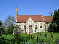
St Nicholas Church, Great Kimble
This church has been around since the 12th century. Over time, it was made bigger.
- Building History: In the 13th century, side sections (aisles) were added. The tower and upper windows were built later in the 14th century.
- Special Features: The church has a beautiful old font from the late 12th century. It's a great example of the local "Aylesbury" style.
- Restoration: The church was fully repaired and restored in the late 1800s, giving it the look it has today.
All Saints Church, Little Kimble
All Saints Church also dates back to before the mid-13th century.
- Building History: The church was expanded in the 13th century. Many of its doors and windows were added in the early to mid-14th century.
- Inside the Church: You can see medieval tiles from the 13th century. The walls are decorated with old paintings from the early 14th century. These paintings show saints, including St Francis talking to birds and a large picture of St George. There's also a painting on the west wall that seems to show a 'doom' scene, where a devil pushes people into what looks like the mouth of Hell.
- All Saints Church, Little Kimble
-
All Saints Church from the south
-
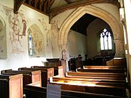
Inside the church, showing the nave and chancel
-
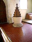
The Font (around 1200)
-
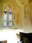
A wall painting of St Francis preaching to the birds
-
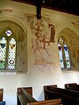
A wall painting of St George


Other Churches
- Free Church: There's a small chapel built in 1922 in Little Kimble.
- St Faiths: In Marsh, St Faiths was once a small chapel but is now a private house.
Local Life and Transport
Public Houses
The Swan in Great Kimble is the only pub still open in the area. Other pubs, like The Prince of Wales in Marsh, are now closed. Great Kimble also used to have the Bernard Arms, which was famous for its links to Chequers, the Prime Minister's country house nearby. Important visitors like Harold Wilson and Boris Yeltsin stayed there.
Education
Griffin House School, previously called Ladymede School, is a private school in Little Kimble. It teaches over 100 students aged 3 to 11.
- Famous Former Students:
* Arabella Churchill * India Hicks * Kelly LeBrock
Notable People
- Jerome Horsey: A famous traveler and diplomat.
- John Hampden: The landowner who famously refused to pay ship-money.
Transport Links
The main A4010 road runs through Great and Little Kimble cum Marsh. The Chiltern railway line also passes through, connecting Aylesbury and Princes Risborough. Little Kimble railway station has been open since 1872, though the station buildings are now a private home.
